
Cheddar is a large village and civil parish in the Sedgemoor district of the English county of Somerset. It is situated on the southern edge of the Mendip Hills, 9 miles (14 km) north-west of Wells, 11 miles (18 km) south-east of Weston-super-Mare and 18 miles (29 km) south-west of Bristol. The civil parish includes the hamlets of Nyland and Bradley Cross. The parish had a population of 5,755 in 2011 and an acreage of 8,592 acres (3,477 ha) as of 1961.

Bath and North East Somerset (B&NES) is a unitary authority district in England. Bath and North East Somerset Council was created on 1 April 1996 following the abolition of the county of Avon. It is part of the ceremonial county of Somerset.

The Mendip Hills is a range of limestone hills to the south of Bristol and Bath in Somerset, England. Running from Weston-super-Mare and the Bristol Channel in the west to the Frome valley in the east, the hills overlook the Somerset Levels to the south and the Chew Valley and other tributaries of the Avon to the north. The hills give their name to the local government district of Mendip, which administers most of the area. The higher, western part of the hills, covering 198 km2 (76 sq mi) has been designated an Area of Outstanding Natural Beauty (AONB), which gives it a level of protection comparable to a national park.
The River Chew is a small river in England that flows for some 17 miles (27 km) through the North Somerset countryside to form the Chew Valley before merging with the River Avon.

Chew Valley Lake is a reservoir in Chew Stoke, Chew Valley, Somerset, England. It is the fifth-largest artificial lake in the United Kingdom, with an area of 1,200 acres (4.9 km2). The lake, created in the early 1950s, was opened by Queen Elizabeth II in 1956. It provides much of the drinking water for the city of Bristol and surrounding area, taking its supply from the Mendip Hills. Some of the lake water is used to maintain the flow in the River Chew.

Shipham is a village and civil parish in Somerset, England. It is on the western edge of the Mendip Hills near the A38, approximately 15 miles (24 km) south of Bristol. It is in the local government district of Sedgemoor. The parish includes the village of Rowberrow and the hamlet of Star. The parish population, according to the 2011 census, is 1,087.

Blagdon Lake lies in a valley at the northern edge of the Mendip Hills, close to the village of Blagdon and approximately 10 miles (16 km) south of Bristol, England. The lake was created by Bristol Water, when it dammed the River Yeo, starting construction in 1898, to designs by Charles Hawksley, and completing this in 1905. The Wrington Vale Light Railway was constructed primarily to bring building materials for the lake.
The Chew Valley is an affluent area in North Somerset, England, named after the River Chew, which rises at Chewton Mendip, and joins the River Avon at Keynsham. Technically, the area of the valley is bounded by the water catchment area of the Chew and its tributaries; however, the name Chew Valley is often used less formally to cover other nearby areas, for example, Blagdon Lake and its environs, which by a stricter definition are part of the Yeo Valley. The valley is an area of rich arable and dairy farmland, interspersed with a number of villages.

Bristol Water is a British water company which supplies 266 million litres of drinking water daily to over 1.2 million customers in a 2,600 km2 (1,000 sq mi) area centred on Bristol, England. It is regulated under the Water Industry Act 1991. Sewerage services in the Bristol area are provided by Wessex Water.

Litton Reservoirs are two reservoirs near the village of Litton, Somerset, England. They are operated by Bristol Water.

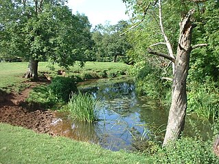
Chew Magna Reservoir is a 5-acre (2 ha) reservoir on the western outskirts of the village of Chew Magna, Somerset, England. It lies just north of the B3130 Winford Road.
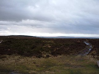
Black Down is the highest hill in the Mendip Hills, Somerset, in south-western England. Black Down lies just a few miles eastward of the Bristol Channel at Weston-super-Mare, and provides a view over the Chew Valley. The summit is marked with an Ordnance Survey trig point, the base of which has been rebuilt by the Mendip Hills AONB authority.
The Mendip Way is an 80-kilometre (50 mi) long-distance footpath across the Mendip Hills from Weston-super-Mare to Frome. It is divided into two sections.
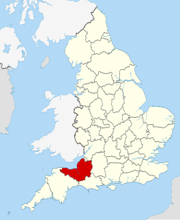
The county of Somerset is in South West England, bordered by the Bristol Channel and the counties of Bristol and Gloucestershire to the north, and Wiltshire to the east, Dorset to the south, and Devon to the west. The climate, influenced by its proximity to the Atlantic Ocean and the prevailing westerly winds, tends to be mild, damp and windy.

The Cheddar Yeo is a small river in Somerset, England. Beneath the limestone of the Mendip Hills it forms the largest underground river system in Britain. After emerging into Cheddar Gorge it flows through the village of Cheddar, where it has been used in the past to power mills. From the Middle Ages until the 19th century the river had ports for seagoing vessels but is no longer navigable. Some of the water, which is of good quality, is diverted into Cheddar Reservoir to provide drinking water for Bristol.

The Land Yeo is a small river which flows through North Somerset, England.

Reservoir Hole is a cave in Cheddar Gorge in Somerset, southwest England. It contains what is believed to be the largest chamber yet found under the Mendip Hills.

Samaritans Way South West is a 103 miles (166 km) Long-distance footpath in South West England. It was officially opened on 21 April 2004 by the Ramblers Vice Chairman, the Samaritans (charity) Chief Executive and a farmer from Gloucestershire who headed the Farmers Helpline. In the same year it appeared on the Ordnance Survey maps supported and encouraged by Local Authorities, National Parks and Area of Outstanding Natural Beauty by giving their consent; however Somerset County Council later asked the Ordnance Survey to remove the route from their maps.

Chew Stoke Flood was a heavy rain event and severe flash flood which occurred on 10 July 1968, affecting Somerset and Southwest England in particular the Chew Valley and some areas of Bristol, notably Bedminster. The River Chew suffered a major flood in 1968 with serious damage to towns and villages along its route, including sweeping away the bridge at Pensford.
