History
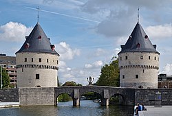
Although they look identical, the towers were not built at the same time. The Southern tower, also known as the Speyetoren, was built in 1385 to control the traffic on the river Lys. This tower was part of the fortified fence of the first medieval castle of the Counts of Flanders. The Speyentoren was also part of the 12th century rampart, destroyed by Louis XIV in the 17th century.
The Northern tower, known as the Ingelborchtoren was built in 1415 and was used as an armory.
Nowadays, the towers are, together with the Artillerytower (in Dutch: Artillerietoren), the last remaining parts of the medieval city wall around the city. Most of the fortifications in Kortrijk were ordered to be destroyed by Vauban in 1683, a period in which the French and the Spanish armies repeatedly fought over control of the region. The remaining parts were destroyed in the 18th century and during the world wars.
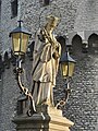
A statue of John of Nepomuk can be found in the middle of the bridge spanning between the two towers. This statue of the patron saint of the drowned has, ironically, fallen into the river Lys on several occasions due to warfare in the city. The bridge between the two towers was destroyed in both world wars.
Arnhem is a city and municipality situated in the eastern part of the Netherlands. It is the capital of the province of Gelderland, located on both banks of the rivers Nederrijn and Sint-Jansbeek, which was the source of the city's development. Arnhem had a population of 159,265 in 2019, which made it one of the larger cities of the Netherlands. The municipality is part of the Arnhem–Nijmegen metropolitan area which has a combined 736,500 inhabitants.

Zutphen is a city and municipality located in the province of Gelderland, Netherlands. It lies some 30 km northeast of Arnhem, on the eastern bank of the river IJssel at the point where it is joined by the Berkel. First mentioned in the 11th century, the place-name appears to mean "south fen". In 2005, the municipality of Zutphen was merged with the municipality of Warnsveld, retaining its name. In 2019, the municipality had a population of 47,609.

Orléans is a city in north-central France, about 120 kilometres southwest of Paris. It is the prefecture of the Loiret department and of the Centre-Val de Loire region, and is located in the Orléanais province.

Komárno is a town in Slovakia at the confluence of the Danube and the Váh rivers. Historically it was formed by the "old town" on the left bank of Danube, present day Komárno in Slovakia, and by a "new town" on the right bank, present day Komárom in Hungary, which were historically one administrative unit. Following World War I and the Treaty of Trianon, the border of the newly created Czechoslovakia cut the historical, unified town in half, creating two new independent towns in two countries. Komárno and Komárom are connected by the Elisabeth Bridge, which used to be an official border crossing between Slovakia and Hungary until border checks were lifted due to the Schengen Area rules. In 2020, a new road bridge was opened.

The London Wall was a defensive wall first built by the Romans around the strategically important port town of Londinium in c. AD 200. It has origins as an initial mound wall and ditch from c. AD 100 and an initial fort, now called Cripplegate fort after the city gate that was positioned within its northern wall later on, built in 120-150 where it was then expanded upon by Roman builders into a city-wide defence. Over time, as Roman influence waned through the departure of the Roman army in c. 410, their withdrawal led to its disrepair, as political power on the island dispersed through the Heptarchy period of Anglo-Saxon England. From the conquest of William the Conqueror, successive medieval restorations and repairs to its use have been undertaken. This wall largely defined the boundaries of the City of London until the later Middle Ages, when population rises and the development of towns around the city blurred the perimeter.

Bruck an der Leitha is a city in Lower Austria, Austria at the border to the Burgenland, which is marked by the Leitha river.

As with other cities in Ireland, Limerick has a history of great architecture. A 1574 document prepared for the Spanish ambassador attests to its wealth and fine architecture:

Nymburk is a town in the Central Bohemian Region of the Czech Republic. It has about 15,000 inhabitants. It is located 45 km (28 mi) east of Prague on the Elbe River. The town centre is well preserved and is protected by law as an urban monument zone.

Marienberg Fortress is a prominent landmark on the left bank of the Main river in Würzburg, in the Franconia region of Bavaria, Germany. The mighty Fortress Marienberg is a symbol of Würzburg and served as a home of the local prince-bishops for nearly five centuries. It has been a fort since ancient times. Most of the current structures originally were built in Renaissance and Baroque styles between the 16th and 18th centuries. After Gustavus Adolphus of Sweden conquered the area in 1631 during the Thirty Years' War, the castle was reconstructed as a Baroque residence. After it ceased to serve as residence of the Bishops of Würzburg, the fortress saw repeated action in the wars of the late 18th and 19th centuries. Festung Marienberg was severely damaged by British bombs in March 1945 and only fully rebuilt in 1990. Today, it houses two museums.

The fortifications of London are extensive and mostly well maintained, though many of the City of London's fortifications and defences were dismantled in the 17th and 18th century. Many of those that remain are tourist attractions, most notably the Tower of London.

Bratislava fortifications usually refers to the medieval city fortifications of Bratislava, the capital of Slovakia, of which one gate and two sections of walls remain today. The Bratislava Castle was also heavily fortified. Other fortification systems were built in the following centuries, including a World War I artillery fortification system and World War I shelters, system of bunkers and fortifications built by the First Czechoslovak Republic between the World Wars, World War II aircraft raid shelters, fortifications built by the Nazi Germany in the city during World War II and finally Cold War-era city defenses including a system of 8,602 air raid and nuclear shelters capable of holding over 760,000 citizens, far more than the number of inhabitants. The pinnacle of the communist era city defense was a military rocket base located on the Devínska Kobyla hill, the highest point in the city.
The Fortifications of Brussels refers to the medieval city walls that surrounded Brussels, Belgium, built primarily to defend the city but also for administrative reasons. There were two stages of fortifications of Brussels; the first walls, built in the early 13th century, and the second walls, built in the late 14th century and later upgraded. Today, only a few sections of either remain.

Kortrijk, known in English as Courtrai or Courtray, is a Belgian city and municipality in the Flemish province of West Flanders.
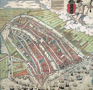
The walls of Amsterdam were built in the Middle Ages to protect the city against attack. The Medieval walls were replaced with a series of bastions in the 17th century. In the 19th century, the walls were torn down and replaced with the Defence Line of Amsterdam, a fortification line which encircled Amsterdam at a distance from the city.

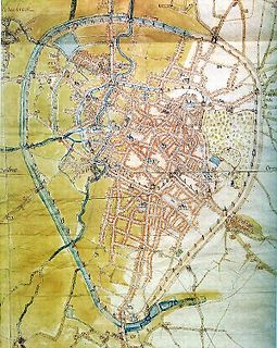
Buda is a historical neighbourhood in the Belgian city of Kortrijk. The neighbourhood is part of the historical old town. Since it lies between two branches of the River Leie, it is an island and is also called the 'Buda-island'.

The fortifications of Malta consist of a number of walled cities, citadels, forts, towers, batteries, redoubts, entrenchments and pillboxes. The fortifications were built over thousands of years, from around 1450 BC to the mid-20th century, and they are a result of the Maltese islands' strategic position and natural harbours, which have made them very desirable for various powers.

The Karl Theodor Bridge, commonly known as the Old Bridge, is an arch bridge in Heidelberg that crosses the Neckar river. It connects the Old City with the eastern part of the Neuenheim district of the city on the opposite bank. The current bridge, made of Neckar sandstone and the ninth built on the site, was constructed in 1788 by Elector Charles Theodore, and is one of the best-known landmarks and tourist destinations in Heidelberg.

Melite or Melita was an ancient city located on the site of present-day Mdina and Rabat, Malta. It started out as a Bronze Age settlement, which developed into a city called Maleth under the Phoenicians, and became the administrative centre of the island. The city fell to the Roman Republic in 218 BC, and it remained part of the Roman and later the Byzantine Empire until 870 AD, when it was captured and destroyed by the Aghlabids. The city was then rebuilt and renamed Medina, giving rise to the present name Mdina. It remained Malta's capital city until 1530.

The Alte Nahebrücke is a medieval stone arch bridge in Bad Kreuznach, in western Germany, dating from around 1300, that originally spanned the Nahe river and a neighbouring canal called the Mühlenteich. Only the section spanning the canal remains intact. With four houses on its piers, it is one of the few remaining bridges in the world that has buildings on it.

The fortifications of Frankfurt were a system of military defences of the German city of Frankfurt am Main which existed from the Middle Ages into the 19th century. Around 1000 the first city wall was built. It enclosed the area of what is now the Königspfalz in modern Frankfurt. In the twelfth century the settlement expanded into what is now Altstadt. For its protection an additional wall, the Staufenmauer, was erected. Starting in 1333, the Neustadt suburb developed north of the Altstadt and was encompassed by an additional wall with five gates. In the fifteenth century, a "landwehr border" was created around the entire territory of the Free City of Frankfurt. Beginning in 1628, the medieval city wall was developed to form a bastion fortress under the municipal architect Johann Dilich.