
Bavaria, officially the Free State of Bavaria, is a landlocked state of Germany, occupying its southeastern corner. With an area of 70,550.19 square kilometres (27,239.58 sq mi) Bavaria is the largest German state by land area comprising roughly a fifth of the total land area of Germany. With 13 million inhabitants, it is Germany's second-most-populous state after North Rhine-Westphalia. Bavaria's main cities are Munich, Nuremberg, and Augsburg.
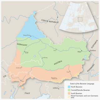
Austro-Bavarian is a major group of Upper German varieties spoken in the southeast of the German language area, much of Bavaria, most of Austria and South Tyrol in Italy, as well as Samnaun in Switzerland. Before 1945, Austro-Bavarian was also prevalent in parts of the southern Czech Republic and western Hungary. Bavarian forms a continuum of more or less mutually intelligible local and regional variants.

The Iller (help·info) is a river of Bavaria and Baden-Württemberg in Germany. It is a right tributary of the Danube, 146 kilometres (91 mi) long.
The Regen is a river in Bavaria, Germany, and a left tributary of the Danube, at Regensburg, Germany. The source of its main headstream, the Great Regen, is in the Bohemian Forest on the territory of the Czech Republic, near Železná Ruda. The river crosses the border after a few kilometres, at Bayerisch Eisenstein. The name in German evolved from the name in Latin, but its meaning is unknown. The Romans called the river variously Regana, Reganus (masculine), and Reganum (neuter).

The Ilz is a river running through the Bavarian Forest, Germany. It is a left tributary of the Danube and 40 km (25 mi) in length, during which it travels down a height difference of ~140m.

Bavarians are an ethnographic group of Germans of the Bavaria region, a state within Germany. The group's dialect or speech is known as the Bavarian language, native to Altbayern, roughly the territory of the Electorate of Bavaria in the 17th century.

Central Bavarian, also known as Central Austro-Bavarian, form a subgroup of Bavarian dialects in large parts of Austria and the German state of Bavaria along the Danube river, on the northern side of the Eastern Alps. They are spoken in the 'Old Bavarian' regions of Upper Bavaria, Lower Bavaria and in the adjacent parts of the Upper Palatinate region around Regensburg, in Upper and Lower Austria, in Vienna, in the state of Salzburg, as well as in the northern and eastern parts of Styria and Burgenland.

The Duchy of Bavaria was a frontier region in the southeastern part of the Merovingian kingdom from the sixth through the eighth century. It was settled by Bavarian tribes and ruled by dukes (duces) under Frankish overlordship. A new duchy was created from this area during the decline of the Carolingian Empire in the late ninth century. It became one of the stem duchies of the East Frankish realm which evolved as the Kingdom of Germany and the Holy Roman Empire.

The Tauber (help·info) is a river in Franconia, Germany. It is a left tributary of the Main and is 132 km (82 mi) in length. The name derives from the Celtic word for water.
The Naab is a river in Bavaria, Germany, and is a left tributary of the Danube. Including its main source river Waldnaab, it is 196.6 km (122 mi) long.
The Kingdom of Bavaria was a German state that succeeded the former Electorate of Bavaria in 1805 and continued to exist until 1918. The Bavarian Elector Maximilian IV Joseph of the House of Wittelsbach became the first King of Bavaria in 1805 as Maximilian I Joseph. The crown would go on being held by the Wittelsbachs until the kingdom came to an end in 1918. Most of Bavaria's present-day borders were established after 1814 with the Treaty of Paris, in which Bavaria ceded Tyrol and Vorarlberg to the Austrian Empire while receiving Aschaffenburg and Würzburg. With the unification of Germany into the German Empire in 1871, the kingdom became a federated state of the new empire and was second in size, power, and wealth only to the leading state, the Kingdom of Prussia. In 1918, Bavaria became a republic, and the kingdom was thus succeeded by the current Free State of Bavaria.

The Würm is a river in Bavaria, Germany, right tributary of the Amper. The length of the river is 39.8 kilometres (24.7 mi), or 76.3 kilometres (47.4 mi) including the Steinbach, the main feed of Lake Starnberg. It drains the overflow from Lake Starnberg and flows swiftly through the villages of Gauting, Krailling, Planegg, Gräfelfing and Lochham as well as part of Munich before joining, near Dachau, the Amper, which soon afterwards flows into the Isar and eventually flowing into the Danube. Although the Würm is not a very large river, it is well known as it gave its name to the Würm glaciation.
Southern Germany as a region has no exact boundary but is generally taken to include the areas in which Upper German dialects are spoken. That corresponds roughly to the historical stem duchies of Bavaria and Swabia or, in a modern context, to Bavaria and Baden-Württemberg within the Federal Republic of Germany, to the exclusion of the areas of the modern states of Austria and Switzerland. The Saarland and the southern parts of Hesse and Rhineland-Palatinate are sometimes included as well and correspond to the historical Franconia.

The Rott is a 111 km (69 mi) long river in Bavaria, Germany, left tributary of the Inn. Its source is in the municipality Wurmsham in Lower Bavaria, between Landshut and Waldkraiburg. It flows east through a rural area with small towns, including Neumarkt-Sankt Veit, Eggenfelden, Pfarrkirchen and Pocking. It flows into the Inn near Neuhaus am Inn, opposite of Schärding, on the border with Austria.

The Bavarian State Police is the state police force of the German state of Bavaria. It has approximately 33,500 armed officers and roughly 8,500 other civilian employees.

The Wörnitz is a river in Bavaria, Germany, a left tributary of the Danube. Its source is near Schillingsfürst, in the Middle Franconia region of Bavaria. It flows south, through the Nördlinger Ries, and flows into the Danube in Donauwörth. Towns along the Wörnitz include Wörnitz, Dinkelsbühl, Wassertrüdingen, Oettingen, Harburg and Donauwörth.

The Günz is a river in Bavaria, Germany.
The Vils is a river in Bavaria, Germany.

The Itz is a river of Thuringia and Bavaria, Germany.

Wiesent is a river located in Bavaria, Germany. It is a right tributary of the river Regnitz. It is the main river of the Franconian Switzerland region, rising near the village Steinfeld. It flows through the towns Hollfeld, Muggendorf and Ebermannstadt, and joins the Regnitz in Forchheim.