Related Research Articles

Kansas City, abbreviated as "KCK", is the third-largest city in the U.S. state of Kansas, the county seat of Wyandotte County, and the third-largest city of the Kansas City metropolitan area. As of the 2020 census, the population of the city was 156,607. The city formed as a streetcar suburb of Kansas City, Missouri, after which it is named. It is situated at Kaw Point, the junction of the Missouri and Kansas rivers. It is part of a consolidated city-county government known as the "Unified Government". Wyandotte County also includes the independent cities of Bonner Springs, Edwardsville, a portion of Lake Quivira, and the unincorporated area known as Loring.

The Kansas City metropolitan area is a bi-state metropolitan area anchored by Kansas City, Missouri. Its 14 counties straddle the border between the U.S. states of Missouri and Kansas. With 8,472 square miles (21,940 km2) and a population of more than 2.2 million people, it is the second-largest metropolitan area centered in Missouri and is the largest metropolitan area in Kansas, though Wichita is the largest metropolitan area centered in Kansas. Alongside Kansas City, Missouri, these are the suburbs with populations above 100,000: Overland Park, Kansas; Kansas City, Kansas; Olathe, Kansas; Independence, Missouri; and Lee's Summit, Missouri.
Waldo is a neighborhood located in south Kansas City, Missouri, that has continued to maintain its own unique character, even though it was annexed by Kansas City in 1909. Waldo's boundaries are Gregory Boulevard on the north to 85th Street on the south, and Holmes Street on the east to Ward Parkway on the west.

The Crossroads is a neighborhood within Greater Downtown with a population of 7,491. It is centered at approximately 19th Street and Baltimore Avenue, directly south of the Downtown Loop and north of Crown Center. It is the city's main art gallery district and center for the visual arts. Dozens of galleries are located in its renovated warehouses and industrial buildings. It is also home to numerous restaurants, housewares shops, architects, designers, an advertising agency, and other visual artists. The district also has several live music venues.

Quality Hill is a historic neighborhood near downtown Kansas City, Missouri, USA, on a 200-foot-high bluff which overlooks the confluence of the Kansas and Missouri rivers in the West Bottoms below.
Brookside may refer to:
The list of neighborhoods of Kansas City, Missouri has nearly 240 neighborhoods. The list includes only Kansas City, Missouri and not the entire Kansas City metropolitan area, such as Kansas City, Kansas.

Ward Parkway is a boulevard in Kansas City, Missouri, United States, near the Kansas-Missouri state line. Ward Parkway begins at Brookside Boulevard on the eastern edge of the Country Club Plaza and continues westward along Brush Creek as U.S. Route 56 until it turns southward across the creek just before the Kansas-Missouri state line. It then continues south for four miles, terminating at Wornall Road near West 95th Street.
The Country Club District is the name of a group of neighborhoods comprising a historic upscale residential district in Kansas City, developed by noted real estate developer J.C. Nichols. The district was developed in stages between 1906 and 1950, and today is home to approximately 60,000 and includes such well-known Kansas City neighborhoods as Sunset Hill and Brookside in Missouri, Mission Hills, Fairway, and the oldest parts of Prairie Village in Kansas, making it the largest planned community built by a single developer in the United States. Ward Parkway, a wide, manicured boulevard, traverses the district running south from the Country Club Plaza, the first suburban shopping district in the United States.

The Library District is an officially designated neighborhood in Downtown Kansas City, Missouri, United States, roughly bounded by 9th and 11th Streets on the north and south and Main Street and Broadway on the east and west. The District contains a sub-district named the West Ninth Street/Baltimore Avenue Historic District listed on the National Register and which includes several buildings individually listed on the National Register of Historic Places. It also contains other notable structures not listed on the National Register.

The Uptown Theater is a historic theater located in Kansas City, Missouri. The building was listed on the National Register of Historic Places in 1979 as the Uptown Building and Theatre.
Southwest Early College Campus, often shortened to Southwest, was a university preparatory middle school and high school campus located at 6512 Wornall Road in Kansas City, Missouri, 64113, United States. It was part of the Kansas City, Missouri School District. The school closed on May 17, 2016.

The Mack B. Nelson house is a historic residence located at 5500 Ward Parkway in the Sunset Hill neighborhood of the Country Club District in Kansas City, Missouri.

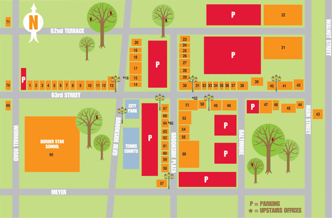
The Brookside Shopping District is located in the Brookside neighborhood of Kansas City, Missouri at 63rd Street & Brookside Boulevard. This district was founded in 1920 as Kansas City's first suburban shopping center.

Armour Hills is a neighborhood located in Kansas City, Missouri. It is bounded on the west by Brookside Road, on the north by 65th Street, on the east by Oak Street and the south by Gregory Boulevard. The name of this area derives from the fact that the land was owned by members of the Armour family of the Armour and Company.
West Plaza is a neighborhood in Kansas City, Missouri located just west of the Country Club Plaza district. It is an eclectic urban neighborhood of single-family housing, small apartment buildings, and storefront businesses.

The Kansas City Club Building is a 15-story building in downtown Kansas City, Missouri, built in 1920. It has been listed on the National Register of Historic Places since 2002.
Wornall Road is a major north–south road in Kansas City, Missouri. It is named for John Bristow Wornall, an early settler of Kansas City, whose estate still stands today as a museum.

The Raphael Hotel is a historic nine-story hotel located at 325 Ward Parkway in the Country Club Plaza district in Kansas City, Missouri. It is a locally significant landmark that originally opened in 1928 as Villa Serena Apartments, a block of luxury apartments. Its Italian Renaissance Revival style architecture was designed to complement the Spanish style of the nascent Country Club Plaza developed in the early 1920s. The nine-story building was purchased by the J.C. Nichols Company in 1974, remodeled and re-opened as The Raphael in 1975. The 126-room hotel is patterned after small European hotels. The property is a member of the Historic Hotels of America since 2001 and was listed in the National Register of Historic Places in 2009. Raphael Hotel is affiliated with the Marriott Autograph Collection. As of 2017, Raphael hotel had a restaurant named Chaz.
References
- ↑ "National Register of Historic Places Inventory-Nomination Form" (PDF). National Register of Historic Places : National Archive. 1975-01-20. Retrieved 2019-07-24.