Related Research Articles
Harrison is a census-designated place (CDP) in Hamilton County, Tennessee, United States. The population was 7,902 at the 2020 census. It is part of the Chattanooga metropolitan area. Harrison Bay State Park, the Hamilton County Landfill, Bear Trace Golf Course, a course designed by Jack Nicklaus, and Skull Island, a recreational area owned by TVA, are all located in Harrison.

New Hope is a town in Marion County, Tennessee, United States. The population is 987. It is part of the Chattanooga, TN–GA Metropolitan Statistical Area.
The First Battle of Chattanooga was a minor artillery battle in the American Civil War, fought on June 7–8, 1862.
Brown's Ferry may refer to:
The Second Battle of Chattanooga took place during the American Civil War, beginning on August 21, 1863, as the opening battle in the Chickamauga Campaign. The larger and more famous battles were the Battles for Chattanooga in November 1863.

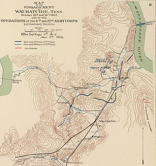
The Battle of Wauhatchie was fought October 28–29, 1863, in Hamilton and Marion counties, Tennessee, and Dade County, Georgia, in the American Civil War. A Union force had seized Brown's Ferry on the Tennessee River, opening a supply line to the Union army in Chattanooga. Confederate forces attempted to dislodge the Union force defending the ferry and again close this supply line but were defeated. Wauhatchie was one of the few night battles of the Civil War.

North and South Chickamauga Creek are short tributaries of the Tennessee River which join it near Chattanooga, Tennessee on the north and the south. West Chickamauga Creek is a much longer tributary of South Chickamauga Creek.

Missionary Ridge is a geographic feature in Chattanooga, Tennessee, site of the Battle of Missionary Ridge, a battle in the American Civil War, fought on November 25, 1863. Union forces under Maj. Gens. Ulysses S. Grant, William T. Sherman, and George H. Thomas routed Confederate forces under General Braxton Bragg and lifted the siege of the city.

Haletown is an unincorporated community in Marion County, Tennessee, United States. It is part of the Chattanooga, TN–GA Metropolitan Statistical Area. Haletown is probably best known as the former location of Hales Bar Dam, a major hydroelectric project completed in 1913 by the former Tennessee Electric Power Company (TEPCO) and as a prominent location along the Tennessee River at Nickajack Lake.

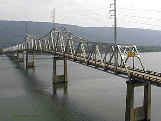
The B. B. Comer Bridge, was a two-lane, 2,143-foot (653 m) long, Warren truss bridge spanning the Tennessee River along Alabama State Route 35 in Scottsboro, Alabama. The bridge was named after Alabama governor Braxton Bragg Comer, who served from 1907 to 1911. Construction of the bridge was carried out by the Kansas City Bridge Company for the Alabama State Bridge Corporation. Its construction commenced in 1929 and was complete by 1931. As of 2013, this was the only remaining bridge of the 15 memorial toll bridges constructed by the Alabama State Bridge Corporation.

The Chattanooga campaign was a series of maneuvers and battles in October and November 1863, during the American Civil War. Following the defeat of Maj. Gen. William S. Rosecrans's Union Army of the Cumberland at the Battle of Chickamauga in September, the Confederate Army of Tennessee under Gen. Braxton Bragg besieged Rosecrans and his men by occupying key high terrain around Chattanooga, Tennessee. Maj. Gen. Ulysses S. Grant was given command of Union forces in the West, now consolidated under the Division of the Mississippi. Significant reinforcements also began to arrive with him in Chattanooga from Mississippi and the Eastern Theater. On October 18, Grant removed Rosecrans from command of the Army of the Cumberland and replaced him with Major General George Henry Thomas.
The Tennessee River Blueway is a 50-mile (80 km) section of the Tennessee River that flows between the Chickamauga Dam and the Nickajack Dam and through downtown Chattanooga, Tennessee and the Tennessee River Gorge. The City of Chattanooga, the Tennessee River Gorge Trust, and other agencies have designated the section of river as a blueway for canoe and kayak paddler. The Blueway has camping areas next to the river, as well as museums, restaurants, activities, entertainment, and natural attractions. From there, the Blueway meanders its way to quieter places like Williams Island State Archaeological Park. Williams Island divides the river channel with a 450-acre (1.8 km2) tract of land inhabited only by wildlife. From about 1000 to 1650, this area was home to several Native American tribes. It is now managed by the Tennessee River Gorge Trust. Then next of course is the 26-mile (42 km) stretch of the Tennessee River Gorge, a steep canyon formed by the Tennessee River. The land provides habitats for more than a thousand varieties of plants, ferns, trees, grasses and flowers as well as a wildlife population. Many of these are rare or endangered species such as the mountain skullcap. Dozens of archaeological sites bear evidence of man's presence in the Gorge for at least 10,000 years. There is a secluded spot where you can see Nickajack Cave from the water. Tennessee Valley Authority biologists monitor its bat population and encourage the public to "bat watch." There is no cave access, but canoeists and kayakers can observe the bats from the river.

The Battle of Brown's Ferry was an engagement of the American Civil War which took place on October 27, 1863 in Hamilton County, Tennessee. During the battle, two Union brigades drove Confederate sharpshooters from the Tennessee River, which allowed supplies to start arriving to the Union army at Chattanooga. Although a minor engagement, the battle proved to have significant results in paving the way for the Union victory at Chattanooga a month later.

Tenbridge is a vertical-lift railroad bridge over the Tennessee River in Chattanooga, Tennessee. It has a main span of 310 feet (94 m).

Ross's Landing in Chattanooga, Tennessee, is the last site of the Cherokee's 61-year occupation of Chattanooga and is considered to be the embarkation point of the Cherokee removal on the Trail of Tears. Ross's Landing Riverfront Park memorializes the location, which is listed on the National Register of Historic Places.
Chattanooga High School was founded in the fall of 1874 in Chattanooga, Hamilton County, Tennessee. The school, sometimes called City High School, has evolved into two high schools: the Chattanooga High School Center for Creative Arts and the Chattanooga School for the Arts & Sciences.
The following is a timeline of the history of the city of Chattanooga, Tennessee, United States.
Underground Chattanooga is a below-ground area of Chattanooga, Tennessee that resulted from citizen efforts to prevent floods in the aftermath of the flood of 1867. It was rediscovered by Jeff Brown in the 1970s.
Tiftonia is a neighborhood of Chattanooga, Tennessee and a former unincorporated community in Hamilton County, Tennessee. It is located in the western portion of the city along Interstate 24 and US Routes 11, 41, 64, and 72.

Cherokee Removal Memorial Park is a public park in Meigs County, Tennessee that is dedicated in memory of the Cherokee who were forced to emigrate from their ancestral lands during the Cherokee removal, in an event that came to be known as the Trail of Tears. It was established in 2005, and has since expanded.