
The Rio Grande, known in Mexico as the Río Bravo del Norte and as the Río Bravo, is one of the principal rivers in the southwestern United States and in northern Mexico. The length of the Rio Grande is 1,896 miles (3,051 km) and originates in south-central Colorado, in the United States, and flows to the Gulf of Mexico. The Rio Grande drainage basin (watershed) has an area of 182,200 square miles (472,000 km2); however, the endorheic basins that are adjacent to and within the greater drainage basin of the Rio Grande increase the total drainage-basin area to 336,000 square miles (870,000 km2).
Harlingen is a city in Cameron County in the central region of the Rio Grande Valley of the southern part of the U.S. state of Texas, about 30 miles (48 km) from the coast of the Gulf of Mexico. The city covers more than 40 square miles (104 km2) and is the second-largest city in Cameron County, as well as the fourth-largest in the Rio Grande Valley. As of the 2010 census, the city had a population of 74,924, for a growth rate of 12.5% since the 2000 census.

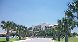
Brownsville is a city in Cameron County in the U.S. state of Texas. It is on the western Gulf Coast in South Texas, adjacent to the border with Matamoros, Mexico. The city covers 145.2 sq mi (376.066 km2), and has an estimated population of 182,781 as of 2019. It is the 131st-largest city in the United States and 18th-largest in Texas. It is part of the Matamoros–Brownsville metropolitan area. The city is known for its year-round subtropical climate, deep-water seaport, and Hispanic culture.
Los Indios is a U.S. bordertown in Cameron County, Texas. The population was 1,083 at the 2010 census. It is included as part of the Brownsville–Harlingen–Raymondville and the Matamoros–Brownsville metropolitan areas. The Free Trade International Bridge connects Los Indios with Matamoros, Tamaulipas.

Matamoros, officially known as Heroica Matamoros, is a city in the northeastern Mexican state of Tamaulipas, and the municipal seat of the homonymous municipality. It is on the southern bank of the Rio Grande, directly across the border from Brownsville, Texas, in the United States. Matamoros is the second largest city in the state of Tamaulipas. As of 2016, Matamoros had a population of 520,367. In addition, the Matamoros–Brownsville Metropolitan Area has a population of 1,387,985, making it the 4th largest metropolitan area on the Mexico–US border. Matamoros is the 39th largest city in Mexico and anchors the second largest metropolitan area in Tamaulipas.
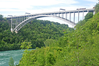
The Lewiston–Queenston Bridge, also known as the Queenston–Lewiston Bridge, is an arch bridge that crosses the Niagara River gorge just south of the Niagara Escarpment. The bridge was officially opened on November 1, 1962. It is an international bridge between the United States and Canada. It connects Interstate 190 in the town of Lewiston, New York to Highway 405 in the community of Queenston, Ontario. The Lewiston–Queenston Bridge is a twin of the Rainbow Bridge at Niagara Falls and designed by Richard Lee.

The Lower Rio Grande Valley, commonly known as the Rio Grande Valley or locally as The Valley, is a socio-cultural region spanning the border of Texas and Mexico located in a floodplain of the Rio Grande near its mouth. The region includes the southernmost tip of South Texas and a portion of northern Tamaulipas, Mexico. It consists of the Brownsville, Harlingen, Weslaco, Pharr, McAllen, Edinburg, Mission, San Juan, and Rio Grande City metropolitan areas in the United States and the Matamoros, Río Bravo, and Reynosa metropolitan areas in Mexico. These cities are surrounded by many small neighborhoods or colonias. The area is generally bilingual in English and Spanish, with a fair amount of Spanglish due to the diverse history of the region. A large seasonal influx occurs of "winter Texans" — Texans who come down from the north for the winter and then go back up north before summer arrives.

The Texas Mexican Railway was a railroad that operated as a subsidiary of the Kansas City Southern Railway in Texas. It is often referred to as the Tex-Mex, or TexMex Railway.
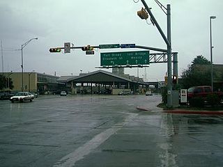
Gateway International Bridge is one of three international bridges that cross the U.S.-Mexico border between the cities of Brownsville, Texas, and Matamoros, Tamaulipas. It is owned and operated by Cameron County. Over the past century, it has developed the nickname of "The New Bridge" when the bridge was remodeled back in the 20th century. Despite the fact that the Veteran's International Bridge is newer than Gateway, it still retains its nickname.

The Brownsville & Matamoros International Bridge, also known as B&M International Bridge, Brownsville-Matamoros International Bridge and Express Bridge, is one of three international bridges that cross the U.S.-Mexico border between the cities of Brownsville, Texas, and Matamoros, Tamaulipas. This international bridge unites the Matamoros–Brownsville Metropolitan Area, which counts with a population of 1,136,995, making it the 4th largest metropolitan area in the Mexico-US border.
The Veterans International Bridge at Los Tomates is one of three international bridges that span the Mexico–United States border between the cities of Brownsville, Texas, and Matamoros, Tamaulipas. It is also known as simply as the Veterans Bridge, the Los Tomates Bridge, or on the Mexico side as the Puente Internacional Ignacio Zaragoza. The bridge is owned and operated by Cameron County.
Federal Highway 2 is a free part of the Mexican federal highway corridors that runs along the U.S. border. The highway is in two separate improved segments, starting in the west at Tijuana, Baja California, on the Pacific coast and ending in the east in Matamoros, Tamaulipas, on the Gulf of Mexico. Fed. 2 passes through the border states of Baja California, Sonora, Chihuahua, Coahuila, Nuevo Leon and Tamaulipas. It has a total length of 1,963 kilometres (1,220 mi); 1,319 kilometres (820 mi) in the west and 644 kilometres (400 mi) in the east.
Federal Highway 180 is a Mexican Federal Highway that follows Mexico's Gulf and Caribbean Coast from the Mexico-U.S. border at Brownsville, Texas, into Matamoros, Tamaulipas, to the resort city of Cancún, Quintana Roo, in the Yucatán Peninsula. Although the highway is numbered as a west-east route, it initially follows a north-south alignment through Tamaulipas and Veracruz.
Gilberto Hinojosa is an American politician. He is the chair of the Texas Democratic Party. Hinojosa was the county judge of Cameron County, Texas from 1995 to 2006.

The San Ysidro Port of Entry is the largest land border crossing between San Diego and Tijuana, and the fourth-busiest land border crossing in the world with 70,000 northbound vehicles and 20,000 northbound pedestrians crossing each day, in addition to southbound traffic. It connects Mexican Federal Highway 1 on the Mexican side with Interstate 5 on the American side. The San Ysidro Port of Entry is one of three ports of entry in the San Diego–Tijuana metropolitan region.

Matamoros–Brownsville, also known as Brownsville–Matamoros, or simply as the Borderplex, is one of the six transborder agglomerations along the Mexico–United States border. The city of Matamoros is situated in the Mexican state of Tamaulipas, on the south bank of the Rio Grande, while the city of Brownsville is located in the U.S. state of Texas, directly north across the bank of the Rio Grande. The Matamoros–Brownsville area is connected by four international bridges. In addition, this transnational conurbation area has a population of 1,136,995, making it the fourth-largest metropolitan area on the Mexico-U.S. border.

The Brownsville Gateway Port of Entry opened in 1926 with the completion of the Gateway International Bridge. The original bridge was a steel arch design, and arches, which have long been used to signify international gateways, were incorporated into the design of the Matamoros Gateway border station in the 1950s. Unfortunately, the steel arch bridge was not well maintained, and it was replaced with two flat deck spans in the late 1970s. All truck traffic has been prohibited since 1999.
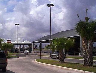
The Brownsville Veterans Port of Entry opened in 1999 with the completion of the Veterans International Bridge at Los Tomates. The bridge was built primarily to divert commercial freight traffic away from the busy downtown bridges, but about a third of the passenger vehicles also cross at this point. The Veterans Port of Entry is the easternmost US-Mexico border crossing, and is by far the newest of the three crossings between Brownsville and Matamoros.
The following is a timeline of the history of the city of Brownsville, Texas, USA.
