
Canada has a vast geography that occupies much of the continent of North America, sharing land borders with the contiguous United States to the south and the U.S. state of Alaska to the northwest. Canada stretches from the Atlantic Ocean in the east to the Pacific Ocean in the west; to the north lies the Arctic Ocean. Greenland is to the northeast and to the southeast Canada shares a maritime boundary with France's overseas collectivity of Saint Pierre and Miquelon, the last vestige of New France. By total area, Canada is the second-largest country in the world, after Russia. By land area alone, however, Canada ranks fourth, the difference being due to it having the world's largest proportion of fresh water lakes. Of Canada's thirteen provinces and territories, only two are landlocked while the other eleven all directly border one of three oceans.

Kootenay National Park is a national park of Canada located in southeastern British Columbia. The park consists of 1,406 km2 (543 sq mi) of the Canadian Rockies, including parts of the Kootenay and Park mountain ranges, the Kootenay River and the entirety of the Vermilion River. While the Vermilion River is completely contained within the park, the Kootenay River has its headwaters just outside the park boundary, flowing through the park into the Rocky Mountain Trench and eventually joining the Columbia River. The park ranges in elevation from 918 m (3,012 ft) at the southwestern park entrance to 3,424 m (11,234 ft) at Deltaform Mountain.
The Paria River is a tributary of the Colorado River, approximately 95 miles (153 km) long, in southern Utah and northern Arizona in the United States. It drains a rugged and arid region northwest of the Colorado, flowing through roadless slot canyons along part of its course.
The Glacial till plains are a till plain landform in Northern Ohio, located near the shore of Lake Erie and created by the retreat of the Wisconsin glaciation. Since glacial till is highly fertile soil, agriculture on the glacial till plains is very productive.
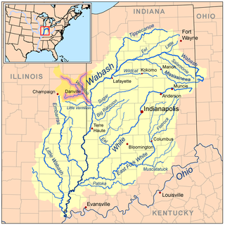
The Vermilion River is a tributary of the Wabash River in the states of Illinois and Indiana, United States.

Papakating Creek is a 20.1-mile-long (32.3 km) tributary of the Wallkill River located in Frankford and Wantage townships in Sussex County, New Jersey in the United States. The creek rises in a small swamp located beneath the eastern face of Kittatinny Mountain in Frankford and its waters join the Wallkill to the east of Sussex borough.

Fort Vermilion is a hamlet on the Peace River in northern Alberta, Canada, within Mackenzie County.

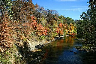
The Vermilion River is a river in northern Ohio in the United States. It is 66.9 miles (107.7 km) long and is a tributary of Lake Erie, draining an area of 268 square miles (690 km2). The name alludes to the reddish clay that is the predominant local soil along its route. The river is commonly muddy after rains.

The Vermilion River is a 70.0-mile-long (112.7 km) bayou in southern Louisiana in the United States. It is formed on the common boundary of Lafayette and St. Martin parishes by a confluence of small bayous flowing from St. Landry Parish, and flows generally southward through Lafayette and Vermilion parishes, past the cities of Lafayette and Abbeville. At the port of Intracoastal City, the Gulf Intracoastal Waterway crosses the river before the latter flows into Vermilion Bay, an inlet of the Gulf of Mexico. The river originates at Bayou Fusilier, which is fed by Bayou Teche; winds its way through Lafayette Parish; and drains into the Vermilion Bay below Vermilion Parish.

The Vermilion River is a 74.8-mile-long (120.4 km) tributary of the Illinois River in the state of Illinois, United States. The river flows north, in contrast to a second Vermilion River in Illinois, which flows south to the Wabash River. The Illinois and Wabash rivers each have a tributary named the Little Vermilion River as well.
The Little Vermilion River is a 59.6-mile-long (95.9 km) tributary of the Wabash River. The Little Vermilion rises in southern Vermilion County, Illinois, flowing eastward past Georgetown, Illinois, into Vermillion County, Indiana, where it joins the Wabash near Newport.

The Middle Fork of the Vermilion River is a tributary of the Vermilion River in Illinois. The Middle Fork rises in Ford County and flows southeast to join the Vermilion near Danville.
The Salt Fork is a tributary of the Vermilion River located in the Central Corn Belt Plains of Illinois.
The Little Vermilion River is a 34.7-mile-long (55.8 km) tributary of the Illinois River, which it joins near LaSalle, Illinois, opposite the north-flowing Vermilion River. There is another "Little Vermilion River" in Illinois which is a tributary of the Wabash River.

The Nicemodel is a scenario for the dynamical evolution of the Solar System. It is named for the location of the Observatoire de la Côte d'Azur — where it was initially developed in 2005 — in Nice, France. It proposes the migration of the giant planets from an initial compact configuration into their present positions, long after the dissipation of the initial protoplanetary disk. In this way, it differs from earlier models of the Solar System's formation. This planetary migration is used in dynamical simulations of the Solar System to explain historical events including the Late Heavy Bombardment of the inner Solar System, the formation of the Oort cloud, and the existence of populations of small Solar System bodies such as the Kuiper belt, the Neptune and Jupiter trojans, and the numerous resonant trans-Neptunian objects dominated by Neptune.

The Algoman orogeny, known as the Kenoran orogeny in Canada, was an episode of mountain-building (orogeny) during the Late Archean Eon that involved repeated episodes of continental collisions, compressions and subductions. The Superior province and the Minnesota River Valley terrane collided about 2,700 to 2,500 million years ago. The collision folded the Earth's crust and produced enough heat and pressure to metamorphose the rock. Blocks were added to the Superior province along a 1,200 km (750 mi) boundary that stretches from present-day eastern South Dakota into the Lake Huron area. The Algoman orogeny brought the Archaen Eon to a close, about 2,500 million years ago; it lasted less than 100 million years and marks a major change in the development of the Earth's crust.

The Late Heavy Bombardment (LHB), or lunar cataclysm, is a hypothesized event thought to have occurred approximately 4.1 to 3.8 billion years (Ga) ago, at a time corresponding to the Neohadean and Eoarchean eras on Earth. During this interval, a disproportionately large number of asteroids are theorized to have collided with the early terrestrial planets in the inner Solar System, including Mercury, Venus, Earth and Mars. Since 2018, the existence of the Late Heavy Bombardment has been questioned.
The five-planet Nice model is a recent variation of the Nice model that begins with five giant planets, the four plus an additional ice giant in a chain of mean-motion resonances.

The E-belt asteroids were the population of a hypothetical extension of the primordial asteroid belt proposed as the source of most of the basin-forming lunar impacts during the Late Heavy Bombardment.