Related Research Articles
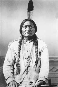
The Lakota are a Native American people. Also known as the Teton Sioux, they are one of the three prominent subcultures of the Sioux people, with the Eastern Dakota (Santee) and Western Dakota (Wičhíyena). Their current lands are in North and South Dakota. They speak Lakȟótiyapi—the Lakota language, the westernmost of three closely related languages that belong to the Siouan language family.

Union County is the southernmost county in the U.S. state of South Dakota. As of the 2020 census, the population was 16,811, making it the 13th most populous county in South Dakota. Its county seat has been Elk Point since April 30, 1865. Originally named Cole County, its name was changed to Union on January 7, 1864, because of Civil War sentiment.

Stanley County is a county in the U.S. state of South Dakota. As of the 2020 census, the population was 2,980. Its county seat is Fort Pierre. The county was created in 1873, and was organized in 1890. It is named for David S. Stanley, a commander at Fort Sully from 1866 to 1874, which was located nearby.

Lyman County is a county located in the U.S. state of South Dakota. As of the 2020 census, the population was 3,718. Its county seat is Kennebec.

Brule County is a county in the U.S. state of South Dakota. As of the 2020 census, the population was 5,247. Its county seat is Chamberlain.
The Big Sioux River is a tributary of the Missouri River in eastern South Dakota and northwestern Iowa in the United States. It flows generally southwardly for 419 mi (674 km), and its watershed is 9,006 sq mi (23,330 km2). The United States Board on Geographic Names settled on "Big Sioux River" as the stream's name in 1931. The river was named after the Lakota people which was known by them as Tehankasandata, or Thick Wooded River.
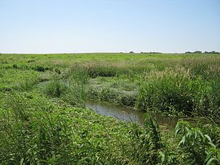
Rowena is an unincorporated community and a census-designated place (CDP) in Minnehaha County, South Dakota, United States. The population of the CDP was 68 at the 2020 census. It is located along South Dakota Highway 42.

The Rosebud Indian Reservation is an Indian reservation in South Dakota, United States. It is the home of the federally recognized Rosebud Sioux Tribe, who are Sicangu, a band of Lakota people. The Lakota name Sicangu Oyate translates as the "Burnt Thigh Nation", also known by the French term, the Brulé Sioux.
There are over a dozen lakes named Mud Lake within the U.S. state of South Dakota. According to the Federal Writers' Project, these lakes were so named on account of the muddy condition of the lake bed or lake shore.

The Santee Sioux Reservation of the Santee Sioux was established in 1863 in present-day Nebraska. The tribal seat of government is located in Niobrara, Nebraska, with reservation lands in Knox County.
The Dakota are a Native American tribe and First Nations band government in North America. They compose two of the three main subcultures of the Sioux people, and are typically divided into the Eastern Dakota and the Western Dakota.
Broken Kettle Creek is a 25-mile-long (40 km) stream in Plymouth County, Iowa. It is a tributary of the Big Sioux River. The creek rises in Preston Township, flows generally south by southwest, and meets the Big Sioux River in Hancock Township, approximately three miles northeast of Jefferson, South Dakota.
Spirit Mound Creek is a tributary of the Vermillion River, located in the southeastern South Dakota county of Clay. It passes through the Spirit Mound Historic Prairie.
Lyonville is an unincorporated community in Brule County, in the U.S. state of South Dakota.
Stevens is an extinct town in Union County, in the U.S. state of South Dakota.
Bachelor Creek is a stream in the U.S. state of South Dakota.
Cobb Creek is a stream in the U.S. states of Minnesota and South Dakota. It is a tributary of the Lac qui Parle River.
Hidewood Creek is a stream in the U.S. state of South Dakota.
No Moccasin Creek is a tributary of the White River in Tripp County, South Dakota, United States. It intersects the off-reservation trust land of the Rosebud Indian Reservation and terminates about 1.9 miles north of Hamill, South Dakota.
Union Creek is a stream in the U.S. state of South Dakota.
References
- ↑ U.S. Geological Survey Geographic Names Information System: Brule Creek
- ↑ Federal Writers' Project (1940). South Dakota place-names, v.3. University of South Dakota. p. 16.
42°48′08″N96°41′10″W / 42.802096°N 96.686034°W
| | This article related to a river in South Dakota is a stub. You can help Wikipedia by expanding it. |