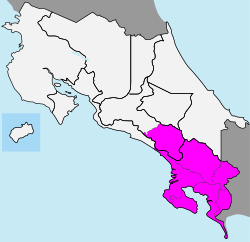
The area of the Brunca Region is 9,528 square kilometers (3,679 square miles). As of 1997, the region was estimated to have a population of 320,863 people.[1]
The name "Brunca" comes from the Brunca people, who are indigenous to Costa Rica.
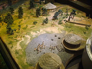
The first indigenous peoples of Costa Rica were hunters and gatherers, and when the Spanish conquerors arrived, Costa Rica was divided in two distinct cultural areas due to its geographical location in the Intermediate Area, between Mesoamerican and the Andean cultures, with influences of both cultures.
Central America is a subregion of the Americas. Its political boundaries are defined as bordering Mexico to the north, Colombia to the south, the Caribbean Sea to the east, and the Pacific Ocean to the west. Central America usually consists of seven countries: Belize, k, Nicaragua, and Panama. Southern Mexico is sometimes also included. Within Central America is the Mesoamerican biodiversity hotspot, which extends from northern Guatemala to central Panama. Due to the presence of several active geologic faults and the Central America Volcanic Arc, there is a high amount of seismic activity in the region, such as volcanic eruptions and earthquakes which has resulted in death, injury, and property damage.
San José is the capital and largest city of Costa Rica, and the capital of the province of the same name. It is in the center of the country, in the mid-west of the Central Valley, within San José Canton. San José is Costa Rica's seat of national government, focal point of political and economic activity, and major transportation hub. San José Canton's population was 288,054 in 2011, and San José's municipal land area is 44.2 square kilometers, with an estimated 333,980 residents in 2015. Together with several other cantons of the central valley, including Alajuela, Heredia and Cartago, it forms the country's Greater Metropolitan Area, with an estimated population of over 2 million in 2017. The city is named in honor of Joseph of Nazareth.
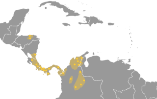
The Chibchan languages make up a language family indigenous to the Isthmo-Colombian Area, which extends from eastern Honduras to northern Colombia and includes populations of these countries as well as Nicaragua, Costa Rica, and Panama. The name is derived from the name of an extinct language called Chibcha or Muysccubun, once spoken by the people who lived on the Altiplano Cundiboyacense of which the city of Bogotá was the southern capital at the time of the Spanish Conquista. However, genetic and linguistic data now indicate that the original heart of Chibchan languages and Chibchan-speaking peoples might not have been in Colombia, but in the area of the Costa Rica-Panama border, where the greatest variety of Chibchan languages has been identified.
The national flag of Costa Rica is based on a design created in 1848 and consists of two blue stripes, two white stripes, and a central red stripe which is twice as wide as each of the other four. The civil flag omits the coat of arms seen on the state flag, since the state variant is only permitted to be used by the government.
According to Article 168 of the Constitution of Costa Rica, the political divisions are officially classified into 3 tiers of sub-national entities.
Guanacaste is a province of Costa Rica located in the northwestern region of the country, along the coast of the Pacific Ocean. It is bordered by Nicaragua to the north, Alajuela Province to the east, and Puntarenas Province to the southeast. It is the most sparsely populated of all the provinces of Costa Rica. The province covers an area of 10,141 square kilometres (3,915 sq mi) and as of 2010, had a population of 354,154, with annual revenue of $2 million.
Puntarenas is a province of Costa Rica. It is located in the western part of the country, covering most of Costa Rica's Pacific Ocean coast, and it is the largest province in Costa Rica. Clockwise from the northwest it borders on the provinces Guanacaste, Alajuela, San José and Limón, and the neighbouring country of Panama.
UNAPROA was founded by deputies of six village communities in the Brunca Region in the year 1995. This association has the ambition of promoting the organic agriculture and green tourism. Its domicile is situated in El General in Costa Rica. The members are mostly campesinos, who husband small fields at the Talamanca mountains. Meanwhile the community has grown and now embraces deputies of forty villages, one of them indigenous. UNAPROA has cooperated for several years with the Austrian magazine Grünen Bildungswerkstatt.
The Asociación de Guías y Scouts de Costa Rica is the national Scouting and Guiding association of Costa Rica. Scouting was founded in Costa Rica in 1915 and became a member of the World Organization of the Scout Movement in 1935. Guiding started in 1922 and became a member of the World Association of Girl Guides and Girl Scouts in 1946. The association has more than 14,500 members of both genders.
The Boruca are the indigenous people living in Costa Rica. The tribe has about 2,660 members, most living on a reservation in the Puntarenas Province in southwestern Costa Rica, a few miles away from the Pan-American Highway following the Rio Terraba. The ancestors of the modern Boruca made up a group of chiefdoms that ruled most of Costa Rica's Pacific coast, from Quepos to what is now the Panamanian border, including the Osa Peninsula. Boruca traditionally spoke the Boruca language, which is now nearly extinct.
The following outline is provided as an overview of and topical guide to Costa Rica:
ISO 3166-2:CR is the entry for Costa Rica in ISO 3166-2, part of the ISO 3166 standard published by the International Organization for Standardization (ISO), which defines codes for the names of the principal subdivisions of all countries coded in ISO 3166-1.
Coffee production has played a key role in Costa Rica's history and continues to be important to the country's economy. In 2006, coffee was Costa Rica's number three export, after being the number one cash crop export for several decades. In 1997, the agriculture sector employed 28 percent of the labor force and comprised 20 percent of Costa Rica's total GNP. Production increased from 158,000 tons in 1988 to 168,000 tons in 1992. The largest growing areas are in the provinces of San José, Alajuela, Heredia, Puntarenas, and Cartago. The coffee is exported to other countries in the world and is also exported to cities in Costa Rica.
The following is an alphabetical list of topics related to the Republic of Costa Rica.
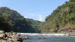
Térraba River, in the southern Brunca region of Costa Rica, is the largest river in that country.
Brunca Sign Language is a village sign language of an indigenous Brunca community in southern Costa Rica. It is unrelated to Costa Rican Sign Language.
San Isidro de El General is the first district of the canton of Pérez Zeledón, in the southern part of the province of San José in Costa Rica, as well as the name of said district's main city.
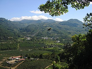
Brunca is one of six socioeconomic regions of Costa Rica.
Paso Canoas is an international city shared between Puntarenas Province in Costa Rica and Chiriquí Province in the west of Panama. The border between Costa Rica and Panama crosses Paso Canoas from north to south, with the result that the city is both Costa Rican and Panamanian.
This page is based on this Wikipedia article Text is available under the CC BY-SA 4.0 license; additional terms may apply. Images, videos and audio are available under their respective licenses.