
Morgedal is a village in Kviteseid Municipality in Telemark county, Norway. The village is located in the mountains along the European route E134 highway, about 6 kilometres (3.7 mi) to the northwest of the village of Brunkeberg and about 9 kilometres (5.6 mi) to the northwest of the village of Kviteseid.
Kviteseid is a municipality in Telemark county, Norway. It is located in the traditional districts of Vest-Telemark and Upper Telemark. The administrative centre of the municipality is the village of Kviteseidbyen. Other villages in Kviteseid include Åsgrend, Brunkeberg, Eidstod, Fjågesund, Kilen, Morgedal, and Vrådal.

Flåbygd is a village in Nome Municipality in Telemark county, Norway. The village is located at the eastern end of the lake Flåvatn. The village of Bjervamoen lies about 10 kilometres (6.2 mi) to the east and the village of Kilen is located about 15 kilometres (9.3 mi) to the west. Flåbygd Church is located in the village. The local economy is centered on agriculture.

European route E134 is a European highway that crosses Norway starting at Haugesund Airport, Karmøy near the city of Haugesund on the west coast, heading over Haukeli, passing the city of Drammen, and ending in Vassum on the east side of the Oslofjord Tunnel.
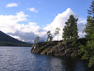
Nisser is a lake in Telemark county, Norway. It is located in Nissedal and Kviteseid municipalities, and is Telemark's largest lake. The lake is the 10th-largest lake in the nation by area with a surface area of 76.07 km2 (29.37 sq mi). The 8th largest by volume at 7.074 km3 (1.697 cu mi). The 16th deepest at 234 m (768 ft). Nisser has the greatest average depth of the norwegian lakes; who isn't a cryptodepression. It's whole lakebasin is over the sealevel. As part of the Arendal watershed, water enters this lake from the discharge from the nearby lake Vråvatn, and its outlet is the Nisserelva river which later becomes part of the river Nidelva.
Åsgrend is a rural village in Kviteseid Municipality in Telemark county, Norway. The village is located in the northeastern part of the municipality, about 5 kilometres (3.1 mi) east of the village of Brunkeberg. The European route E134 highway passes just to the northwest of the village.
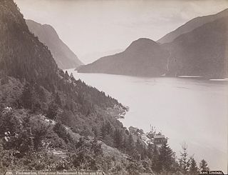
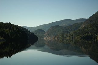
Bandak is a lake in the municipalities of Kviteseid and Tokke in Telemark county, Norway. The lake, which is part of the Telemark Canal route, belongs to the Skien watershed. The river Tokke flows into the lake, and the outlet is via the river Strauman, which flows to the lake Kviteseidvatn.
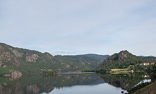
Kviteseidvatn or Kviteseidvatnet is a lake in the municipality of Kviteseid in Telemark county, Norway. The 15.76-square-kilometre (6.08 sq mi) lake is part of the Telemark Canal and lies in the Skien watershed. The lake's water level was first regulated in 1892.
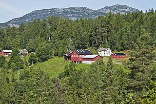
Vrådal is a village area in Kviteseid Municipality in Telemark county, Norway. The village is located along the northern end of the lake Nisser and the eastern end of the lake Vråvatn. The economy is based on tourism, light industry, and small-scale logging. The wooden Vrådal Church, built in 1866, is located on the western end of the village. Vrådal is located about 10 kilometres (6.2 mi) to the south of the village of Kviteseid.

Eidstod is a village in Kviteseid Municipality in Telemark county, Norway. The village is located at the northern end of the lake Nisser and it is the main population centre in the Vrådal area. The Norwegian National Road 41 runs along the eastern side of the village. The village of Kviteseid is located about 10 kilometres (6.2 mi) to the north and the village of Fjågesund lies about 15 kilometres (9.3 mi) to the east.

Norwegian National Road 41 is a Norwegian national road that runs through Telemark and Agder counties in Norway. The road runs between the village of Brunkeberg in Kviteseid municipality in Telemark county in the north and Timenes in Hånes in the city of Kristiansand in Agder county in the south. The 172.9-kilometre (107.4 mi) long road connects to the European route E134 highway in the north and to the European route E18 highway in the south. The road runs for 101.5 kilometres (63.1 mi) in Agder county and 71.4 kilometres (44.4 mi) in Telemark county. The southern half of the road runs along the river Tovdalselva and the lake Herefossfjorden, and it is located in a fault zone called the Kristiansand-Porsgrunn grabenen.

Old Kviteseid Church is a parish church of the Church of Norway in Kviteseid Municipality in Telemark county, Norway. It is located about 4 kilometres (2.5 mi) north of the village of Eidstod. It is one of the churches in the Kviteseid parish which is part of the Øvre Telemark prosti (deanery) in the Diocese of Agder og Telemark. The white, stone church was built in a long church design around the year 1260 using plans drawn up by an unknown architect. The church seats about 150 people. This is among the better preserved stone churches in Telemark.

Kviteseid Church is a parish church of the Church of Norway in Kviteseid Municipality in Telemark county, Norway. It is located in the village of Kviteseid. It is the main church for the Kviteseid parish which is part of the Øvre Telemark prosti (deanery) in the Diocese of Agder og Telemark. The brown, stone church was built in a long church design in 1915 using plans drawn up by the architect Haldor Larsen Børve. The church seats about 320 people.
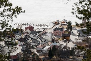
Kviteseid or Kviteseidbyen is the administrative centre of Kviteseid Municipality in Telemark county, Norway. The village is located at the north end of the Sundkilen lake, an extension off of the main Kviteseidvatnet lake. The village of Brunkeberg lies about 5 kilometres (3.1 mi) to the north, the village of Vrådal lies about 10 kilometres (6.2 mi) to the south, and the village of Fjågesund lies about 20 kilometres (12 mi) to the southeast.
Vrådal Church is a parish church of the Church of Norway in Kviteseid Municipality in Telemark county, Norway. It is located in the village of Vrådal. It is one of the churches in the Kviteseid parish which is part of the Øvre Telemark prosti (deanery) in the Diocese of Agder og Telemark. The white, wooden church was built in a long church design in 1887 using plans drawn up by the architect Christian Grosch. The church seats about 170 people.

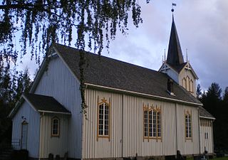
Fjågesund Church is a parish church of the Church of Norway in Kviteseid Municipality in Telemark county, Norway. It is located in the village of Fjågasund. It is one of the churches in the Kviteseid parish which is part of the Øvre Telemark prosti (deanery) in the Diocese of Agder og Telemark. The brown, wooden church was built in a long church design in 1916 using plans drawn up by the architect Haldor Larsen Børve. The church seats about 108 people.
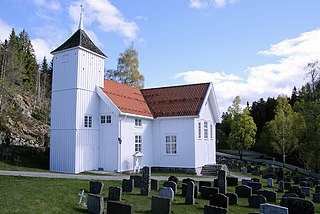
Brunkeberg Church is a parish church of the Church of Norway in Kviteseid Municipality in Telemark county, Norway. It is located in the village of Brunkeberg. It is one of the churches in the Kviteseid parish which is part of the Øvre Telemark prosti (deanery) in the Diocese of Agder og Telemark. The white, wooden church was built in a cruciform design in 1790 by the builder Saamund Gjersund. The church seats about 300 people.
Fjågesund is a village in Kviteseid Municipality in Telemark county, Norway. The village is located at the west end of the lake Flåvatn and the southeastern end of the lake Kviteseidvatnet, about mid-way along the Telemark Canal. It is located about 10 kilometres (6.2 mi) to the southwest of the village of Kilen and about 20 kilometres (12 mi) to the southeast of the village of Kviteseidbyen.
Kilen is a village in Kviteseid Municipality in Telemark county, Norway. The village is located on a small bay on the north side of the large lake Flåvatn. It is located about 20 kilometres (12 mi) to the southeast of Kviteseidbyen and about 20 kilometres (12 mi) to the south of the village of Seljord.


