Brunswick Progress Association

Last updated

The Brunswick Progress Association is a community organisation active in the City of Merri-bek Council area, and in particular the suburbs of Brunswick and Coburg, inner northern suburbs of Melbourne, Victoria, Australia. It was first established in 1905 and celebrated its centenary of community activism in 2005.

History

The movement to form a Town Association (Progress) began early in 1905 in reaction to the non-responsiveness of the Brunswick Council to the concerns of residents. It was the first such body established in the Melbourne metropolitan area. It is likely the Brunswick Progress Association was the second one established in Australia, as a progress association was established at Ballarat in 1904.

Australian Labor Party State Member of Parliament, and later Federal member for the seat of Bourke, Frank Anstey (1865-1940), was elected on the first Executive Committee of the Brunswick Town Association (Progress). Anstey had a long association with the organisation until his death in 1940. Maurice Blackburn succeeded Frank Anstey as Federal representative for the seat of Bourke and also maintained an active interest in the affairs of the Brunswick Progress Association.

In the cold war atmosphere of 1953 the Brunswick Council passed a resolution not to enter into any correspondence with any person who is a communist or communist sympathiser. In council elections in 1954 the Mayor and several councillors were defeated and in a meeting of Council the 'Anti-red law' was rescinded 18 votes to 4.

In 1965 the Progress Association was at a low ebb of activity. Two new members, Vic Little and Vida Little, enlivened the organisation, which steadily grew in members as campaigns were launched on local issues and concerns of residents.

In the 1960s and 1970s, the Association was very active in opposition to the proposed F2 Freeway along the Merri Creek, ran a successful campaign for clean air, as Brunswick was then said to be the second most polluted city in Victoria. The clean air campaign in the 1960s was instrumental in establishing the Victorian Environment Protection Authority in 1972.

In 1971 the Brunswick Progress Association combined with the West Brunswick Progress Association to object significantly to council plans to demolish the Mechanics' Institute, which was built in 1868. The National Trust also objected and the Mechanics' Institute was saved from the wreckers.

In 1973, the Association was active in opposing council plans to demolish the Brunswick Town Hall on Sydney Road and replace it with a five story Civic Centre, costing in excess of $2 million. The Council plans were stopped with a poll of residents resulting in a no vote won by seven to one.

In 1975 the Brunswick Progress Association instituted a campaign to get a Community Health Centre complex, the Brunswick City Council opposed it, the Centre was won with wide support from the community. The Merri-bek Community Health Service is now a multimillion-dollar community organisation servicing the health needs of the residents of the City of Merri-bek, with major centres on Glenlyon Road in Brunswick, and Bell street in Coburg.

Other campaigns included:

The Association meets at the Clarrie Wohlers Citizens' Centre, Fleming Park, on the corner of Albert and Cross Streets, East Brunswick. All residents are welcome to attend.

Related Research Articles

<span class="mw-page-title-main">City of Merri-bek</span> Local government area in Victoria, Australia

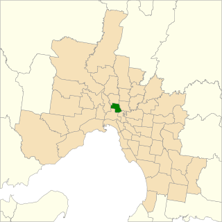
The City of Merri-bek is a local government area in metropolitan Melbourne, Australia. It comprises the inner northern suburbs between 4 and 11 kilometres from the Melbourne CBD. The Merri-bek local government area covers 51 km2 (20 sq mi), and in June 2018, it had a population of 181,725.

<span class="mw-page-title-main">Fitzroy North, Victoria</span> Suburb of Melbourne, Victoria, Australia

Fitzroy North is an inner-city suburb in Melbourne, Victoria, Australia, 4 km (2.5 mi) north-east of Melbourne's Central Business District, located within the Cities of Merri-bek and Yarra local government areas. Fitzroy North recorded a population of 12,781 at the 2021 census.

<span class="mw-page-title-main">Brunswick, Victoria</span> Suburb of Melbourne, Victoria, Australia

Brunswick is an inner-city suburb in Melbourne, Victoria, Australia, 5 km (3.1 mi) north of Melbourne's Central Business District, located within the City of Merri-bek local government area. Brunswick recorded a population of 24,896 at the 2021 census.

<span class="mw-page-title-main">Coburg, Victoria</span> Suburb of Melbourne, Victoria, Australia

Coburg is a suburb in Melbourne, Victoria, Australia, 8 km (5.0 mi) north of Melbourne's Central Business District, located within the Cities of Darebin and Merri-bek local government areas. Coburg recorded a population of 26,574 at the 2021 census.

<span class="mw-page-title-main">Fawkner, Victoria</span> Suburb of Melbourne, Victoria, Australia

Fawkner is a suburb in Melbourne, Victoria, Australia, 12 km (7.5 mi) north of Melbourne's Central Business District, located within the Cities of Hume and Merri-bek local government areas. Fawkner recorded a population of 14,274 at the 2021 census.

<span class="mw-page-title-main">Pascoe Vale, Victoria</span> Suburb of Melbourne, Victoria, Australia

Pascoe Vale is a suburb in Melbourne, Victoria, Australia, 9 km (5.6 mi) north of Melbourne's Central Business District, located within the City of Merri-bek local government area. Pascoe Vale recorded a population of 18,171 at the 2021 census.

<span class="mw-page-title-main">Upfield Bike Path</span>

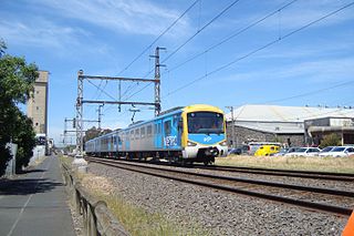
The Upfield Shared Path is a shared use path for cyclists and pedestrians, which follows Upfield railway line through the inner northern suburbs of Melbourne, Victoria, Australia.

<span class="mw-page-title-main">Coburg North, Victoria</span> Suburb of Melbourne, Victoria, Australia

Coburg North is a suburb in Melbourne, Victoria, Australia, 9 km (5.6 mi) north of Melbourne's Central Business District, located within the Cities of Darebin and Merri-bek local government areas. Coburg North recorded a population of 8,327 at the 2021 census.

<span class="mw-page-title-main">Sydney Road</span> Road in Melbourne, Australia

Sydney Road is a major urban arterial in the northern suburbs of Melbourne, Victoria, Australia.

<span class="mw-page-title-main">Brunswick East, Victoria</span> Suburb of Melbourne, Victoria, Australia

Brunswick East is an inner-city suburb in Melbourne, Victoria, Australia, 5 km (3.1 mi) north of Melbourne's Central Business District, located within the City of Merri-bek local government area. Brunswick East recorded a population of 13,279 at the 2021 census.

<span class="mw-page-title-main">Brunswick West, Victoria</span> Suburb of Melbourne, Victoria, Australia

Brunswick West is an inner-city suburb in Melbourne, Victoria, Australia, 6 km (3.7 mi) north of Melbourne's Central Business district, located within the City of Merri-bek local government area. Brunswick West recorded a population of 14,746 at the 2021 census.

<span class="mw-page-title-main">Hadfield, Victoria</span> Suburb of Melbourne, Victoria, Australia

Hadfield is a suburb in Melbourne, Victoria, Australia, 12 km (7.5 mi) north of Melbourne's Central Business District, located within the City of Merri-bek local government area. Hadfield recorded a population of 6,269 at the 2021 census.

<span class="mw-page-title-main">Brunswick Town Hall</span>

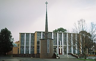
Brunswick Town Hall is located on the corner of Sydney Road and Dawson Street in the inner northern Melbourne suburb of Brunswick, Victoria, Australia.

<span class="mw-page-title-main">Division of Wills</span> Australian federal electoral division

The Division of Wills is an Australian electoral division of Victoria. It is currently represented by Peter Khalil of the Australian Labor Party.

<span class="mw-page-title-main">Coburg City Oval</span>

Coburg City Oval is an Australian rules football and cricket stadium located in Coburg, Australia. It is home to the Coburg Football Club in the Victorian Football League, and the Coburg Cricket Club.

<span class="mw-page-title-main">Electoral district of Brunswick</span>

The electoral district of Brunswick is an electorate of the Victorian Legislative Assembly. It covers an area of 14 square kilometres (5.4 sq mi) in inner northern Melbourne, and includes the suburbs of Brunswick, Brunswick East, Carlton North, Fitzroy North, Princes Hill and parts of Brunswick West. It lies within the Northern Metropolitan Region of the upper house, the Legislative Council.

<span class="mw-page-title-main">City of Brunswick</span> Local government area in Victoria, Australia

The City of Brunswick was a local government area in the inner-northern suburbs of Melbourne, Victoria, Australia. It comprised the suburbs of Brunswick, Brunswick East and West Brunswick. It ceased to exist on 22 June 1994, when its council was disbanded by the Kennett Government and replaced with appointed commissioners, who oversaw its amalgamation with the City of Coburg and parts of the City of Broadmeadows, to create the City of Moreland.

<span class="mw-page-title-main">City of Coburg</span> Local government area in Victoria, Australia

The City of Coburg was a local government area about 10 kilometres (6 mi) north of Melbourne, the state capital of Victoria, Australia. The city covered an area of 19.44 square kilometres (7.51 sq mi), and existed from 1859 until 1994.

<span class="mw-page-title-main">MoreArt</span>

MoreArt is an annual art in public spaces event along the Upfield Bike Path, the adjacent railway corridor and Sydney Road. Presented by the City of Merri-bek, the first event was held in 2010.

References