
Holy Island is an island on the western side of the larger Isle of Anglesey, Wales, from which it is separated by the Cymyran Strait. It is called "Holy" because of the high concentration of standing stones, burial chambers, and other religious sites on the small island. The alternative English name of the island is Holyhead Island. According to the 2011 UK Census, the population was 13,659, of whom 11,431 (84%) lived in the largest town, Holyhead.
Flag Fen, east of Peterborough, England, is a Bronze Age site which was constructed about 3500 years ago and consists of more than 60,000 timbers arranged in five very long rows, creating a wooden causeway across the wet fenland. Part-way across the structure a small island was formed. Items associated with it have led scholars to conclude that the island was of religious significance. Archaeological work began in 1982 at the site, which is located 800 m east of Fengate. Flag Fen is now part of the Greater Fens Museum Partnership. A visitor centre has been constructed on site and some areas have been reconstructed, including a typical Iron Age roundhouse dwelling.

Bryn Celli Ddu is a prehistoric site on the Welsh island of Anglesey located near Llanddaniel Fab. Its name means 'the mound in the dark grove'. It was archaeologically excavated between 1928 and 1929. Visitors can get inside the mound through a stone passage to the burial chamber, and it is the centrepiece of a major Neolithic Scheduled Monument in the care of Cadw. The presence of a mysterious pillar within the burial chamber, the reproduction of the 'Pattern Stone', carved with sinuous serpentine designs, and the fact that the site was once a henge with a stone circle, and may have been used to plot the date of the summer solstice have all attracted much interest.

Aberffraw is a village and community on the south west coast of the Isle of Anglesey in Wales. The village is 9 miles from the island's capital, Llangefni, and is located is on the west bank of the Afon Ffraw. The community includes Soar and Dothan. Located near the A4080 and the nearest rail station is Bodorgan.

Ynys Llanddwyn is a small tidal island off the west coast of Anglesey, northwest Wales. The nearest settlement is the village of Newborough.

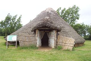
A roundhouse is a type of house with a circular plan, usually with a conical roof. In the later part of the 20th century, modern designs of roundhouse eco-buildings were constructed with materials such as cob, cordwood or straw bale walls and reciprocal frame green roofs.
St Fagans National Museum of History, commonly referred to as St Fagans after the village where it is located, is an open-air museum in Cardiff chronicling the historical lifestyle, culture, and architecture of the Welsh people. The museum is part of the wider network of Amgueddfa Cymru – Museum Wales.

Sir Cyril Fred Fox was an English archaeologist and museum director.

Melin Llynon, or Llynon Mill, is a gristmill located on the outskirts of the village of Llanddeusant on the island of Anglesey. It is the only surviving working windmill in Wales.

Prehistoric Wales in terms of human settlements covers the period from about 230,000 years ago, the date attributed to the earliest human remains found in what is now Wales, to the year AD 48 when the Roman army began a military campaign against one of the Welsh tribes. Traditionally, historians have believed that successive waves of immigrants brought different cultures into the area, largely replacing the previous inhabitants, with the last wave of immigrants being the Celts. However, studies of population genetics now suggest that this may not be true, and that immigration was on a smaller scale.

Dinas Dinlle is a small settlement in Gwynedd, north-west Wales which is also, historically, part of Caernarfonshire.
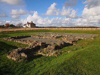
Llys Rhosyr, also known as "Cae Llys", is an archaeological site near Newborough in Anglesey; the ruins of a pre-Edwardian commotal court.

Llanidan is a community in the south of Anglesey, Wales which includes the village of Brynsiencyn. The parish is along the Menai Strait, about 4 miles north-east of Caernarfon. The parish church of St Nidan is near the A4080 highway, a little to the east of Brynsiencyn. The ruins of an earlier parish church survive.

Llansadwrn is a small village in the community of Cwm Cadnant in south-east Anglesey, in north-west Wales. It lies between Menai Bridge, Pentraeth and Beaumaris. It is named after the church, founded in the 6th century by Saint Saturninus, who together with his wife, is commemorated by an early Christian monument.

The Holyhead Mountain Hut Circles named in Welsh: Tŷ Mawr / Cytiau'r Gwyddelod, literally meaning Big house or "Irishmen's Huts". are the remains of a group of Celtic Iron Age huts near Trearddur on Holy Island, Anglesey, Wales. The site is under the care of Cadw and can be visited all year round. The construction of these huts is very similar to those at Din Lligwy, having thick stone walls.

The Isle of Anglesey is a county off the north-west coast of Wales. It is named after the island of Anglesey, which makes up 94% of its area, but also includes Holy Island and some islets and skerries. The county borders Gwynedd across the Menai Strait to the southeast, and is otherwise surrounded by the Irish Sea. Holyhead is the largest town, and the administrative centre is Llangefni. The county is part of the preserved county of Gwynedd.

Burrough Hill is an Iron Age hillfort in Burrough on the Hill, 7 miles (11 km) south of Melton Mowbray in the English county of Leicestershire. Situated on a promontory about 210 metres (690 ft) above sea level, the site commands views over the surrounding countryside for miles around. There has been human activity in the area since at least the Mesolithic, and the hillfort was founded in the early Iron Age. In the medieval period, after the hillfort was abandoned, the hill was used as farmland. This ended in the 17th century when the parish the hill was in was enclosed. Traces of ridge and furrow show where the medieval fields were ploughed. Since the 1930s the site has been the subject of archaeological investigations and renewed excavations under the auspices of the University of Leicester began in 2010. Part of Burrough Hill Country Park and open to the public, the hillfort is protected as a Scheduled Ancient Monument.

In archaeology, a hut circle is a circular or oval depression in the ground which may or may not have a low stone wall around it that used to be the foundation of a round house. The superstructure of such a house would have been made of timber and thatch. They are numerous in parts of upland Britain and most date to around the 2nd century BC.

Parciau hill fort is a hill fort on the Welsh island of Anglesey. It stands on the summit of Bryn Ddiôl, whose name means "trackless hill".
The archaeology of Wales is the study of human occupation within the country of Wales which has been occupied by modern humans since 225,000 BCE, with continuous occupation from 9,000 BCE. Analysis of the sites, artefacts and other archaeological data within Wales details its complex social landscape and evolution from Prehistoric times to the Industrial period. This study is undertaken by academic institutions, consultancies, charities as well as government organisations.

