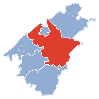
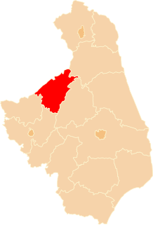
Białaszewo is a village in the administrative district of Gmina Grajewo, within Grajewo County, Podlaskie Voivodeship, in north-eastern Poland. It lies approximately 16 kilometres (10 mi) south of Grajewo and 62 km (39 mi) north-west of the regional capital Białystok.
Chojnówek is a village in the administrative district of Gmina Grajewo, within Grajewo County, Podlaskie Voivodeship, in north-eastern Poland. It lies approximately 7 kilometres (4 mi) west of Grajewo and 79 km (49 mi) north-west of the regional capital Białystok.
Ciemnoszyje is a village in the administrative district of Gmina Grajewo, within Grajewo County, Podlaskie Voivodeship, in north-eastern Poland. It lies approximately 14 kilometres (9 mi) south-east of Grajewo and 63 km (39 mi) north-west of the regional capital Białystok.
Cyprki is a village in the administrative district of Gmina Grajewo, within Grajewo County, Podlaskie Voivodeship, in north-eastern Poland. It lies approximately 6 kilometres (4 mi) west of Grajewo and 81 km (50 mi) north-west of the regional capital Białystok.
Dybła is a village in the administrative district of Gmina Grajewo, within Grajewo County, Podlaskie Voivodeship, in north-eastern Poland. It lies approximately 8 kilometres (5 mi) south of Grajewo and 72 km (45 mi) north-west of the regional capital Białystok.
Gackie is a village in the administrative district of Gmina Grajewo, within Grajewo County, Podlaskie Voivodeship, in north-eastern Poland. It lies approximately 12 kilometres (7 mi) south of Grajewo and 66 km (41 mi) north-west of the regional capital Białystok.
Kurejewka is a village in the administrative district of Gmina Grajewo, within Grajewo County, Podlaskie Voivodeship, in north-eastern Poland. It lies approximately 8 kilometres (5 mi) south-west of Grajewo and 78 km (48 mi) north-west of the regional capital Białystok.
Kurki is a village in the administrative district of Gmina Grajewo, within Grajewo County, Podlaskie Voivodeship, in north-eastern Poland. It lies approximately 8 kilometres (5 mi) west of Grajewo and 80 km (50 mi) north-west of the regional capital Białystok.
Łękowo is a village in the administrative district of Gmina Grajewo, within Grajewo County, Podlaskie Voivodeship, in north-eastern Poland. It lies approximately 4 kilometres (2 mi) south of Grajewo and 73 km (45 mi) north-west of the regional capital Białystok.
Łojki is a village in the administrative district of Gmina Grajewo, within Grajewo County, Podlaskie Voivodeship, in north-eastern Poland. It lies approximately 12 kilometres (7 mi) south of Grajewo and 66 km (41 mi) north-west of the regional capital Białystok.
Mareckie is a village in the administrative district of Gmina Grajewo, within Grajewo County, Podlaskie Voivodeship, in north-eastern Poland. It lies approximately 8 kilometres (5 mi) south of Grajewo and 71 km (44 mi) north-west of the regional capital Białystok.
Pieniążki is a village in the administrative district of Gmina Grajewo, within Grajewo County, Podlaskie Voivodeship, in north-eastern Poland. It lies approximately 12 kilometres (7 mi) south of Grajewo and 65 km (40 mi) north-west of the regional capital Białystok.
Sienickie is a village in the administrative district of Gmina Grajewo, within Grajewo County, Podlaskie Voivodeship, in north-eastern Poland. It lies approximately 14 kilometres (9 mi) south of Grajewo and 65 km (40 mi) north-west of the regional capital Białystok.
Sojczynek is a village in the administrative district of Gmina Grajewo, within Grajewo County, Podlaskie Voivodeship, in north-eastern Poland. It lies approximately 20 kilometres (12 mi) south of Grajewo and 59 km (37 mi) north-west of the regional capital Białystok.
Toczyłowo is a village in the administrative district of Gmina Grajewo, within Grajewo County, Podlaskie Voivodeship, in north-eastern Poland. It lies approximately 5 kilometres (3 mi) north-east of Grajewo and 78 km (48 mi) north-west of the regional capital Białystok.
Wojewodzin is a village in the administrative district of Gmina Grajewo, within Grajewo County, Podlaskie Voivodeship, in north-eastern Poland. It lies approximately 4 kilometres (2 mi) south of Grajewo and 74 km (46 mi) north-west of the regional capital Białystok.
Zaborowo is a village in the administrative district of Gmina Grajewo, within Grajewo County, Podlaskie Voivodeship, in north-eastern Poland. It lies approximately 17 kilometres (11 mi) south of Grajewo and 65 km (40 mi) north-west of the regional capital Białystok.
Wólka Piotrowska is a village in the administrative district of Gmina Rajgród, within Grajewo County, Podlaskie Voivodeship, in north-eastern Poland. It lies approximately 10 kilometres (6 mi) south-west of Rajgród, 9 km (6 mi) north-east of Grajewo, and 75 km (47 mi) north-west of the regional capital Białystok.
Dołęgi is a village in the administrative district of Gmina Szczuczyn, within Grajewo County, Podlaskie Voivodeship, in north-eastern Poland. It lies approximately 4 kilometres (2 mi) south-west of Szczuczyn, 19 km (12 mi) south-west of Grajewo, and 79 km (49 mi) north-west of the regional capital Białystok.
Niedźwiadna is a village in the administrative district of Gmina Szczuczyn, within Grajewo County, Podlaskie Voivodeship, in north-eastern Poland. It lies approximately 6 kilometres (4 mi) west of Szczuczyn, 20 km (12 mi) south-west of Grajewo, and 81 km (50 mi) north-west of the regional capital Białystok.