
Hardeman County is a county located in the U.S. state of Texas. As of the 2020 census, its population was 3,549. The county seat and largest city is Quanah. The county was created in 1858 and later organized in 1884. It is named for two brothers, Bailey Hardeman and Thomas Jones Hardeman, early Texas politicians and legislators. Hardeman County was one of 46 prohibition or entirely dry counties in the state of Texas until November 2006, when voters approved referendums to permit the legal sale of alcoholic beverages for on- and off-premises consumption.

The Adams–Onís Treaty of 1819, also known as the Transcontinental Treaty, the Spanish Cession, the Florida Purchase Treaty, or the Florida Treaty, was a treaty between the United States and Spain in 1819 that ceded Florida to the U.S. and defined the boundary between the U.S. and Mexico. It settled a standing border dispute between the two countries and was considered a triumph of American diplomacy. It came during the successful Spanish American wars of independence against Spain.
The Washita River is a river in the states of Texas and Oklahoma in the United States. The river is 295 miles (475 km) long and terminates at its confluence with the Red River, which is now part of Lake Texoma on the Texas–Oklahoma border.

Greer County, a county created by the Texas legislature on February 8, 1860, was land claimed by both Texas and the United States. The region of Greer County is now in present-day Oklahoma.

Altus Air Force Base is a United States Air Force base located approximately 4 miles (6.4 km) east-northeast of Altus, Oklahoma.

Noonday Creek is a 20.2-mile-long (32.5 km) stream in Cobb and Cherokee counties in the U.S. state of Georgia. The stream begins near Kennesaw Mountain and ends at Lake Allatoona.
The Chestatee River is a 32.76-mile-long (52.72 km) river in the Appalachian Mountains of northern Georgia, USA.
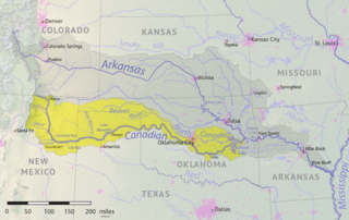
The Beaver River is an intermittent river, 280 miles (450 km) long, in western Oklahoma and northern Texas in the United States. It is a tributary of the North Canadian River, draining an area of 11,690 square miles (30,300 km2) in a watershed that extends to northeastern New Mexico and includes most of the Oklahoma Panhandle.
Sweetwater Creek is a stream in the Texas Panhandle and western Oklahoma. It is a tributary to the North Fork of the Red River.

Pierce Township is one of thirteen townships in Washington County, Indiana, United States. As of the 2020 census, its population was 2,504 and it contained 1,142 housing units.
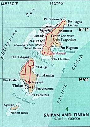
San Jose is the largest village on the island of Tinian, in the Northern Mariana Islands. It is located on the south coast of the island, close to the island's main harbor and three beaches: Kammer Beach, Taga Beach, and Tachogña Beach (Tachungnya).
The Pelican River is a river of Minnesota. It is a tributary of the Vermilion River.

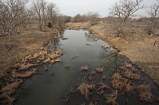
Groesbeck Creek is a stream in Texas which is a tributary of the Red River.
Hubbard Creek is a river that flows through Callahan, Shackelford and Stephens counties in Texas.
The Leona River is a river in Texas. It runs through the counties of Uvalde, Zavala and Frio. Archeological discoveries related to indigenous peoples have been made in areas where the river has drained.
The Sabinal River, formerly Arroyo de la Soledad, is a stream in Uvalde and Bandera counties of the U.S. state of Texas. The upper part of the river runs through the Lost Maples State Natural Area, being fed by Hale, Hollow, and Can Creeks. The Mill, Little, Onion, Rancheros, Nolton, and East Elm Creeks feed in the lower region, where it runs underground in some places. The Sabinal exits into the Frio River about 16 miles south of the city of Sabinal.
Tule Creek is a river in Texas.
Wanderers Creek is a tributary of the Red River in Texas.

The Turtle River is a 17.6-mile-long (28.3 km) tidal river in the vicinity of Brunswick in Glynn County, Georgia. It is the main tributary of the Brunswick River.
Sheep Creek is a geographical place name. With variations, the name is given to hundreds of bodies of water, roads, canals, reservoirs and populated areas in the United States and other countries. It is the name of a tributary to Lockyear Creek in Queensland, Australia, and the name of at least three bodies of water in Canada. The U.S. state of Montana has 85 different locales that bear that name or a derivation. The U.S. state of Idaho has 92 natural and man-made areas that incorporate Sheep Creek into their names. Nature areas that include trails named Sheep Creek can be found in Canada's Yukon Territory, Colorado's Larimer County and in Utah's Bryce Canyon National Park.
