Related Research Articles
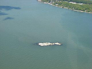
Starve Island is an island of the U.S. state of Ohio located in Lake Erie. The 2-acre (0.81 ha) island is about a mile (1.6 km) south of South Bass Island. In normal weather conditions it is visible for only a mile or two, as some rocks and a few shrubs poking up from the lake, and is the second smallest of the Lake Erie Islands. The island can be seen from the top of Perry's Victory and International Peace Memorial in Put-in-Bay.
Tinker's Creek, in Cuyahoga, Summit and Portage counties of Ohio, is the largest tributary of the Cuyahoga River, providing about a third of its flow into Lake Erie.

Wills Creek is a tributary of the Muskingum River, 92.2 mi (148.4 km) long, in eastern Ohio in the United States. Via the Muskingum and Ohio Rivers, it is part of the watershed of the Mississippi River. It drains an area of 853 mi2 (2,209 km2).
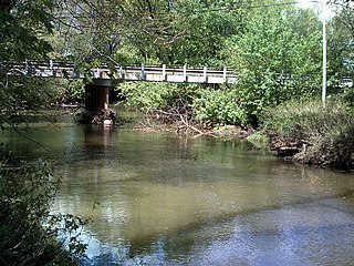
Conotton Creek is a tributary of the Tuscarawas River, 38.7 miles (62.3 km) long, in eastern Ohio in the United States. Via the Tuscarawas, Muskingum and Ohio Rivers, it is part of the watershed of the Mississippi River, draining an area of 286 square miles (741 km²) in Carroll, Harrison and Tuscarawas County, Ohio. The source is at 1240 feet and the mouth is at 874 feet. Dover Dam, downstream on the Tuscarawas river, is normally dry, but can impound a reservoir on Conotton and tributaries to a pool elevation of 916 feet for downstream flood control by the Corps of Engineers. From its source in eastern Harrison County, Ohio the creek flows west northwest through Jewitt, Scio, Conotton, Bowerston, Leesville, Sherrodsville, New Cumberland and Somerdale before reaching its mouth in central Tuscarawas County, Ohio. The Wheeling and Lake Erie Railway is situated in the valley. Ohio State Route 151 runs in the valley from near the source to Bowerston. Ohio State Route 212 run along the valley from Bowerston to the mouth. The Conotton Creek Trail runs from Bowerston to Jewett.

New Cumberland is an unincorporated community in Warren Township, Tuscarawas County, Ohio, United States. The community is served by the Mineral City, Ohio post office, ZIP code 44656. It is located on Conotton Creek, State Route 212 and the Wheeling and Lake Erie Railway.
The Plains of Leon are named for the former gold mining town, Leon once located near the middle of the plain. It is a plain in the Perris Block, contiguous on the south with the Perris Plain including within it the Domenigoni Valley and western Diamond Valley, French Valley, Auld Valley, the upper part of the valley of Warm Springs Creek and connecting tablelands.
Wills Creek is an unincorporated community in Coshocton County, in the U.S. state of Ohio.
Marquand Mills is an extinct town in Muskingum County, in the U.S. state of Ohio.
Barrs Mills is an unincorporated community in Tuscarawas County, in the U.S. state of Ohio.
Oldtown Creek is a stream located entirely within Tuscarawas County, Ohio.
Postboy is an unincorporated community in Tuscarawas County, in the U.S. state of Ohio.
Dunlap Creek is a stream located entirely within Tuscarawas County, Ohio. It is a tributary of the Tuscarawas River.
Honeytown is an unincorporated community in Wooster Township, Wayne County, in the U.S. state of Ohio. Apple Creek flows past the town site.
Newman is an unincorporated community in Stark County, in the U.S. state of Ohio.
Pigeon Run is an unincorporated community in Stark County, in the U.S. state of Ohio.
Sippo is an unincorporated community in Stark County, in the U.S. state of Ohio.
Postboy Creek is a stream in the U.S. state of Ohio. The nearby community of Postboy, Ohio takes its name from the creek.
Cat Creek is a stream in Grundy and Harrison counties in the U.S. state of Missouri. It is a tributary of the Thompson River.
Buckhorn is an unincorporated community in southeastern Madison County, in the U.S. state of Missouri.
Samoa is an unincorporated community in Texas County, in the U.S. state of Missouri.
References
40°16′28″N81°37′36″W / 40.27444°N 81.62667°W
| | This article related to a river in Ohio is a stub. You can help Wikipedia by expanding it. |