
The Arctic Archipelago, also known as the Canadian Arctic Archipelago, is an archipelago lying to the north of the Canadian continental mainland, excluding Greenland and Iceland.

Eliodoro Camacho is a province in the La Paz Department in Bolivia situated at Lake Titicaca. Its seat is Puerto Acosta.
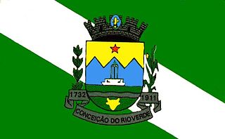
Conceição do Rio Verde is a Brazilian municipality of the state of Minas Gerais. Its population is 13,684.

Tepuka Vili Vili or Tepuka Savilivili is an islet of Funafuti, Tuvalu.

Calzadilla de Tera is a municipality located in the province of Zamora, Castile and León, Spain. According to the 2004 census (INE), the municipality has a population of 467 inhabitants.
Sibelius Glacier is a glacier, 12 miles (19 km) long and 6 miles (10 km) wide, flowing south into the Mozart Ice Piedmont 10 miles (16 km) southwest of Mount Stephenson in the northern portion of Alexander Island, Antarctica. The glacier was first sighted from the air by the British Graham Land Expedition in 1937. Mapped from air photos taken by the Ronne Antarctic Research Expedition in 1947–48, by Searle of the Falkland Islands Dependencies Survey in 1960. This feature was named by the United Kingdom Antarctic Place-Names Committee for Jean Sibelius (1865-1957), Finnish composer.
Zephyr Glacier 1 is a glacier, about 8 miles (13 km) long, flowing westward from the southwest side of Mount Edgell into George VI Sound to the south of Cape Jeremy. The feature was surveyed by Falkland Islands Dependencies Survey (FIDS), 1948, and British Antarctic Survey (BAS), 1971–72; photographed from the air by U.S. Navy, 1966. Named by United Kingdom Antarctic Place-Names Committee (UK-APC) in 1977 after Zephyrus, the west wind. One of the several features in this area is named after winds.
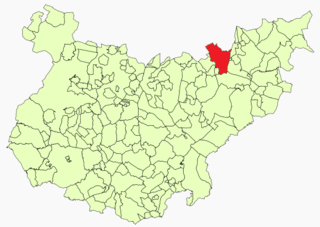
Navalvillar de Pela is a Spanish municipality in the province of Badajoz, Extremadura. It has a population of 4,816 (2007) and an area of 251.2 km².
Warren Ridge is a SW-NE ridge 2 nautical miles (3.7 km) long on the north slope of Kyle Hills, Ross Island. The ridge rises to c.1100 m at the southwest end and culminates in Dibble Peak, 1 nautical mile (1.9 km) north of Ainley Peak. Named by Advisory Committee on Antarctic Names (US-ACAN) (2000) after Stephen G. Warren, Department of Atmospheric Sciences, University of Washington, Seattle, who worked several summer seasons with United States Antarctic Program (USAP) and ANARE from 1985; investigated climate processes on the Antarctic plateau in four deployments to South Pole Station, including the full year of 1992 as station science leader.
San Miguel Suchixtepec is a town and municipality in Oaxaca in south-western Mexico. The municipality covers an area of 107.17 km². It is part of the Miahuatlán District in the south of the Sierra Sur Region.
Chucamarca is a small town in Bolivia. In 2009 it had an estimated population of 991.
Kingli is a village in Saaremaa Parish, Saare County in western Estonia.
Cox Reef is a group of drying rocks lying northwest of Box Reef off the south end of Adelaide Island. It was named by the UK Antarctic Place-Names Committee in 1963 for Able Seaman Edward F. Cox, a member of the Royal Navy Hydrographic Survey Unit which first charted this feature in 1963.

McManus Glacier is a glacier flowing north into Palestrina Glacier, in northwestern Alexander Island, Antarctica. It separates Lassus Mountains on the west from Sofia University Mountains on the east. The glacier was surveyed by the British Antarctic Survey (BAS), 1975–76, and was named by the UK Antarctic Place-Names Committee in 1980 after Alan James McManus, a BAS cook at Grytviken and Faraday Research Station, 1971–73, and at Adelaide Island and Rothera Research Station, 1975–78.
Mount Martine is a massive mountain, about 800 metres (2,600 ft) high, with a prominent rocky north face and ice-covered south slopes, overlooking the north shore of Charcot Island, south of Cheesman Island, in the east Bellinghausen Sea of Antarctica.
Mackellar Inlet is an inlet forming the northwestern head of Admiralty Bay, at King George Island in the South Shetland Islands. It was probably named by the Fourth French Antarctic Expedition under Jean-Baptiste Charcot, who charted Admiralty Bay in December 1909. Wegger Peak stands on the west side of the inlet entrance.
Last Hill is a small hill, 350 metres (1,150 ft) high, with a rock ridge at its crest and a cliff at its north side, standing 4 nautical miles (7 km) south-southwest of Hope Bay and 2 nautical miles (4 km) east of the northeast shore of Duse Bay on Tabarin Peninsula, Antarctica. It was probably seen by the Swedish Antarctic Expedition, 1901–04, under Otto Nordenskjöld, but was first charted in 1946 by the Falkland Islands Dependencies Survey, who so named it because it marks the last climb on the sledge route between Hope Bay and Duse Bay.
Asafiev Glacier is a glacier that flows north-west into Schubert Inlet from the western side of the Walton Mountains, Alexander Island, Antarctica. It was named by the USSR Academy of Sciences in 1987 after Boris Asafiev, the Russian composer.