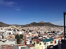
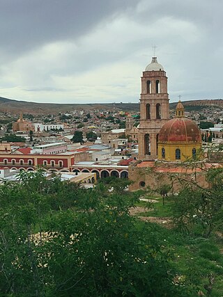
Bufa Hill or El Cerro de la Bufa is a hill found east of historic downtown area of the Mexican city of Zacatecas and is of historic and cultural significance in the state of Zacatecas. [1] [2]
Bufa Hill or El Cerro de la Bufa is a hill found east of historic downtown area of the Mexican city of Zacatecas and is of historic and cultural significance in the state of Zacatecas. [1] [2]
The origin of Bufa Hill's name is disputed. What is, perhaps, the best-known version of the tale says that the hill was christened Bufa by Juan de Tolosa. Bufa is a word that originated from Aragonese, meaning pig bladder, which was used to describe the unique shape of the hill. [3] [1]
Bufa Hill, which lies to the east of historic downtown Zacatecas, is 2,610 meters above sea level. The mountain served as a home to several Aridoamerican tribes, from whence the city Zacatecas received its name. The Chichimecan tribes that inhabited the Zacatecan area were the Caxcanes, Guachichiles, Guamares Irritilas, Huicholes, Tecuexes, Teules, Tepehuanes, Coras, y Zacatecas. The Zacatecas tribe was considered to be one of the most important. Thus, not only did the city of Zacatecas inherit the tribal name, but so did the state. [4] The Caxcanes occupied a large portion of what now comprises the states of Jalisco and Zacatecas. The Bufa is a tourist attraction that marks the victory of the Battle of Zacatecas, a significant moment in the history of the state.
The four founding fathers of Zacatecas, a mining city, were Juan de Tolosa, Cristóbal de Oñate, Diego de Ibarra, and Baltazar Temiño de Bañuelos. [5]
When the Spanish, who were searching for precious metals, arrived at what is now Zacatecas, they entered through a mountainous path that led to a valley. Soon, they came across a large mountain which Juan de Tolosa named Bufa Hill.
In the year 1588, Bufa Hill had gained so much importance that it was included in the city's arms, with the support of Felipe II.
Bufa Hill was also important in the arrival of Miguel Hidalgo y Costilla and in the Mexican War of Independence.
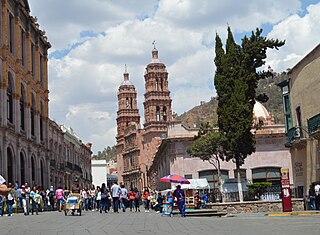
Zacatecas is the principal city within the municipality in Mexico of the same name, and the capital and the largest city of the state of Zacatecas. Located in north-central Mexico, the city had its start as a Spanish mining camp in the mid-16th century. Native Americans had already known about the area's rich deposits of silver and other minerals. Due to the wealth that the mines provided, Zacatecas quickly became one of the most important mining cities in New Spain. The area saw battles during the turbulent 19th century, but the next major event was the Battle of Zacatecas during the Mexican Revolution when Francisco Villa captured the town, an event still celebrated every anniversary. Today, the colonial part of the city is a World Heritage Site, due to the Baroque and other structures built during its mining days. Mining still remains an important industry. The name Zacatecas is derived from the Zacateco people and has its roots in Nahuatl. The name means "people of the grasslands".

Guanajuato is a municipality in central Mexico and the capital of the state of the same name. It is part of the macroregion of the Bajío. It is located in a narrow valley, which makes its streets narrow and winding. Most are alleys that cars cannot pass through, and some are long sets of stairs up the mountainsides. Many of the city's thoroughfares are partially or fully underground. The historic center has numerous small plazas and colonial-era mansions, churches, and civil constructions built using pink or green sandstone. The city historic center and the adjacent mines were proclaimed a World Heritage Site by UNESCO in 1988.

San Luis Potosí, commonly called SLP or simply San Luis, is the capital and the most populous city of the Mexican state of San Luis Potosí. It is the municipal seat of the surrounding municipality of San Luis Potosí. The city lies at an elevation of 1,864 metres. It has an estimated population of 824,229 in the city proper and a population of approximately 1,221,526 in its metropolitan area, formed with the neighbour city of Soledad de Graciano Sánchez and other surrounding municipalities, which makes the metropolitan area of Greater San Luis Potosí the eleventh largest in Mexico.

Durango, officially named Estado Libre y Soberano de Durango, is one of the 31 states which make up the 32 Federal Entities of Mexico, situated in the northwest of the country. With a population of 1,832,650, the 8th lowest of Mexico's states, Durango has Mexico's second-lowest population density, after Baja California Sur. The capital city, Victoria de Durango, is named after the first President of Mexico, Guadalupe Victoria.
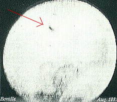
The Bonilla observation was an astronomical event in 1883 in which hundreds of unidentified flying objects were observed and photographed by Mexican astronomer José Bonilla.

Villa Guerrero is a municipality in the north of the state of Jalisco, México. It is located between 103°22′30″ and 103°50′00″ longitude west and 21°54′00″ and 22°10′00″ latitude north, at an altitude of 1,767 metres (5,797 ft) above sea level. The municipality covers an area of 673.3 square kilometres (260.0 sq mi).

The Zacatecos is the name of an indigenous group, one of the peoples called Chichimecas by the Aztecs. They lived in most of what is now the state of Zacatecas and the northeastern part of Durango. They have many direct descendants, but most of their culture and traditions have disappeared with time. Large concentrations of modern-day descendants may reside in Zacatecas and Durango, as well as other large cities of Mexico.

Ojitos de Santa Lucía is a town located in the northwestern region of the Mexican state of Zacatecas. According to the 2000 census it had a population of 1,800 inhabitants.

The Mixtón War (1540-1542) was a rebellion by the Caxcan people of northwestern Mexico against the Spanish conquerors. The war was named after Mixtón, a hill in Zacatecas which served as an Indigenous stronghold.

Ojuelos de Jalisco is a colonial town and municipality in the state of Jalisco, Mexico. The town's 1990 population was 7,265, although by the year 2010 it had increased to 11,881.
The Bajío is a cultural and geographical region within the central Mexican plateau which roughly spans from northwest of Mexico City to the main silver mines in the northern-central part of the country. This includes the states of Querétaro, Guanajuato, parts of Jalisco, Aguascalientes and parts of Zacatecas, San Luis Potosí and Michoacán.

The Camino Real de Tierra Adentro, also known as the Silver Route, was a Spanish 2,560-kilometre-long (1,590 mi) road between Mexico City and San Juan Pueblo, New Mexico, that was used from 1598 to 1882. It was the northernmost of the four major "royal roads" that linked Mexico City to its major tributaries during and after the Spanish colonial era.
Sombrerete is a town and municipality located in the northwest of the Mexican state of Zacatecas, bordering the state of Durango.

Cerro de San Pedro is a village and seat of the municipality of Cerro de San Pedro, located in the Mexican state of San Luis Potosí in central Mexico. It is located in hills, 5 kilometres (3.1 mi) northeast of the city of San Luis Potosí.
Teúl de González Ortega Municipality is a town and municipality located in the south of the Mexican state of Zacatecas, between the state capital of Zacatecas and the city of Guadalajara. Unlike most of the rest of the state, its economy has been based on agriculture and livestock, rather than mining, and it is noted for its production of agave and mezcal. The town has been named a Pueblo Mágico to promote a tourism industry.

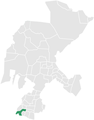
Zacatecas ( ), officially the Free and Sovereign State of Zacatecas, is one of the 31 states of Mexico. It is divided into 58 municipalities and its capital city is Zacatecas.

Francisco Tenamaztle, also Tenamaxtlan, Tenamaxtli or Tenamaxtle, was a leader of the Caxcan indigenous peoples in Mexico during the Mixtón War of 1540–1542. He was later put on trial in Spain. With the support of Bartolomé de las Casas he defended the justice of his cause by appealing to King Carlos I.
Juan de Tolosa was a Spanish Basque conquistador. He discovered rich silver deposits near the present day city of Zacatecas, Mexico, in 1546.

El Teúl is an important archaeological Mesoamerican site located on a hill with the same name in the municipality of Teúl in the south of the Mexican state of Zacatecas, near the border with the state of Jalisco.

Juchipila is a municipality in the Mexican state of Zacatecas, located approximately 160 kilometres (99 mi) southwest of the state capital Zacatecas City.