
Mississippi County is the easternmost county in the U.S. state of Arkansas. As of the 2020 census, the population was 40,685. There are two county seats, Blytheville and Osceola. The county is named for the Mississippi River which borders the county to the east. Mississippi County is part of the First Congressional District in Arkansas.

Craighead County is a county located in the U.S. state of Arkansas. As of the 2020 census, the population was 111,231. The county has two county seats — Jonesboro and Lake City. Craighead County is Arkansas's 58th county, formed on February 19, 1859, and named for state Senator Thomas Craighead. It is one of several dry counties within the state of Arkansas, in which the sale of alcoholic beverages is largely prohibited.

Black Oak is a town in Craighead County, Arkansas, United States. The population was 262 at the 2010 census. It is included in the Jonesboro, Arkansas Metropolitan Statistical Area. Black Oak is the namesake of 1970s rock band Black Oak Arkansas and the setting of John Grisham's novel A Painted House.

Jonesboro is a city located on Crowley's Ridge in the northeastern corner of the U.S. State of Arkansas. Jonesboro is one of two county seats of Craighead County. In 2022, the city had an estimated population of 79,876, making it the fifth-most populous city in Arkansas. In 2020, the Jonesboro metropolitan area had a population of 134,196, and the Jonesboro-Paragould Combined Statistical Area had a population of 179,932.

Monette is a city in Craighead County, Arkansas, United States. The city is located in an area of Northeast Arkansas known as Buffalo Island. The population was 1,506 at the 2020 census.

Leachville is a city in Mississippi County, Arkansas, United States. The population was 2,039 at the 2020 census. Leachville was incorporated in 1916.

Crowley's Ridge is a geological formation that rises 250 to 550 feet (170 m) above the alluvial plain of the Mississippi embayment in a 150-mile (240 km) line from southeastern Missouri to the Mississippi River near Helena, Arkansas. It is the most prominent feature in the Mississippi Alluvial Plain between Cape Girardeau, Missouri, and the Gulf of Mexico.
The Ozark – St. Francis National Forest is a United States National Forest that is located in the state of Arkansas. It is composed of two separate forests, Ozark National Forest in the Ozark Mountains; and St. Francis National Forest on Crowley's Ridge. Each forest has distinct biological, topographical, and geological differences.

The Jonesboro Metropolitan Statistical Area, as defined by the United States Census Bureau, is an area consisting of two counties – Craighead and Poinsett – in northeast Arkansas, anchored by the city of Jonesboro. As of the 2010 census, the MSA had a population of 121,026. It is also part of the larger Jonesboro-Paragould Combined Statistical Area.

Highway 77 is a north–south state highway in Northeast Arkansas. The route of 66.70 miles (107.34 km) runs from US Highway 70 (US 70) in West Memphis north through small towns and agricultural areas of the Arkansas Delta to the Missouri state line. It is generally a low-traffic road except in West Memphis. Created during the 1926 Arkansas state highway numbering, the route was extended in the 1950s and 1960s, including along a former alignment of US 61. AR 77 does not have any spur or business routes.

The Jonesboro–Paragould Combined Statistical Area is made up of three counties in northeastern Arkansas. The CSA consists of the Jonesboro Metropolitan Statistical Area and the Paragould Micropolitan Statistical Area. As of the 2010 census, the CSA had a population of 163,116.

The geography of Arkansas varies widely. The state is covered by mountains, river valleys, forests, lakes, and bayous in addition to the cities of Arkansas. Hot Springs National Park features bubbling springs of hot water, formerly sought across the country for their healing properties. Crowley's Ridge is a geological anomaly rising above the surrounding lowlands of the Mississippi embayment.

Highway 18 is an east–west state highway of 93.43 miles (150.36 km) in Northeast Arkansas. It has concurrency with U.S. Route 78 (US 78) much of its length.

Highway 148 is a designation for three east–west state highways in the Upper Arkansas Delta. One route of 4.61 miles (7.42 km) begins at Highway 239 and runs east to a Mississippi River levee. A second route of 8.81 miles (14.18 km) begins at Highway 181 and runs east to US Highway 61 in Burdette. A third route of 3.53 miles (5.68 km) begins at Highway 135 in Black Oak and runs east to Highway 139. All routes are maintained by the Arkansas State Highway and Transportation Department (AHTD).

Arkansas Highway 158 is a designation for two state highways in northeast Arkansas. The main segment of 44.24 miles (71.20 km) runs east from Highway 1 to US Route 61 (US 61) in Luxora. A short route of 0.33 miles (0.53 km) runs from U.S. Route 49 across railroad tracks in rural Craighead County.
Three auxiliary routes of Arkansas Highway 18 exist in Northeast Arkansas, with one former alignment.
Buffalo Island Central School District is a public school district based in Monette, Arkansas, United States. The Buffalo Island Central School District provides early childhood, elementary and secondary education for more than 850 prekindergarten through grade 12 students at its four northeast Arkansas facilities at Monette in Craighead County and Leachville in Mississippi County.
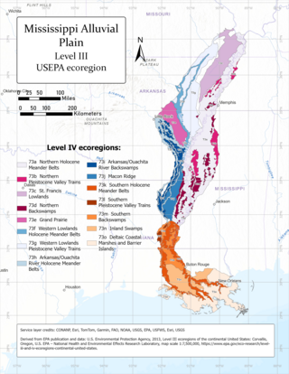
The Mississippi Alluvial Plain is a Level III ecoregion designated by the Environmental Protection Agency (EPA) in seven U.S. states, though predominantly in Arkansas, Louisiana, and Mississippi. It parallels the Mississippi River from the Midwestern United States to the Gulf of Mexico.
Twin Rivers School District was a school district in Lawrence, Randolph, and Sharp counties in Arkansas. It was headquartered in the Oak Ridge Central Campus in unincorporated Randolph County, near Ravenden Springs. It served various communities, including Ravenden Springs.
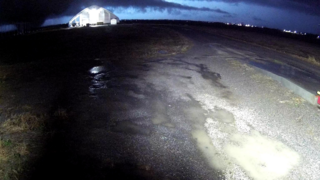
Throughout the evening hours of December 10, 2021, a large and destructive tornado struck areas in and around the cities and communities of Monette (AR), Leachville (AR), Braggadocio (MO), Hayti (MO), Tiptonville (TN) and Samburg (TN), killing eight people and injuring 16 others. The tornado was the second strongest and third deadliest of the tornado outbreak of December 10–11, 2021. The tornado reached peak intensity twice, the first time east of Braggadocio, Missouri and the second time in Tiptonville, Tennessee, leading the National Weather Service to assign a rating of low-end EF4 on the Enhanced Fujita scale, with maximum wind speeds estimated at 170 mph (270 km/h).