
Benguela is a province of Angola, situated in the west of the country. It lies on the Atlantic Ocean, and borders the provinces of Cuanza Sul, Namibe, Huila, and Huambo. The province has an area of 39,826 square kilometres (15,377 sq mi) and its capital is Benguela. According to the 2014 census, there were 2,231,385 inhabitants in the province. The current governor of Benguela is Isaac dos Anjos.

Lobito is a municipality in Angola. It is located in Benguela Province, on the Atlantic Coast north of the Catumbela Estuary. The Lobito municipality had a population of 393,079 in 2014.
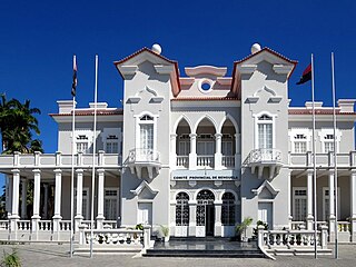
Benguela is a city in western Angola, capital of Benguela Province. Benguela is one of Angola's most populous cities with a population of 555,124 in the city and 561,775 in the municipality, at the 2014 census.

The Nyungwe Forest is located in southwestern Rwanda, on the border with Burundi, where it is contiguous with the Kibira National Park to the south, and Lake Kivu and the Democratic Republic of the Congo to the west. The Nyungwe rainforest is probably the best preserved montane rainforest in Central Africa. It is located in the watershed between the basin of the river Congo to the west and the basin of the river Nile to the east. From the east side of the Nyungwe forest comes also one of the branches of the Nile sources.
Iona National Park is the largest national park in Angola. It is situated in the Southwestern corner of the country, in Namibe Province. It is roughly bound by the Atlantic Ocean to the West, an escarpment to the East that marks the beginning of the interior plateau, the Curoca River to the North, and the Cunene River to the South. It is about 200 kilometres (120 mi) south of the city of Namibe and covers 5,850 square miles (15,200 km2) sq. miles.
Bicuari National Park is a national park in Angola. It is located in the south-west region of the country on the Huila Plateau, about 120 km SE of Lubango. The park is an area of sandy hills and shrub thicket character. The climate is tropical semi-arid. Bicuar was established as a hunting reserve in 1938, and reformed as a national park in 1964. Historically known for its large mammals, such as the black buffalo, the park suffered heavily in the Angolan Civil War (1975-2002). During this time the animals were mostly or entirely exterminated, but the Angolan Government is now undertaking efforts to rebuild the infrastructure and resettle the animals.
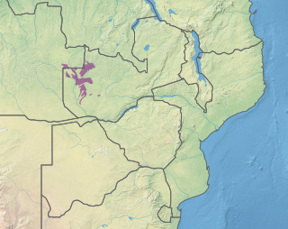
Luengue-Luiana National Park is a national park in Angola.

Angola is located on the western Atlantic Coast of Southern Africa between Namibia and the Republic of the Congo. It also is bordered by the Democratic Republic of the Congo and Zambia to the east. The country consists of a sparsely watered and somewhat sterile coastal plain extending inland for a distance varying from 50 to 160 km. Slightly inland and parallel to the coast is a belt of hills and mountains and behind those a large plateau. The total land size is 1,246,700 km2 (481,400 sq mi). It has an Exclusive Economic Zone of 518,433 km2 (200,168 sq mi).
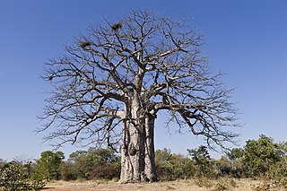
Angolan miombo woodlands cover most of central Angola and extend into the Democratic Republic of Congo. They are part of the larger miombo ecosystem that covers much of eastern and southern Africa.
The Central Zambezian miombo woodlands ecoregion spans southern central Africa. Miombo woodland is the predominant plant community. It is one of the largest ecoregions on the continent, and home to a great variety of wildlife, including many large mammals.

Kalahari Acacia-Baikiaea woodlands is an ecoregion located in Botswana, northern Namibia, South Africa and Zimbabwe.
The Zambezian dry evergreen forest, also known as the Zambezian Cryptosepalum dry forest, is a tropical dry broadleaf forest ecoregion of Southern Africa. It consists of several areas of thick forest in western Zambia and adjacent Angola. It is one of the largest areas of tropical evergreen forest outside the equatorial zone.
Namibe Partial Reserve is a protected area in Angola. It is located to the north of Iona National Park, and separated by a narrow strip of occupied land along the Curoca River. This reserve has IUCN Category IV status and was proclaimed in 1960 by the authorities of Portuguese Angola. It covers 4,450 square kilometres (1,720 sq mi). This park is planned to be included into the Iona - Skeleton Coast Transfrontier Conservation Area.

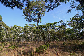
The Angolan Scarp savanna and woodlands is an ecoregion located on the coast of Angola, an area with a variety of habitats and rich in wildlife including many endemic birds and animals.
The Kidepo Game Reserve is a protected area located in Budi County, Eastern Equatoria State, South Sudan, Africa. With an area of 1200 km2, this reserve is located 4° 04'N and 33° 28'E on the South Sudan/Uganda border, where it forms a contiguous ecosystem with Uganda's Kidepo Valley National Park.

Bwabwata National Park is a protected area in northeastern Namibia that was established in 2007 and covers 6,274 km2 (2,422 sq mi). It was created by merging Caprivi Game Park and Mahango Game Reserve. It is situated in the Zambezi and Kavango East regions, extending along the Caprivi Strip. It is bounded by the Okavango River to the west and the Kwando River to the east. Angola lies to the north and Botswana to the south.

The Western Zambezian grasslands is a tropical grassland ecoregion of eastern Zambia and adjacent parts of Angola. It is situated in two sections, to the north and south of the Barotse Floodplain. The region supports herds of ungulates, including Zambia's largest herd of Blue Wildebeast.

The southern Congolian forest–savanna mosaic is an ecoregion that covers a large area of the southern Democratic Republic of the Congo and northeastern Angola. Its rich blend of habitats provides key insights into the biogeography of central Africa with the extensive climatic variation that it has been experiencing for the last 10 million years. The human population is not high.

The Western Congolian forest–savanna mosaic is an ecoregion of Angola, Democratic Republic of the Congo, Republic of the Congo, and Gabon.
