Baneheide is a town in the Dutch province of Limburg. It is a part of the municipality of Simpelveld, and lies about 9 km southwest of Kerkrade.

Bocholtz is a town in the Dutch province of Limburg. It is a part of the municipality of Simpelveld, and lies about 7 km southwest of Kerkrade. Until 1982, it was a separate municipality.
Parkstad Limburg is a conurbation of eight municipalities in the southern part of the province of Limburg in the Netherlands. Consisting Heerlen, Kerkrade, Landgraaf, Brunssum, Simpelveld, Voerendaal, Nuth and Onderbanken, the municipalities work together to improve public services, transport and housing on a regional level. This collaboration started in 1999. Within Parkstad, the city of Heerlen functions as the centre of economic and social activity, and to a lesser extent the cities Kerkrade and Landgraaf function in the same regard as regional hubs.

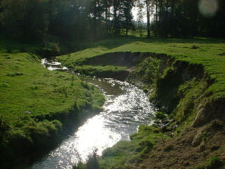
The Zuid-Limburgse Stoomtrein Maatschappij or ZLSM is a heritage railway operating from its main station of Simpelveld to Schin op Geul and Kerkrade in the south of the Netherlands. It also runs over the border from Simpelveld to Vetschau in Germany and has an extensive collection of stock. The ZLSM is currently partnered with the Great Central Railway in England, as they are both double-track preserved lines.

Czumów is a village in the administrative district of Gmina Hrubieszów, within Hrubieszów County, Lublin Voivodeship, in eastern Poland, close to the border with Ukraine. It lies approximately 8 kilometres (5 mi) south-east of Hrubieszów and 112 km (70 mi) south-east of the regional capital Lublin.
Gródek is a village in the administrative district of Gmina Hrubieszów, within Hrubieszów County, Lublin Voivodeship, in eastern Poland, close to the border with Ukraine. It lies approximately 5 kilometres (3 mi) east of Hrubieszów and 109 km (68 mi) south-east of the regional capital Lublin. Important archeological site.
Husynne is a village in the administrative district of Gmina Hrubieszów, within Hrubieszów County, Lublin Voivodeship, in eastern Poland, close to the border with Ukraine. It lies approximately 8 kilometres (5 mi) east of Hrubieszów and 109 km (68 mi) south-east of the regional capital Lublin.
Nowosiółki is a village in the administrative district of Gmina Hrubieszów, within Hrubieszów County, Lublin Voivodeship, in eastern Poland, close to the border with Ukraine. It lies approximately 5 kilometres (3 mi) north-west of Hrubieszów and 100 km (62 mi) south-east of the regional capital Lublin.
Turkołówka is a village in the administrative district of Gmina Hrubieszów, within Hrubieszów County, Lublin Voivodeship, in eastern Poland, close to the border with Ukraine. It lies approximately 8 kilometres (5 mi) north of Hrubieszów and 101 km (63 mi) south-east of the regional capital Lublin.
Korczmin is a village in the administrative district of Gmina Ulhówek, within Tomaszów Lubelski County, Lublin Voivodeship, in eastern Poland, close to the border with Ukraine. It lies approximately 8 kilometres (5 mi) south-east of Ulhówek, 33 km (21 mi) east of Tomaszów Lubelski, and 131 km (81 mi) south-east of the regional capital Lublin.
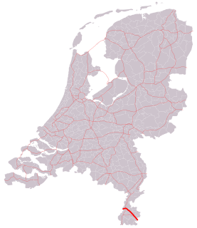
The A76 motorway is a motorway in the Netherlands. It is located entirely in the Dutch province of Limburg.
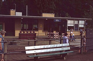
Kerkrade Centrum is a railway station in Kerkrade, the Netherlands. The station was built in 1933 on the Schaesberg–Simpelveld railway and is the eastern terminus of the Heuvellandlijn (Maastricht–Kerkrade). However, as the Dutch Railways deemed it unprofitable at the time, the station did not see passenger services until 15 May 1949, when regular passenger services finally commenced on the Schaesberg–Simpelveld railway. Train services were operated by Veolia until 11 December 2016, when Arriva took over.
Króle is a village in the administrative district of Gmina Bartoszyce, within Bartoszyce County, Warmian-Masurian Voivodeship, in northern Poland, close to the border with the Kaliningrad Oblast of Russia. It lies approximately 14 kilometres (9 mi) south-east of Bartoszyce and 50 km (31 mi) north-east of the regional capital Olsztyn.

Molsberg is a hamlet in the southeastern Netherlands. It is located close to the village of Simpelveld in the municipality of Simpelveld, Limburg, about 20 km east of Maastricht. The village has a population of 300 people after it was expanded with 54 new houses in 2004.

Imstenrade is a hamlet in the southeastern Netherlands. It is part of the municipality of Heerlen in the province of Limburg, about 20 km east of Maastricht. The village lies between Benzenrade and Simpelveld, next to the A76 motorway and the N281 provincial road. In 2014 the village had a population of 336 and was home to an immigration detention centre with space for 700 immigrants.

Bosschenhuizen is a hamlet in the southeastern Netherlands. It is part of the municipality of Simpelveld in the province of Limburg, about 20 km east of Maastricht. The village lies southeast of Trintelen and west of Simpelveld. In 2016 the village had an estimated population of 80.

Huls is a hamlet in the southeastern Netherlands. It is part of the municipality of Simpelveld in the province of Limburg, about 20 km east of Maastricht. The village lies on a hill, north of Simpelveld, and south of Ubachsberg. In 2008 the village had a population of 350 on an area of 0.44 km2. On the hillside south of Huls lies Hulsveld, a hamlet sharing the same name with a population of 1630. Since the hamlets share a single built-up area, and are both located on the hill called Huls, the village Huls is sometimes mistaken to include Hulsveld.