A cave or cavern is a natural void in the ground, specifically a space large enough for a human to enter. Caves often form by the weathering of rock and often extend deep underground. The word cave can also refer to much smaller openings such as sea caves, rock shelters, and grottos, though strictly speaking a cave is exogene, meaning it is deeper than its opening is wide, and a rock shelter is endogene.

Mammoth Cave National Park is an American national park in central Kentucky, encompassing portions of Mammoth Cave, the longest cave system known in the world. Since the 1972 unification of Mammoth Cave with the even-longer system under Flint Ridge to the north, the official name of the system has been the Mammoth–Flint Ridge Cave System. The park was established as a national park on July 1, 1941, a World Heritage Site on October 27, 1981, and an international Biosphere Reserve on September 26, 1990.

Yellville is a city and county seat in Marion County, Arkansas, United States. Yellville is located in the Ozark Mountains along the banks of Crooked Creek, and neighbors the small town of Summit to the north. The population was 1,204 at the 2010 Census. The town's original name is preserved in the Shawnee Town Branch, a local creek. The town also holds an annual Turkey Trot Festival.
Crystal Cavern(s), also known throughout the years as Alabama Caverns and McClu(n)ney Cave, is a small cavern containing crystal formations located in Clay, Alabama, USA.

Kartchner Caverns State Park is a state park of Arizona, United States, featuring a show cave with 2.4 miles (3.9 km) of passages. The park is located 9 miles (14 km) south of the town of Benson and west of the north-flowing San Pedro River. Long hidden from view, the caverns were discovered in 1974 by local cavers, assisted by a state biologist who helped in its preservation.

The Russell Cave National Monument is a U.S. National Monument in northeastern Alabama, United States, close to the town of Bridgeport. The Monument was established on May 11, 1961, when 310 acres (1.3 km2) of land were donated by the National Geographic Society to the American people. It is now administered and maintained by the National Park Service. The National Monument was listed on the National Register of Historic Places on October 15, 1966.

Wind Cave National Park is an American national park located 10 miles (16 km) north of the town of Hot Springs in western South Dakota. Established in 1903 by President Theodore Roosevelt, it was the seventh national park and the first cave to be designated a national park anywhere in the world. The cave is notable for its calcite formations known as boxwork, as well as its frostwork. Approximately 95 percent of the world's discovered boxwork formations are found in Wind Cave. The cave is recognized as the densest cave system in the world, with the greatest passage volume per cubic mile. Wind Cave is one of the longest caves in the world with 149.01 miles (239.81 km) of explored cave passageways, as of 2018. Above ground, the park includes the largest remaining natural mixed-grass prairie in the United States.
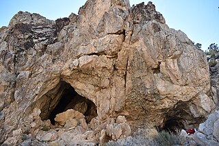
Mitchell Caverns, within the Mitchell Caverns Natural Preserve, is a trio of solutional limestone caves, located on the east side of the Providence Mountains at an elevation of 4,300 feet (1,300 m), within the Providence Mountains State Recreation Area. It is located in the Mojave Desert, in San Bernardino County, California.

Treak Cliff Cavern is a show cave near Castleton in Derbyshire, England. It is part of the Castleton Site of Special Scientific Interest and one of only two sites where the ornamental mineral Blue John is still excavated. As part of an agreement with English Nature, the Blue John that can be seen in the show cave is not mined but it is extracted in small quantities from other areas of the cave and made into saleable items like bowls, jewellery and ornaments.

Marengo Cave is a privately owned cave located in Marengo, Indiana. One of only four show caves in Indiana, public tours of the cave have been given since 1883. Tours commenced just days after the cave's discovery by two school children. The cave was designated as a National Natural Landmark in 1984.

Smoke Hole Caverns (SHC) is a picturesque show cave in Grant County in West Virginia's Eastern Panhandle.

The Jeita Grotto is a system of two separate, but interconnected, karstic limestone caves spanning an overall length of nearly 9 kilometres (5.6 mi). The caves are situated in the Nahr al-Kalb valley within the locality of Jeita, 18 kilometres (11 mi) north of the Lebanese capital Beirut. Though inhabited in prehistoric times, the lower cave was not rediscovered until 1836 by Reverend William Thomson; it can only be visited by boat since it channels an underground river that provides fresh drinking water to more than a million Lebanese.
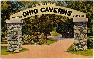
Ohio Caverns is a show cave located 30 miles (48 km) from Dayton, Ohio near West Liberty, in Salem Township, Champaign County, Ohio in the United States. A popular tourist destination and member of the National Caving Association, it is the largest of all the cave systems in Ohio and contains many crystal formations. Approximately 90% of its stalactite and stalagmite formations are still active. The cavern system was originally an aquifer, holding an underground river of melted glacier water. This river eventually receded to lower levels of the ground and is now unseen.

DeSoto Caverns is a series of caves and a tourist attraction located in Childersburg, Talladega County, Alabama. Located in the foothills of the Appalachian Mountains, it is touted as "Alabama's Big Cave". In addition to the caves, the park offers various other attractions, including a three-quarter acre maze known as the Lost Trail Maze, panning for gemstones, a climbing wall, and amusement park style rides. While on the caverns tour, visitors can view a sound, light, and water show that changes with the holidays and seasons.

Moaning Caverns is a solutional cave located in the Calaveras County, California, near Vallecito, California in the heart of the state's Gold Country. It is developed in marble of the Calaveras Formation. It was discovered in modern times by gold miners in 1851, but it has long been known as an interesting geological feature by prehistoric peoples. It gets its name from the moaning sound that echoed out of the cave luring people to the entrance, however expansion of the opening to allow access for the public disrupted the sounds. The portion of the cave developed for tourists consists of a spacious vertical shaft 165 feet tall, which is descended by a combination of stairs and a unique 100-foot-high (30 m) spiral staircase built in the early 1900s. It is open to the public for walking tours and spelunking. Including the off-trail areas, the cave reaches a depth of 410 feet.
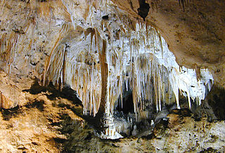
Carlsbad Caverns National Park is an American national park in the Guadalupe Mountains of southeastern New Mexico. The primary attraction of the park is the show cave, Carlsbad Cavern. Visitors to the cave can hike in on their own via the natural entrance or take an elevator from the visitor center.
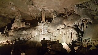
Raccoon Mountain Caverns is a commercial solution cave located in Chattanooga, Tennessee in a band of Mississippian Period limestone, part of the Cumberland Plateau.

The Madison Limestone is a thick sequence of mostly carbonate rocks of Mississippian age in the Rocky Mountain and Great Plains areas of western United States. The rocks serve as an important aquifer as well as an oil reservoir in places. The Madison and its equivalent strata extend from the Black Hills of western South Dakota to western Montana and eastern Idaho, and from the Canada–United States border to western Colorado and the Grand Canyon of Arizona.

Smoke Hole Canyon — traditionally called The Smoke Holes and later simply Smoke Hole — is a rugged 20 miles (32 km) long gorge carved by the South Branch Potomac River in the Allegheny Mountains of eastern West Virginia, United States. The area is rather isolated and remote with parts accessible only by boat or on foot.
Gap Cave is located just underneath Pinnacle Overlook in the Cumberland Gap National Historical Park, Lee County, Virginia. Currently, the cave has a surveyed length of 18.5 miles and is the 42nd longest cave in the United States and 154th in the world. There are six known entrances: the Gap Cave Entrance, an artificial entrance, known as the Cudjo's Cave Entrance, the Stream Entrance, the Soldiers Cave Entrance, the Big Saltpeter Cave Entrance, and the Wellhole. All lead into the same cave, Gap Cave.


