Related Research Articles
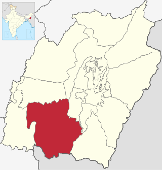
Churachandpur District, is one of the 16 districts of the Indian state of Manipur populated mainly by Kuki-Zo people. The name honours former Maharaja Sir Churachand Singh of Manipur. The district headquarters is located in the Churachandpur town, which is also locally known by the name Lamka.

Kendrapara District is an administrative district of Odisha state in eastern India. The town of Kendrapara is the district headquarters. Kendrapara District is situated in the eastern portion of the state, and is bounded on the north by Bhadrak district, on the east by the Bay of Bengal, on the south by Jagatsinghpur District, on the west by Cuttack District and on the northwest by Jajpur District.

Kadipur is a town, tehsil and a nagar panchayat in Sultanpur district in the Indian state of Uttar Pradesh. It is located a short distance from the bank of the Gomti River, at a crossroads between two roads heading from Sultanpur to Surapur and from Pratapgarh to Dostpur and then on to Akbarpur. On the north side of town is a stream with a steep ravine that drains the surrounding area. The road to Sultanpur crosses over this stream on a bridge. The lands surrounding Kadipur are average quality for agricultural purposes. As of 2011, Kadipur has a population of 8,010 people, in 1,216 households.
Mayang Imphal is a town and municipal council in Imphal West district in the Indian state of Manipur. Pin code of Mayang Imphal is 795132.
Warwat Bakal is a Gram Panchayat, in Sangrampur tehsil of Buldhana district, includes in Vidarbha region in the state of Maharashtra, India.
Churachandpur, locally known as Lamka is the second largest town in the Indian state of Manipur and the district headquarters of the Churachandpur District. The name "Churachandpur" was transferred from the earlier headquarters of the district at Songpi to the present location, and honours Churachand Singh, former maharaja of the Manipur princely state. The local people reject the name as a colonial imposition and prefer using the native name "Lamka".
Saraibeeru is a village in India, located near the Kerakat in the Jaunpur district in the state of Uttar Pradesh. The village is 30 km (19 mi) from Jaunpur.
Vellangallur is a grama panchayath situated in Thrissur district in the Indian state of Kerala.
Naya Sanwara is a village in the Sirohi district of Rajasthan, India. On the southeastern border of the village, there is a large lake where the Ambamata Temple is located. The village is administered by a locally elected president, known as Pradhan or Sarpanch. This village depends on its sub-district (Tehsil) Pindwara, the nearest city, for all major economic activities.
Appanur is a village in the Kadaladi Taluk of Ramanathapuram District in Tamil Nadu, India. It is located between Mudukulathur and Sayalgudi, on the State Highway 29 (SH29).
Nanagwas is a small village located in Neemrana Tehsil of Kotputali Bheror District, Rajasthan, India.
Aremallapur is a village in the southern state of Karnataka, India. It is located in the Ranebennur taluk of Haveri district in Karnataka.
Sumchinvum is a small village in Singngat-Sub-Division, Churachandpur District, Manipur, India. It was also known as 'Dimmual' by the Tedim people inhibiting in the village before the Kuki–Paite ethnic clash of 1997–98.
Pherzawl is the headquarter of the Pherzawl District of Manipur, India. Pherzawl district was created by bifurcating Churachandpur district.
Khamlang village is situated on the southern part of Ukhrul District, Manipur, India. It is inhabited by Khameon a Tangkhul Naga tribe. It is situated 2 km away from headquarter of Sub-Division, Kasom Khullen, 137 km away from district headquarter Ukhrul and 59 km from state capital Imphal, Manipur.
Wangoo is a village in the Kakching district of the Indian state of Manipur. It is situated approximately 64 km south of the state capital, Imphal. It has an area of 13.05 km2 with a population of 6134.
Surhan is a village in Martinganj Block in Azamgarh district of Uttar Pradesh State, India. It belongs to Azamgarh Division. It is located 44 km west of the District headquarters Azamgarh. 1 km from Martinganj. 249 km from State capital Lucknow.
Rengkai is the most populated and one of the three census towns of Churachandpur District in the Indian state of Manipur.

Charpokhari is a village and corresponding community development block in Bhojpur district of Bihar, India. As of 2011, its population was 1,874, in 314 households. The total block population was 101,363, in 15,961 households.
Doma is a large village of Chimur Taluka in Chandrapur district of Maharashtra, India.
References
- 1 2 "Census of India 2011 - Manipur" (PDF). censusindia.gov.in. October 2011. Retrieved 29 November 2020.
- ↑ "Bungmual Post Office & Pin Code - 795006, Churachandpur district of Manipur : GETATOZ". www.getatoz.com. Retrieved 11 August 2020.
- ↑ "Pin Code: BUNGMUAL, CHURACHANDPUR, MANIPUR, India, Pincode.net.in". pincode.net.in. Retrieved 11 August 2020.