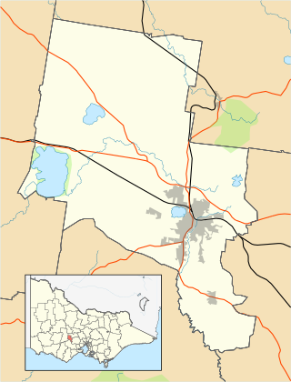
The City of Ballarat is a local government area in the west of the state of Victoria, Australia. It covers an area of 739 square kilometres (285 sq mi) and, in June 2018, had a population of 107,325. It is primarily urban with the vast majority of its population living in the Greater Ballarat urban area, while other significant settlements within the LGA include Buninyong, Waubra, Learmonth and Addington. It was formed on 6 May 1994 from the amalgamation of the City of Ballarat, Shire of Ballarat, Borough of Sebastopol and parts of the Shire of Bungaree, Shire of Buninyong, Shire of Grenville and Shire of Ripon.

Queenscliff is a small town on the Bellarine Peninsula in southern Victoria, Australia, south of Swan Bay at the entrance to Port Phillip. It is the administrative centre for the Borough of Queenscliffe. At the 2016 census, Queenscliff had a population of 1,315.

La Trobe Street is a major street and thoroughfare in the Melbourne central business district, Victoria, Australia. It runs roughly east–west and forms the northern boundary of the central business district. The street was laid out as an extension of the original Hoddle Grid in 1839 and was named after Charles La Trobe. La Trobe Street extends from Victoria Street in the east to Harbour Esplanade in the west.
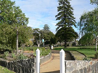
St Vincent Gardens in the Melbourne suburb of Albert Park, is an Australian park of national significance.

Buninyong is a town 11 km from Ballarat in Victoria, Australia. The town is on the Midland Highway, south of Ballarat on the road to Geelong.

Established in 1937, Epworth Freemasons, located at 166 Clarendon St in East Melbourne, was a practical expression of the work of Freemasonry in the Victorian community. It is now run by Epworth Healthcare.

Ballarat railway station is located on the Serviceton line in Victoria, Australia. It serves the city of Ballarat, and opened on 11 April 1862 as Ballarat West. It was renamed Ballarat in 1865.

Fitzroy Town Hall is a civic building located in Napier Street in Fitzroy, a suburb of Melbourne, Australia.
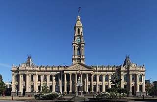
South Melbourne Town Hall is a landmark civic building located on Bank Street in South Melbourne, a suburb of Melbourne, Victoria, Australia. It is listed on the Victorian Heritage Register as of state heritage significance to Victoria.
Bung Bong is a locality in Victoria between the towns of Avoca and Maryborough. The locality is divided, with the Western section in the Pyrenees Shire and the Eastern section in Shire of Central Goldfields. The Bet Bet Creek runs towards the north through the middle of the locality and then into the Loddon River. Bung Bong is located on the Pyrenees Highway.

The City of Ballaarat was a local government area covering the inner suburbs of the regional city of Ballarat, Victoria, Australia. The city covered an area of 34.52 square kilometres (13.3 sq mi), and existed from 1855 until 1994.

The Borough of Sebastopol was a local government area about 4 kilometres (2 mi) south of the regional city of Ballarat, Victoria, Australia. The borough covered an area of 7.61 square kilometres (2.9 sq mi), and existed from 1864 until 1994.

The Shire of Ballarat was a local government area immediately to the northwest and west of the regional city of Ballarat, Victoria, Australia. The shire covered an area of 481.74 square kilometres (186.0 sq mi), and existed from 1856 until 1994.

The Shire of Bungaree was a local government area northeast of the regional city of Ballarat, Victoria, Australia. The shire covered an area of 228 square kilometres (88.0 sq mi) and existed from 1863 until 1994.

The Shire of Buninyong was a local government area south and southeast of the regional city of Ballarat, Victoria, Australia. The shire covered an area of 785.1 square kilometres (303.1 sq mi), and existed from 1858 until 1994.

The Shire of Grenville was a local government area southwest of the regional city of Ballarat, Victoria, Australia. The shire covered an area of 845 square kilometres (326.3 sq mi), and existed from 1861 until 1994.

The Shire of Leigh was a local government area about 140 kilometres (87 mi) west of Melbourne, the state capital of Victoria, Australia. The shire covered an area of 982 square kilometres (379.2 sq mi), and existed from 1861 until 1994.
The Buninyong Line was a Victorian Railways (Australia) branch line, which ran south from Ballarat to the town of Buninyong. The line branched from the main Melbourne – Ballarat railway at Ballarat East station and was 11 km long. The line was opened on 11 September 1889, with traffic commencing the following day.

Traralgon Post Office and Court House is a heritage-listed post office and former court house complex at 161-169 Franklin Street, Traralgon, Victoria, Australia. It was designed by John Thomas Kelleher and J. R. Brown of the colonial Department of Public Works and built in 1886. The entire building was added to the Victorian Heritage Register on 20 August 1982, with the federally-owned post office wing also being listed on the Australian Commonwealth Heritage List on 8 November 2011.

Scarborough Town Hall, originally St Nicholas House, is a red brick Jacobean Revival mansion in Scarborough, North Yorkshire, England, currently used as a municipal building for the Borough of Scarborough and an events venue. It was built in the 19th century as a home for John Woodall, a prominent local businessman, and then converted and extended for municipal use in 1903. Situated overlooking the South Bay, it is a grade II listed building.
