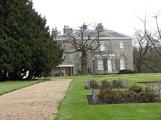
Horning is an ancient village and parish in the English county of Norfolk.
It covers an area of 11 km2 and had a population of 1,033 in the 2001 census. Horning parish lies on the northern bank of the River Bure south of the River Thurne and is located in The Broads National Park. For the purposes of local government, it falls within the district of North Norfolk, although areas alongside the rivers and broads fall into the executive area of the Broads Authority.

Wroxham Broad is an area of open water alongside the River Bure near the village of Wroxham in Norfolk, England within The Broads National Park. The Norfolk Broads were formed by the flooding of ancient peat workings. Wroxham Broad has an area of 34.4 hectares and a mean depth of 1.3 metres. It lies to the west of the Bure, with two navigable openings between river and broad. The village and broad lie in an area of fairly intensive agriculture, with areas of wet woodland adjoining the broad and river.

Hoveton is a village and civil parish in the English county of Norfolk. It is located within the Norfolk Broads, and immediately across the River Bure from the village of Wroxham. Whilst Hoveton is north of the river, Wroxham is south; but many people refer to the whole settlement as "Wroxham".

The River Bure is a river in the county of Norfolk, England, most of it in the Broads. The Bure rises near Melton Constable, 11 miles (18 km) upstream of Aylsham, which was the original head of navigation. Nowadays, the head of navigation is 10 miles (16 km) downstream at Coltishall Bridge.
After Aylsham Lock and Burgh Bridge, the Bure passes through Buxton Lammas, Coltishall, Belaugh, Wroxham, Horning, Ludham Bridge, past St. Benet's Abbey, through Oby, Acle, Stokesby, along the northern border of the Halvergate Marshes, through Runham and Great Yarmouth where it meets Breydon Water and flows into the sea at Gorleston.

The Marriott's Way is a long-distance footpath, cycle-path and bridleway between Norwich and Aylsham, Norfolk, England. It forms part of the National Cycle Network (NCN) and the red route of Norwich's Pedalways cycle path network. It is open to walkers, cyclists and horse riders. Its total length is 24.6 miles (39.5 km). It has a mixture of surfaces; tarmac, compacted gravel, and earth. The name of the route originates from the chief engineer and manager of the Midland and Great Northern Joint Railway (M&GNJR), William Marriott, who held the position for 41 years.

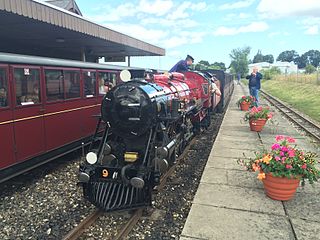
The Aylsham Bypass Tunnel is the only railway tunnel in Norfolk, England currently open to trains. It carries the narrow gauge Bure Valley Railway under the Aylsham Bypass. The former Norfolk & Suffolk Joint Railway's Cromer Tunnel at Cromer is disused.

Hoveton & Wroxham railway station is on the Bittern Line in Norfolk, England, serving the village of Hoveton and the adjacent town of Wroxham. It is 8 miles 61 chains (14.1 km) down the line from Norwich and is situated between Salhouse and Worstead.

Coltishall railway station serves the town of Coltishall in Norfolk, and is currently operated by the Bure Valley Railway.
Aylsham South railway station served the town of Aylsham in Norfolk from 1880 to 1981. The period station buildings were subsequently demolished in 1989 to allow for the construction of Aylsham railway station, the northern terminus of the Bure Valley Railway, a narrow gauge operation which reuses some of the trackbed of the old railway line.
The following are lists of recreational walks in Norfolk, England.
Little Hautbois is a small hamlet in Broadland, England, part of the parish of Lamas. The name is pronounced 'Hobbis', and can be seen thus spelled on a memorial on the outside of nearby Lamas Church. The population of the hamlet is included in the civil parish of Buxton with Lamas. In the Middle Ages, the settlement of Great Hautbois was the head of the navigation on the River Bure, and it is thought Little Hautbois developed from that. The name, which can be translated to "High Woods" in English, is taken from that of the de Alto Bosco, or de Haut Bois, family, who acquired these lands at the Norman Conquest.

This article is about the BVR heritage railway station. For the adjacent National Rail station, see Hoveton and Wroxham railway station.

Aylsham railway station is located in the town of Aylsham in Norfolk and is the northern terminus of the Bure Valley Railway, a narrow gauge operation which reuses some of the trackbed of a former standard gauge branch line, closed in 1977. The station occupies the same site as the former Aylsham South railway station, which operated here between 1880 and 1952.
The East Norfolk Railway was a standard gauge 25 mile, mostly single track, railway running between Norwich Thorpe railway station and Cromer in the English county of Norfolk. It opened in 1874, reaching Cromer three years later, and remains mostly operational. The line also operated a branch between Wroxham and County School, which closed to passengers in 1952.
Her Majesty's Prison Bure, more commonly known as HM Prison Bure, and often abbreviated to HMP Bure, is a Category C men's prison, located in the parish of Scottow in Norfolk, England. The prison is operated by Her Majesty's Prison Service, and became operational in November 2009.

The Mermaid (river) is a minor tributary of the River Bure in Norfolk, England, and is approximately 6 kilometres (3.7 mi) in length.


