
Transhumance is a type of pastoralism or nomadism, a seasonal movement of livestock between fixed summer and winter pastures. In montane regions, it implies movement between higher pastures in summer and lower valleys in winter. Herders have a permanent home, typically in valleys. Generally only the herds travel, with a certain number of people necessary to tend them, while the main population stays at the base. In contrast, horizontal transhumance is more susceptible to being disrupted by climatic, economic, or political change.
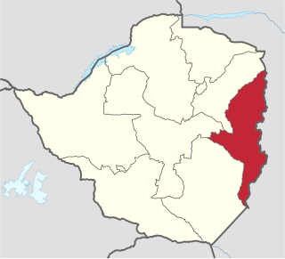
Manicaland is a province in eastern Zimbabwe. After Harare Province, it is the country's second-most populous province, with a population of 1.75 million, as of the 2012 census. After Harare and Bulawayo provinces, it is Zimbabwe's third-most densely populated province. Manicaland was one of five original provinces established in Southern Rhodesia in the early colonial period. The province is divided into ten administrative subdivisions of seven rural districts and three towns/councils, including the provincial capital, Mutare. The name Manicaland is derived from the province's largest ethnic group, the Manyika, a Shona subgroup who speak a distinct Shona dialect, Manyika.

Mutare is the fourth largest city in Zimbabwe, with an urban population of approximately 188,243 and rural population of approximately 260,567. It is the capital of Manicaland province.

Deloraine is a town on the Meander River, in the central north of Tasmania, Australia. It is 50 km west of Launceston and 52 km south of Devonport along the Bass Highway. It is part of the Meander Valley Council. As of 2011, the town of Deloraine had a population of 2,745

The Eastern Highlands, also known as the Manica Highlands, is a mountain range on the border of Zimbabwe and Mozambique. The Eastern Highlands extend north and south for about 300 kilometres (190 mi) through Zimbabwe's Manicaland Province and Mozambique's Manica Province.

The Honde Valley extends from the eastern border of Zimbabwe into Mozambique. The valley is part of the Eastern Highlands. The valley is about 130 kilometres from Mutare, or 110 kilometres from Nyanga. The Nyanga Mountains and the Nyanga National Park forms the western boundary of the valley.

Chimanimani District is a mountainous district in Manicaland Province of eastern Zimbabwe. The district headquarters is the town of Chimanimani.

Nyanga National Park lies in the north of Zimbabwe's Eastern Highlands. One of the first national parks to be declared in the country, it contains the highest land in Zimbabwe, with green hills and perennial rivers. Most of its terrain consists of rolling downland, sometimes lightly wooded, lying at altitudes between 1,800–2,593 metres. Mount Nyangani, the highest point in Zimbabwe, lies in the centre of the park and Mutarazi Falls, Zimbabwe's highest waterfall, is in the south of the park. Nyanga National park incorporates the former Mutarazi Falls National Park on its southern boundary.

Reisa National Park is a national park in Nordreisa Municipality in Troms county, Norway that was established by royal decree on 28 November 1986. The park has much wildlife. The rough-legged buzzard is the most common bird of prey, but hikers may also spot golden eagle, kestrels, and gyrfalcon. Wolverines and lynx live in the park and surrounding mountains. The Sámi name for part of the gorge, Njállaávzi, means Arctic fox gorge, suggesting that the Arctic fox must have lived there a long time. The largest Norwegian predator, the brown bear, is occasionally seen in the park.

Pennsylvania Route 26 is a 125 1⁄2-mile (202.0 km) highway in the south-central area of Pennsylvania. Its northern terminus is at Pennsylvania Route 150 northwest of Howard, Pennsylvania; its southern terminus is at the Maryland state line near Barnes Gap in Union Township. Two major destinations along this route are Raystown Lake near Huntingdon and the Pennsylvania State University at State College.
Hauna is a village in the province of Manicaland, Zimbabwe located in the Honde Valley communal land about 55 km north of Mutare.It is the Growth Point Centre for Mutasa District in Manicaland. Hauna growth point is in Samanga B ward of Mutasa District and has a population of about 8,000. There is an aerodrome where small aeroplanes can land and take off. There is also a Police camp called Ruda Police Station which controls all police activities in Mutasa District.
Mount Selinda, at an altitude of 1,100 metres, is a village and mission station in the province of Manicaland in the eastern mountains of Zimbabwe. Located close to the Mozambique border, it lies in an area of outstanding natural beauty. Mount Selinda sits on an east-facing slope, on the very edge of the Chirinda Forest Botanical Reserve – the southern most tropical rainforest in Africa.
Penhalonga is mining village in Mutasa District of Manicaland Province, Zimbabwe, located 18 km north of Mutare in a valley where the Tsambe and Imbeza Rivers meet the Mutare River. According to the 1982 Population Census, the village had a population of 4,477. Ancient gold workings have been found in the area. In 1895 the Penhalonga Mine opened and the village grew around the gold mine. The name is derived from the shona word Panoronga meaning "the place that shines". The origin is often confused with the Portuguese words "Penha" which means "rocky mountain" and "longa" meaning long. While the old Penhalonga mine closed in 1943, a new mine, the Rezende Mine, opened in 1999. Bauxite clay, which is also mined in the area, supplies most of Zimbabwe's pottery industry. The village is the residential and commercial centre for the mine and the surrounding area of forestry, dairy and mixed farming.
Watsomba is a shopping centre in the province of Manicaland, Zimbabwe located 42 km north of Mutare on the main Mutare-Nyanga road. It is an administrative and trading centre for Mutasa District and the Mutasa and Manyika communal lands. Around Watsomba are farms surrounding the growth point namely ruwodo farm, muringami farm, sakupwanya farm, madziwa farm, sagonda farm, Mutasa farm, Mandimutsira farms, Mundoma farm, Mvere Farm,Nyakurukwa Farm and Makoni Farm.
Chisumbanje is an area in the Province of Manicaland, Zimbabwe. It is situated in Chipinge District, one of the seven districts in Manicaland Province. It is located in the Dowoyo communal land on the eastern bank of the Save River, about 95 km (59 mi) south of Birchenough Bridge on the Birchenough Bridge-Chiredzi road.

The Bvumba Mountains or Vumba Mountains straddle the Zimbabwe-Mozambique border, and are situated some 10 km south east of Mutare. The Bvumba rise to Castle Beacon at 1,911 metres, and are, together with the Chimanimani Mountains to the south and Nyanga Mountains to the north, part of the Eastern Highlands of the Manicaland and adjacent Manica provinces. They are referred to as the "Mountains of the Mist", as so often the early morning starts with a mist which clears by mid-morning. Although lying mostly within Zimbabwe, the mountains extend north-eastward to Mount Vumba in Mozambique. They are capped by cool, green hills which shelter country hotels, a casino and golf course at the Leopard Rock Hotel and a Botanical Garden with one of the best views in Africa. The mountains are also known for their coffee plantations.
Communal land is a territory in possession of a community, rather than an individual or company . This sort of arrangement existed in almost all Europe until the 18th century, by which the king or the church officially owned the land, but allowed the peasants to work in them in exchange for a levy. These institutions still survive today in Switzerland and Sardinia.

Mutasa District is one of seven districts in Manicaland Province of Zimbabwe. Mutasa District is located 30 km northeast Mutare and stretches up to the Honde Valley, which is about 100 km northeast of Mutare along a tarred road that branches off the Nyanga road.
Breakneck Brook, sometimes Breakneck Valley Brook, is a 1.7-mile-long (2.8 km) tributary of the Hudson River located entirely in the Putnam County town of Philipstown, New York, United States. It rises at Surprise Lake and flows southwest towards the Hudson from there, mostly through Hudson Highlands State Park. The name comes from Breakneck Ridge to its north.
Mutare District is a district in Manicaland Province of eastern Zimbabwe. The district headquarters is the city of Mutare.
