Burra Bee Dee Mission

Last updated

Burra Bee Dee Mission
Australia New South Wales relief location map.png
Red pog.svg
Location of Burra Bee Dee Mission in New South Wales
LocationOxley Highway, Coonabarabran, Warrumbungle Shire, New South Wales, Australia
Coordinates 31°14′07″S149°20′41″E / 31.2353°S 149.3448°E / -31.2353; 149.3448
Built18921957
OwnerCoonabarabran Local Aboriginal Land Council; Department of Trade & Investment, Regional Infrastructure & Services
Official nameBurra Bee Dee Mission; Forked Mountain
TypeState heritage (built)
Designated4 June 2004
Reference no.1688
TypeSite complex
CategoryAboriginal

Burra Bee Dee Mission is a heritage-listed former Indigenous Australian mission, still in use as a cemetery on the Oxley Highway at Coonabarabran in the Orana region of New South Wales, Australia. It was built from 1892 to 1957. It is also known as Forked Mountain. The property is owned by Coonabarabran Local Aboriginal Land Council and the Department of Trade & Investment, Regional Infrastructure & Services (State Government). It was added to the New South Wales State Heritage Register on 4 June 2004. [1]

Contents

History

Burra Bee Dee Mission was founded in 1908. In 1892 Mary Jane Cain who originally lived on the river bank close to town who used to run goats of which would get away from her and head to Forky Mountain. It was this that eventually made Cain and husband to build a place out at Forked Mountain for her to stay. Cain wrote to Queen Victoria on numerous occasions requesting that the land was to be granted to her. Queen Victoria granted that Burra Bee Dee or part thereof be handed to Cain and Queen Victoria requested that Mary Jane was to manage the property and was required to provide a place for the dark people (sic) to live on. The land there was later reserved for Aboriginal use and in the early 1900 was brought under the control of the Aboriginal Protection Board and became a managed station. Burra Bee Dee Aboriginal Reserve was gazetted on the 21 February, and it was made of three reserves in existence: in 1892, one of 160 hectares (400 acres); in 1906, one of 30 hectares (73 acres); and in 1911, one of 40 hectares (100 acres). Other major camps in the Coonabarabran area that were not under the Board control included the showgrounds and Gunnedah Hill. [1]

Burra Bee Dee was originally known as Forky Mountain after the hill that dominates the landscape. The mountain was the reason for Cain's visit to the place to shepherd her goats back to Coonabarabran. The land which was originally granted to Cain was officially known as Forky Mountain until the name was changed to Burra Bee Dee somewhere around 1911. The significance of the name Burra Bee Dee is an Aboriginal word meaning flying mice. Just as the Mountain is a significant and organising feature of the landscape it is often a significant and organising feature of the language, the stories of Burra Bee Dee. Forky Mountain was significant to the people of Burra Bee Dee as it was a birthplace, a place for burials and a food source. [1]

The first hut on the mission was built by Cain and her husband which was a boarded house with tin and bark and a dirt floor. With the influx of Cain's extended family and other families from around the district peoples dwellings ranged from bag houses made of Hessian bags, tents, and bark and kerosene – tin shacks. To the two roomed fibro houses built during the peak of the managers days. The shacks were built in clusters and added to when needed. The clusters were known by the women who ran them Granny Cain, Queenie's place and Granny Fuller's. The only houses built in rows facing the road were the five or six fibro houses that the government built in later times. [1]

Not only was the Burra Bee Dee mission used by Aboriginal people as a place for dwelling other areas such as Gunnedah Hill and Coonabarabran Showground were also other places of dwelling. Although neither groups in the beginning liked each other they all eventually ended up living at Burra Bee Dee. [1]

In 1924 two women came to Burra Bee Dee as Missionaries. They lived and worked with the people for 30 years and were very much an institution in Burra Bee Dee life. Mr Marney one of the Burra Bee Dee residents built the church for the missionaries to live in on the mission. The women held sewing classes which every year they held a show. Church was held every Sunday morning with Sunday school in the morning for the children and church of an afternoon. [1]

Description

The site covers approximately 628 hectares (1,550 acres) of land which includes the mountain known as Forky Mountain. Throughout the area there is no physical buildings, remains or objects of former dwellings such as housing, school or the church. [1]

The only remaining site at Burra Bee Dee Mission is the cemetery which is still currently being used by the local community. [1]

In the early 1970s the original school house was removed and is being used for private use. [1]

As at 16 January 2004, certain specific areas within the boundary were reported to have high potential for archaeological evidence. These included the main area of the mission and surroundings and at the base of Forky Mountain. [1]

The community would like to preserve the area and enable educational visits and tours to the area to promote Aboriginal heritage. Enhancements such as an interpretation trail around the main area of the mission and possibly a cultural centre to house the memorabilia and artefacts and educational information about life on the mission. [1]

Heritage listing

Burra Bee Dee Mission and Forky Mountain is of State significance as it maintains and continues to show the historical process and activities and is a place of occupancy of Aboriginal people from the district. The site is associated to a significant historical phase of NSW as it was land granted to an Aboriginal woman, Cain in the early 1900s by Queen Victoria and gazetted in 1911 as an Aboriginal Reserve. The area is able to demonstrate the strong associations to past customs and provides an understanding of cultural practices that were undertaken. The site of Burra Bee Dee mission, the cemetery and Forky Mountain is associated to the Gamilaraay people as a significant place as it is the original site of occupation for many Aboriginal people, it is associated to the memory of Mary Jane Cain and it is a place of cultural, spiritual, historical and social values. [1]

Burra Bee Dee Mission was listed on the New South Wales State Heritage Register on 4 June 2004 having satisfied the following criteria. [1]

"The place is important in demonstrating the course, or pattern, of cultural or natural history in New South Wales."

Burra Bee Dee Mission and Forky Mountain shows evidence of the activity that was undertaken by the local Aboriginal people. Founded by Mary Jane Cain in 1892, and formerly known as Forky Mountain, Burra Bee Dee Mission became a home to many Aboriginal people across the district. Originally granted to Cain in the early 1900s by Queen Victoria, the area was gazetted in 1911 as an Aboriginal Reserve and the named changed to Burra Bee Dee Mission. The area is of State significance as it is able to demonstrate strong associations to past customs and provides an understanding of a historical phase of the Gamilaraay people and cultural practices that were undertaken. The Gamilaraay people continue to visit the site to undertake cultural practices and maintain the original cemetery which is still used today. The relationship to that of Forky Mountain also has not only a spiritual connection to the Gamiliaraay people but a connection to land as Forky Mountain played a significant role in the occupation sites within the Mission. [1]

"The place has a strong or special association with a person, or group of persons, of importance of cultural or natural history of New South Wales's history."

Burra Bee Dee came about the efforts of one Aboriginal woman, Cain. Due to a flock of wandering goats, Cain and her family made Forky Mountain their home in the late 1800s. Through the efforts and persistence of Cain, Burra Bee Dee was formalised in 1911 and became a place of occupation and food for the local Aboriginal people and Aboriginal people from around the district. Burra Bee Dee became an important centre for the local Gamilaraay people and a significant place of occupation. The site of Burra Bee Dee mission, the cemetery and Forky Mountain is associated to the Gamilaraay people as a significant place as it is the original site of occupation for many Aboriginal people, it is associated to the memory of Cain and it is a place of cultural, spiritual, historical and social values. [1]

"The place has a strong or special association with a particular community or cultural group in New South Wales for social, cultural or spiritual reasons."

Burra Bee Dee and Forky Mountain has a strong and special association for the Gamilaraay people for its social, cultural and spiritual values. The area is well known for its linkages with dreaming stories and Forky Mountain is often a significant and organising feature of the language and the stories. Forky Mountain was a special place for being "born under the mountain" and being buried at the 'foot of the mountain and it was a special place of the "Sun Dance", a ritual that occurred every Easter Sunday, where many would climb to the tip of the mountain to watch the sun dance. Burra Bee Dee and Forky Mountain is a place of importance and belonging to the Gamilaraay people. [1]

"The place has potential to yield information that will contribute to an understanding of the cultural or natural history of New South Wales."

The base of Forky Mountain has the potential to yield new archaeological information and provide evidence of past human cultural activities. Further documentation of oral histories of elders and collection of memorbila and interpretation of the area will further enhance the documentation that is already provided. [1]

"The place is important in demonstrating the principal characteristics of a class of cultural or natural places/environments in New South Wales."

Burra Bee Dee and Forky Mountain is highly significant to the Gamilaraay people to their cultural heritage values. The area is outstanding as it is able to demonstrate the principal characteristics of the Gamilaraay people. Being the site of the original settlement at the base of Forky Mountain and then later the gazette "Mission" site, the area has the attributes to demonstrate the way of life and customs of the Gamilaraay people. Although there are no physical buildings remaining, the original cemetery is all that remains and is maintain and used by the local Aboriginal community. [1]

See also

Related Research Articles

<span class="mw-page-title-main">Kamay Botany Bay National Park</span> Protected area in New South Wales, Australia

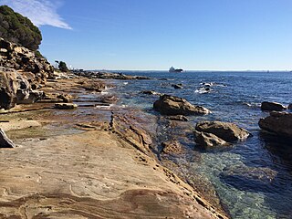
The Kamay Botany Bay National Park is a heritage-listed protected national park that is located in the eastern part of Botany Bay in Sydney, New South Wales, Australia. The 456-hectare (1,130-acre) national park is situated approximately 16 kilometres (9.9 mi) south-east of the Sydney central business district, on the northern and southern headlands of Botany Bay. The northern headland is at La Perouse and the southern headland is at Kurnell.

<span class="mw-page-title-main">Coonabarabran</span> Town in New South Wales, Australia

Coonabarabran is a town in Warrumbungle Shire that sits on the divide between the Central West and North West Slopes regions of New South Wales, Australia. At the 2021 census, the town had a population of 2,387, and as of 2021, the population of Coonabarabran and its surrounding area is 3,477. Local and district residents refer to the town as 'Coona'. Coonabarabran is the gateway to the Warrumbungle National Park, Siding Spring Observatory and the Pilliga Forest.

<span class="mw-page-title-main">Collarenebri</span> Town in New South Wales, Australia

Collarenebri is a town in north western New South Wales, Australia. The town is in the Walgett Shire Local Government Area and is situated on the Barwon River approximately 75 kilometres (47 mi) northeast of Walgett and south west of Mungindi on the Gwydir Highway. It is 16 km (9.9 mi) from Pokataroo which was the nearest railway town prior to closure of the rail service there. The town is 150 metres (490 ft) above sea level. Collarenebri is one of three towns ending in 'BRI' in Northern New South Wales.

<span class="mw-page-title-main">Warrumbungle Shire</span> Local government area in New South Wales, Australia

The Warrumbungle Shire is a local government area in the central western region of New South Wales, Australia. The Shire is traversed by the Newell Highway. The Warrumbungle mountain range and Warrumbungles National Park are major tourist attractions for the Shire. Its seat is located in Coonabarabran, a town in the southwest.

<span class="mw-page-title-main">Awabakal</span> Australian Aboriginal people of mid north coastal New South Wales

The Awabakal people, are those Aboriginal Australians who identify with or are descended from the Awabakal tribe and its clans, Indigenous to the coastal area of what is now known as the Hunter Region of New South Wales. Their traditional territory spread from Wollombi in the west, to the Lower Hunter River near Newcastle and Lake Macquarie in the north.

<span class="mw-page-title-main">Mary Jane Cain</span> Australian human rights activist

Mary Jane Cain (1844–1929) was a community leader, a Gomeroi woman who lived in the Coonabarabran region of New South Wales. She was born in 1844 and was instrumental in the establishment of the Burra Bee Dee Aboriginal Reserve in 1912 and came to be known as the Queen of Burrabeedee or "Queenie Cain".

<span class="mw-page-title-main">Cliefden Caves</span> Protected area in New South Wales, Australia

The Cliefden Caves is a heritage-listed geoheritage site in Mandurama, Cowra Shire, New South Wales, Australia. The caves comprise Ordovician fossil localities, limestone caves, a spring and tufa dams, and a site where limestone was first discovered in inland Australia.

The Collarenebri Aboriginal Cemetery is a heritage-listed cemetery and ceremonial site for Indigenous Australians located at Gundabloui Road, Collarenebri, Walgett Shire, New South Wales, Australia. It was built from 1907. The property is owned by Collarenebri Local Aboriginal Land Council. The site was added to the New South Wales State Heritage Register on 19 December 2014.

The Wooleybah Sawmill and Settlement is a heritage-listed former small settlement and sawmill at Old Wooleybah Road, Kenebri, Warrumbungle Shire, New South Wales, Australia. It was built from 1935 by the Underwood family. It is also known as Wooleybah Dead Man's Waterhole. The property is owned by Forestry Commission of NSW, an agency of the Government of New South Wales. It was added to the New South Wales State Heritage Register on 17 December 2010.

<span class="mw-page-title-main">Prospect Post Office</span> Historic site in New South Wales, Australia

Prospect Post Office is a heritage-listed former post office and shop at 23 Tarlington Place, Prospect, City of Blacktown, New South Wales, Australia. It was designed by James Watts and built by Watts from 1880 to 1890. The property is owned by the City of Blacktown. It was added to the New South Wales State Heritage Register on 2 April 1999.

<span class="mw-page-title-main">St Bartholomew's Anglican Church and Cemetery, Prospect</span> Church in New South Wales, Australia

St Bartholomew's Anglican Church and Cemetery is a heritage-listed former Anglican church and cemetery at Ponds Road, Prospect, City of Blacktown, New South Wales, Australia. It was designed by Henry Robertson and built from 1838 to 1840 by James Atkinson. It was added to the New South Wales State Heritage Register on 2 April 1999. Since 1975, the site has been leased to the Council of the City of Blacktown.

The Wellington Convict and Mission Site is a heritage-listed former convict agricultural station, Australian Aboriginal mission and cemetery located at Curtis Street, Wellington in the Dubbo Regional Council local government area in New South Wales, Australia. It was built between 1823 and 1844. It is also known as Wellington Convict and Mission Site – Maynggu Ganai, Wellington Valley Settlement, Wellington Aboriginal Mission and Government Farm Site. The property was added to the New South Wales State Heritage Register on 22 March 2011.

Blacks Camp is a heritage-listed area in New South Wales, Australia. It is significant for its historical connections to the Wiradjuri indigenous people during the colonial era and early twentieth century, when the camp site formed part of a Christian mission station. Located on University Road, Wellington in the Central West region of the state, it is also known as The Spring Flats. Today the site is mostly vacant and agricultural land, including a residence owned by New South Wales Land and Property Information (LPI), an agency of the Government of New South Wales. The property was added to the New South Wales State Heritage Register on 18 November 2011.

<span class="mw-page-title-main">Brewarrina Aboriginal Mission Site</span> Historic site in New South Wales, Australia

Brewarrina Aboriginal Mission Site is a heritage-listed site of the former mission station for Aboriginal Australians and cemetery at The Old Mission Road, Brewarrina, New South Wales, Australia. It was also known as Barwon Mission, Brewarrina Mission and Brewarrina Aboriginal Station. Built from 1880, it was added to the New South Wales State Heritage Register on 21 July 2006.

<span class="mw-page-title-main">Ulgundahi Island</span> Historic site in New South Wales, Australia

Ulgundahi Island is a heritage-listed Aboriginal site, formerly an occupational settlement, with ongoing usage as farmland and as a site of ongoing significance, at Clarence River by North Arm, Maclean, Clarence Valley Council, New South Wales, Australia. The property is owned by the Yaegl Local Aboriginal Land Council. It was added to the New South Wales State Heritage Register on 24 December 2004.

<span class="mw-page-title-main">Currango Homestead</span> Historic site in New South Wales, Australia

Currango Homestead is a heritage-listed farm and homestead at Tantangara in the Kosciuszko National Park, Snowy Monaro Regional Council, New South Wales, Australia. The property is owned by the Office of Environment and Heritage. It was added to the New South Wales State Heritage Register on 2 April 1999.

<span class="mw-page-title-main">Warangesda Aboriginal Mission</span> Historic site in New South Wales, Australia

The Warangesda Aboriginal Mission is a heritage-listed former Australian Aboriginal mission site at Warangesda, Darlington Point, Murrumbidgee Council, New South Wales, Australia. The mission was designed and built between 1880 and 1926. It is also known as Warangesda Aboriginal Mission and Station, Warangesda Mission, Warangesda Aboriginal Station, and Warrangesda. It was added to the New South Wales State Heritage Register on 9 July 2010. The Naden family as well as Florence (Cot) Johnson also lived at Warangesda.

<span class="mw-page-title-main">Hill 60, Port Kembla</span> Aboriginal heritage site in New South Wales

Hill 60 is a heritage-listed Aboriginal site at Military Road, Port Kembla, City of Wollongong, New South Wales, Australia. It is also the location of the World War II installation the Illowra Battery. The property is owned by Wollongong City Council. It was added to the New South Wales State Heritage Register on 14 December 2001.

Googong Foreshores is a heritage-listed historic precinct at London Bridge Road, Burra, New South Wales, Australia. It consists of the historic surroundings of the Googong Dam that predated the dam itself. It is also known as the Googong Foreshores Cultural and Geodiversity Heritage Areas. It was added to the Australian Commonwealth Heritage List on 3 November 2017.

Earlwood Aboriginal Art Site is a heritage-listed Aboriginal cultural site at Earlwood, City of Canterbury-Bankstown, New South Wales, Australia. It is also known as Aboriginal Art and Midden. It was added to the New South Wales State Heritage Register on 27 November 2009.

References

  1. 1 2 3 4 5 6 7 8 9 10 11 12 13 14 15 16 17 18 "Burra Bee Dee Mission". New South Wales State Heritage Register . Department of Planning & Environment. H01688. Retrieved 2 June 2018. CC BY icon.svg Text is licensed by State of New South Wales (Department of Planning and Environment) under CC-BY 4.0 licence .

Bibliography

Attribution

CC BY icon-80x15.png This Wikipedia article was originally based on Burra Bee Dee Mission , entry number 01688 in the New South Wales State Heritage Register published by the State of New South Wales (Department of Planning and Environment) 2018 under CC-BY 4.0 licence , accessed on 2 June 2018.