View of Burt Street, Boulder. The Court Hotel in on the left
Burt Street is the main street in Boulder, Western Australia. It runs between Gatacre Drive in the west, and the junction and roundabout at Hamilton Street, across from what had been Boulder railway station and is now the Loopline railway station. A separate section on the other side of the railway line continues to Goldfields Highway.
The three blocks, between Hamilton Street, Brookman Street and Lionel Street have the history of Boulder commercial and administrative activity and heritage in the buildings.[1][2][3][4]
Kalgoorlie is a city in the Goldfields–Esperance region of Western Australia, located 595 km (370 mi) east-northeast of Perth at the end of the Great Eastern Highway. It is sometimes referred to as Kalgoorlie–Boulder, as the surrounding urban area includes the historic townsite of Boulder and the local government area is the City of Kalgoorlie–Boulder.
Fyansford is a township on the western edge of Geelong, Victoria, Australia, named after Captain Foster Fyans who came to Geelong as a Police magistrate in October, 1837. It is located at the junction of the Barwon and Moorabool rivers. At the 2016 census, Fyansford had a population of 196.
North Fremantle is a suburb of Perth, Western Australia, located within the City of Fremantle, a local government area of the state. Its postcode is 6159.
Eagle Farm is an eastern industrial suburb of the City of Brisbane, Queensland, Australia. In the 2021 census, Eagle Farm had a population of 11 people.
Hamilton railway station is a heritage-listed railway station on the Newcastle line in the inner Newcastle suburb of Hamilton in New South Wales, Australia. It was added to the New South Wales State Heritage Register on 2 April 1999.
Barrack Square is an open public square on the foreshore of Perth Water on the Swan River, located at the southern end of Barrack Street near the central business district of Perth, Western Australia.
Wellington Street is the northernmost of the four primary east-west streets in the central business district of Perth, Western Australia. It is 3.7 kilometres (2.3 mi) long, stretching from Plain Street in East Perth to Thomas Street in West Perth.
Queen Victoria Street is the main road entering the city centre of Fremantle, Western Australia, from the direction of Perth. The road was originally named Cantonment Road, but was subsequently renamed Victoria Road, and a few years later Queen Victoria Street, after Queen Victoria of the United Kingdom, to avoid confusion with similarly named roads in the area.
The City of Kalgoorlie–Boulder is a local government area in the Goldfields–Esperance region of Western Australia, about 550 kilometres (342 mi) east of the state capital, Perth. Covering an area of 95,575 square kilometres (36,902 sq mi), the city is the 12th largest in the world, larger than the country of Portugal with a land area of 92,212 square kilometres (35,603 sq mi). Its seat of government is the town of Kalgoorlie; all but 244 of the city's population live in either Kalgoorlie or Boulder.
Kalgoorlie railway station is the easternmost attended station in Western Australia, located at the eastern terminus of the Eastern Goldfields Railway. It serves the city of Kalgoorlie. Beyond Kalgoorlie, the line continues east as the Trans-Australian Railway.
Bulong is an abandoned town in Western Australia located 580 kilometres (360 mi) east of Perth in the Goldfields-Esperance region of Western Australia.
Barrack Street Bridge is the second crossing of the Eastern Railway line at its location just north of the Barrack Street intersection with Wellington Street at the eastern end of the Perth Railway Station yard in Perth, Western Australia. Despite its name the bridge carries Beaufort Street, although it has been called Beaufort Street Bridge.
The York Hotel is a heritage hotel on Hannan Street, in Kalgoorlie, Western Australia.
Hannan Street is the main street in the goldfields town of Kalgoorlie, Western Australia, and the easternmost section of Great Eastern Highway. It is 3.2 kilometres (2 mi) long and named after one of the founding fathers of the town, Paddy Hannan.
The Helena Vale Racecourse was a Thoroughbred horse racing track in the eastern suburb of Perth, Western Australia now known as Midvale. The course operated from the 1890s until the late 1960s.
Pakenham Street is a street in Fremantle, Western Australia, in the Fremantle West End Heritage area. It runs between Phillimore Street and Collie Street, the main cross intersection being with High Street.
Beach Street in a street located in Fremantle, Western Australia. It runs along the historic southern shore of the Swan River, south-east of the inner harbour, between Parry Street and East Street.
Roe Street is a street in Perth, Western Australia. The central section of the street forms the southern boundary of the suburb of Northbridge, while the eastern end borders the Perth Cultural Centre to the north and Perth railway station to the south. The southern approach of the Hamilton Interchange, which connects the Mitchell Freeway and the Graham Farmer Freeway, passes over the street to the west.
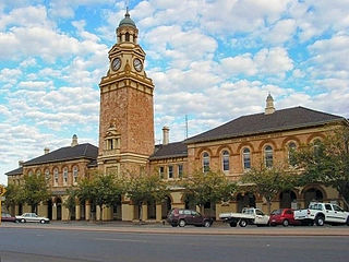
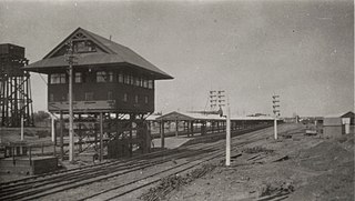
Boulder railway station was part of the Boulder loopline, a railway that commenced at the Kalgoorlie railway station and travelled south for the purpose of transporting workers to the mines on the Golden Mile in Kalgoorlie-Boulder in Western Australia.
Perth marshalling yard was a railway marshalling yard to the immediate west of Perth railway station in Perth, Western Australia and east of West Perth railway station.
This page is based on this Wikipedia article Text is available under the CC BY-SA 4.0 license; additional terms may apply. Images, videos and audio are available under their respective licenses.