Beaver Creek may refer to:
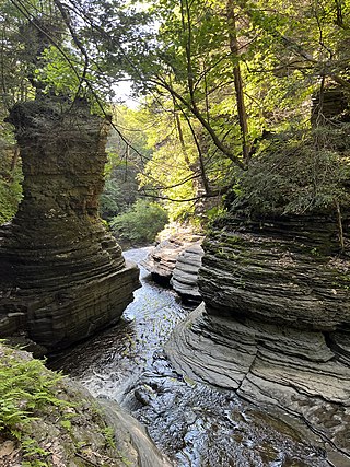
Buttermilk Falls State Park is a 811-acre (3.28 km2) state park located southwest of Ithaca, New York, United States. Like Robert H. Treman State Park, a portion of the land that was to become the state park came from Robert and Laura Treman in 1924.

The Raquette River, sometimes spelled Racquette, originates at Raquette Lake in the Adirondack Mountains in the U.S. state of New York. 146 miles (235 km) long, it is the third longest river entirely in the state of New York.

Schoharie Creek is a river in New York that flows north 93 miles (150 km) from the foot of Indian Head Mountain in the Catskills through the Schoharie Valley to the Mohawk River. It is twice impounded north of Prattsville to create New York City's Schoharie Reservoir and the Blenheim-Gilboa Power Project.
Sweetwater Creek is a 45.6-mile-long (73.4 km) stream in the U.S. state of Georgia, west of Atlanta. It begins in southwestern Paulding County, flowing generally eastward into southwestern Cobb County, then turning south into eastern Douglas County. It is a tributary of the Chattahoochee River, and near its end it is the centerpiece of Sweetwater Creek State Park.

Robinson Township is a township in Brown County, Kansas, USA. As of the 2000 census, its population was 452.

Peekamoose Mountain is a mountain located in Ulster County, New York. The mountain is part of the Catskill Mountains. Peekamoose Mountain is flanked to the north by Table Mountain. The name Peekamoose is possibly an anglicization of an Algonquin word meaning 'broken off smooth', cf. Poke-O-Moonshine Mountain.
Buttermilk is an unincorporated community in Pope County, Arkansas, United States. The community's name was derived from an observer who saw the whitewash run off the Cumberland Presbyterian Church during a rain storm in 1840 and commented that it looked like buttermilk.
Buttermilk Creek may refer to:
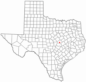
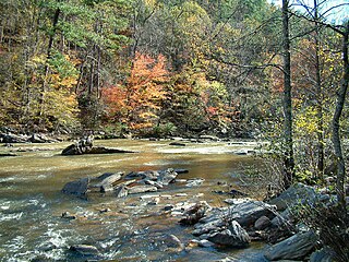
The Buttermilk Creek complex is the remains of a paleolithic settlement along the shores of Buttermilk Creek in present-day Salado, Texas. The assemblage dates to ~13.2 to 15.5 thousand years old. If confirmed, the site represents evidence of human settlement in the Americas that pre-dates the Clovis culture.
Yatesville Creek is a river in Montgomery County in the state of New York. It begins northeast of Charleston Four Corners and flows in a general northwest direction before converging with the Mohawk River in Randall. The creek flows through the 712 acres (2.88 km2) Yatesville Falls State Forest which was purchased by the state in the 1930s. Within the state forest is Yatesville Falls, also known as Buttermilk Falls, is located on the creek. On a land grant, dated 1727, it is referred to by the Indian name "Wasontha".
Caroga Creek is a river in Fulton and Montgomery counties in the U.S. State of New York. It begins at East Caroga Lake and flows south passing through Rockwood Lake before converging with the Mohawk River in the Hamlet of Palatine Church.
The Schenevus Creek is a river located in southern Otsego County, New York. The creek flows through Worcester and Schenevus before converging with the Susquehanna River in Colliersville, New York.
Red Creek is a river located in central Otsego County, New York. The creek converges with the Susquehanna River south of Cooperstown, New York.
Charlotte Creek is a river located in Delaware County, New York. Charlotte Creek borders the southern border of Otsego County, New York for a few miles near the mouth. The creek converges with the Susquehanna River by Emmons, New York.
Panther Mountain is a mountain located in Central New York of New York near Fly Creek, New York and Schuyler Lake, New York. The east side of Panther Mountain drains into Fly Creek and the west side drains into Oaks Creek and Canadarago Lake.
Gifford Hill is a small mountain chain in the Central New York Region of New York. It is located northeast of Oneonta, New York. It is made of three main peaks the highest being 1928 feet. Gifford Hill is named for the Gifford Family who moved to the area in 1803 and settled along the Oneonta Creek on what is now called Gifford Hill.
Danby is the primary hamlet and a census-designated place (CDP) in the town of Danby, Tompkins County, New York, United States. It was first listed as a CDP prior to the 2020 census.

