Byalya is a village in Madhugiri Taluk, Tumkur district, Karnataka State in India with the PIN Code 572175
Byalya is a village in Madhugiri Taluk, Tumkur district, Karnataka State in India with the PIN Code 572175
This is a list of the extreme points of the United Kingdom: the points that are farther north, south, east or west than any other location. Traditionally the extent of the island of Great Britain has stretched "from Land's End to John o' Groats".

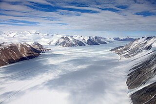
Ferrar Glacier is a glacier in Antarctica. It is about 35 nautical miles long, flowing from the plateau of Victoria Land west of the Royal Society Range to New Harbour in McMurdo Sound. The glacier makes a right (east) turn northeast of Knobhead, where it where it is apposed, i.e., joined in Siamese-twin fashion, to Taylor Glacier. From there, it continues east along the south side of Kukri Hills to New Harbor.

Santiago Texacuangos is a municipality in the San Salvador department of El Salvador. It is near Lake Ilopango.
Vadakkuvalliyur is a panchayat town in Tirunelveli district in the Indian state of Tamil Nadu.

Cenizate is a municipality in Albacete, Castile-La Mancha, Spain. It has a population of 1,143. The former professional cyclist Roque de la Cruz was born here.

This is a list of the extreme points of Azerbaijan, the points that are farther north, south, east or west than any other location.

Valaliky is a relatively new village and municipality in Košice-okolie District in the Kosice Region of eastern Slovakia.
Cavaillon or Cavaellon is a commune and a rural town located in the Aquin Arrondissement of the Sud department of Haiti.
Bio reserved of india full map of india

Hut Point Peninsula is a long, narrow peninsula from 2 to 3 nautical miles wide and 15 nautical miles long, projecting south-west from the slopes of Mount Erebus on Ross Island, Antarctica. McMurdo Station (US) and Scott Base (NZ) are Antarctic research stations located on the Hut Point Peninsula.

Pupiales is a town and municipality in the Nariño Department, Colombia.

Calatayud is a Spanish Denominación de Origen Protegida (DOP) for wines located in the southwestern corner of the province of Zaragoza about 90 km from Zaragoza and covers over 5,600 ha, extending over 46 different municipalities, including Calatayud itself. It borders with the Cariñena (DO) in the east and with the province of Soria in the west. It is in the Ebro River valley and is crisscrossed by many of the Ebro's tributaries including the Jalón, Jiloca, Manubles, Mesa (river), Piedra and Ribota. The vineyards are found on the south facing slopes of the Sierra de la Virgen range at heights of between 550 m and 800 m above sea level.

Washington Air Route Traffic Control Center (ZDC) is an Area Control Center operated by the Federal Aviation Administration and located at Lawson Rd SE, Leesburg, Virginia, United States. The primary responsibility of ZDC is the separation of airplane flights and the expedited sequencing of arrivals and departures along STARs and SIDs for the Washington-Baltimore Metropolitan Area, the New York Metropolitan Area, and Philadelphia among many other areas.

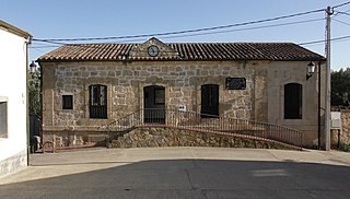
Cuelgamures is a municipality located in the province of Zamora, Castile and León, Spain. According to the 2019 census (INE), the municipality has a population of 85 inhabitants.

The Firnley Islands is a group of three small islands covered with tundra vegetation and with scattered stones on their shores. They lie in the Kara Sea, close to the bleak coast of Siberia's Taymyr Peninsula, not far east of the Nordenskjold Archipelago. These islands lie about 35 km from the continental shore.
Yuxarı Amburdərə is a village in the Lerik District of Azerbaijan. The village forms part of the municipality of Ashaghy Amburdere.

Asipovichy District or Asipovičy District is a district (raion) of Mogilev Region in Belarus. Its administrative center is the town of Asipovichy. In 2009, its population was 52,447; the population accounted for 62.0% of the district's population. As of 2024, it has a population of 43,365.

Raugi is a village in Muhu Parish, Saare County in western Estonia.
Kavalgeri is a village in Dharwad district of Karnataka, India.