Mo i Rana is a town and the administrative centre of the municipality of Rana in Nordland county, Norway. It is located in the Helgeland region of Nordland, just south of the Arctic Circle. Some of the outlying areas of the town include the suburbs of Båsmoen and Ytteren in the north and Selfors in the east and Åga/Hauknes/Dalsgrenda in the south.

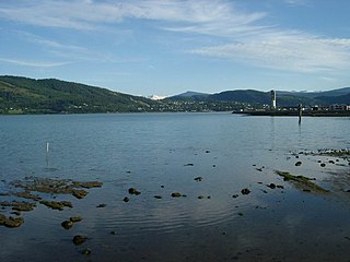
The Ranfjorden is a fjord in the Helgeland district of Nordland county, Norway. The largest part of the fjord is in the municipality of Rana, but the fjord also passes through the municipalities of Hemnes, Vefsn, Leirfjord, Nesna, and Dønna. The river Ranelva meets the Ranfjord in at the town of Mo i Rana at the innermost part of the fjord. It then flows to the west for about 68 kilometres (42 mi) to where it meets the sea along the border of Dønna and Nesna municipalities.
Bjørnefossvatnet or Flatisvatnet is a lake in the northwestern part of the municipality of Rana in Nordland county, Norway. The lake is located inside the Saltfjellet–Svartisen National Park, about 30 kilometres (19 mi) north of the town of Mo i Rana. The glacial lake is also the headwaters of the Glomåga river which flows south into the lake Langvatnet.
Bogvatnet (Norwegian) or Tjoamodisjávrre (Lule Sami) is a lake in the municipality of Rana in Nordland county, Norway. The lake is located inside the Saltfjellet–Svartisen National Park, about 40 kilometres (25 mi) north of the town of Mo i Rana. The glacial lake is also the headwaters of the Blakkåga river, a tributary to the main river Ranelva.

Langvatnet is a lake in the municipality of Rana in Nordland county, Norway. The 26.38-square-kilometre (10.19 sq mi) lake lies just northwest of the town of Mo i Rana. The lake flows out into the river Langvassåga just north of Mo i Rana Airport, Røssvoll. The lake used as a reservoir for the Langvatn hydroelectric power plant in the village of Ytteren, just down the hill from the lake.
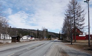
Dunderland is a village in the Dunderland Valley in the municipality of Rana in Nordland county, Norway. The village is located along the Ranelva river, about 10 kilometres (6.2 mi) northeast of the village of Eiteråga and about 40 kilometres (25 mi) from the town of Mo i Rana.

Nord-Rana is a former municipality in Nordland county, Norway. The 3,980-square-kilometre (1,540 sq mi) municipality existed from 1839 until its dissolution in 1964. From 1839 until 1844, it was named Nord-Ranen, from 1844 until 1923, it was called Mo, and then from 1923 until 1964 it was named Nord-Rana. The former municipality was located at the innermost part of the Ranfjorden. It encompassed the eastern 90% of what is now Rana Municipality. The administrative centre was the village of Ytteren, just north of the town of Mo i Rana.
Myklebustad or Myklebostad is a village in the municipality of Rana in Nordland county, Norway. It is located along Norwegian County Road 17 on the southern bank of the Sjona fjord, just west of the villages of Mæla and Utskarpen. Sjona Church is located in the western part of Myklebustad, serving the western part of Rana municipality.
Mæla is a village in the municipality of Rana in Nordland county, Norway. It is located along Norwegian County Road 17 at the eastern end of the Sjona fjord, about 2 kilometres (1.2 mi) north of the villages of Utskarpen and Myklebustad.

Mo i Rana Airport, Røssvoll is a regional airport serving the town of Mo i Rana in the municipality of Rana in Nordland county, Norway. The airport is located about 10 kilometres (6.2 mi) outside the town in the village of Røssvoll. In 2014 Mo i Rana Airport served 104,474 passengers. It is operated by Avinor.

Selfors is a village in the municipality of Rana in Nordland county, Norway. Selfors sits on the northern shore of the river Ranelva and it is a northeastern suburb of the town of Mo i Rana. The European route E06 highway passes through the village. Selfors has been inhabited since the Iron age.
Utskarpen is a village in the municipality of Rana in Nordland county, Norway, about 37 kilometres (23 mi) west of the town of Mo i Rana. The village is located at the end of the Utskarpen fjord, an arm of the main Ranfjorden. On the western side of Utskarpen is the intersection with Norwegian County Road 17 and Norwegian County Road 12. The neighboring villages are Mæla to the north and Myklebustad to the west.

Mo i Rana Station is a railway station located in the town of Mo i Rana in the municipality of Rana in Nordland county, Norway. The station is located along the Nordland Line and has been in operation since 1942. Since 10 January 1943, Norsk Spisevognselskap has operated a restaurant at the station.
Skonseng is a village in the municipality of Rana in Nordland county, Norway. The village is located about 10 kilometres (6.2 mi) northeast of the town of Mo i Rana in an agricultural area with a population of about 1000. The village is located along the south side of the river Ranelva where three valleys meet each other: the Dunderland Valley, Plurdal, and Rødvassdal. The village of Røssvoll lies on the north side of the river, just across from Skonseng. The Nordland Line passes through the village.
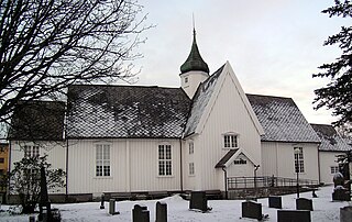
Mo Church is a parish church of the Church of Norway in Rana Municipality in Nordland county, Norway. It is located in the town of Mo i Rana. It is the church for the Mo parish which is part of the Indre Helgeland prosti (deanery) in the Diocese of Sør-Hålogaland. The white, cruciform, wooden church was built in a neo-gothic style in 1724 by the architects A. Grenstad and Espen Poulson. The church seats about 400 people.

Ytteren Church is a parish church of the Church of Norway in Rana Municipality in Nordland county, Norway. It is located in the village of Ytteren, a northern suburb of the town of Mo i Rana. It is the main church for the Nord-Rana parish which is part of the Indre Helgeland prosti (deanery) in the Diocese of Sør-Hålogaland. The brick church was built in a long church style in 1977 by the architect Nils Toft. The church seats about 500 people.
Nevernes is a village in the municipality of Rana in Nordland county, Norway. The rural village is located about 30 kilometres (19 mi) northeast of the town of Mo i Rana. The village is located in the Dunderland Valley along the river Ranelva, about 5 kilometres (3.1 mi) southeast of the village of Storforshei. European route E06 and the Nordland Line both pass through the village. Nevernes Church is located in this village.
Røssvoll is a village in the municipality of Rana in Nordland county, Norway. The village is located about 10 kilometres (6.2 mi) north-east of the town of Mo i Rana. The village is located along the north side of the river Ranelva. The European route E06 highway passes through the village, passing right by Røssvoll Church in the centre of the village. Mo i Rana Airport, Røssvoll is also located here.

Ytteren is a village in the municipality of Rana in Nordland county, Norway. Ytteren and the neighboring village of Båsmoen are northern suburbs of the town of Mo i Rana. They are both located on the northern edge of the mouth of the Ranelva river at the Ranfjorden. Norwegian County Road 12 runs through the village. The large lake Langvatnet lies about 2 kilometres (1.2 mi) north of the village.


