Related Research Articles

Parkdale is a neighbourhood and former village in Toronto, Ontario, Canada, west of downtown. The neighbourhood is bounded on the west by Roncesvalles Avenue, on the north by the CP Rail line where it crosses Queen Street and Dundas Street. It is bounded on the east by Dufferin Street from Queen Street south, and on the south by Lake Ontario. The original village incorporated an area north of Queen Street, east of Roncesvalles from Fermanagh east to the main rail lines, today known as part of the Roncesvalles neighbourhood. The village area was roughly one square kilometre in area. The City of Toronto government extends the neighbourhood boundaries to the east, south of the CP Rail lines, east to Atlantic Avenue, as far south as the CN Rail lines north of Exhibition Place, the part south of King Street commonly known as the western half of Liberty Village neighbourhood.

Queen Street is a major east-west thoroughfare in Toronto, Ontario, Canada. It extends from Roncesvalles Avenue and King Street in the west to Victoria Park Avenue in the east. Queen Street was the cartographic baseline for the original east-west avenues of Toronto's and York County's grid pattern of major roads. The western section of Queen is a centre for Canadian broadcasting, music, fashion, performance, and the visual arts. Over the past twenty-five years, Queen West has become an international arts centre and a tourist attraction in Toronto.

Liberty Village is a neighbourhood in Toronto, Ontario, Canada. It is bordered to the north by King Street West, to the west by Dufferin Street, to the south by the Gardiner Expressway, to the east by Strachan Avenue, and to the northeast by the CP railway tracks.

Roncesvalles is a neighbourhood in the city of Toronto, Ontario, Canada, centred on Roncesvalles Avenue, a north–south street leading from the intersection of King and Queen Streets to the south, north to Dundas Street West, a distance of roughly 1.5 kilometres. It is located east of High Park, north of Lake Ontario, in the Parkdale–High Park provincial and federal ridings and the municipal Ward 14. Its informal boundaries are High Park to the west, Bloor Street West to the north, Lake Ontario/Queen Street West to the south and Lansdowne Avenue/rail corridor to the east. Originally known as "Howard Park", most of this area was formerly within the boundaries of Parkdale and Brockton villages and was annexed into Toronto in the 1880s.

Parkdale—High Park is a federal electoral district in Ontario, Canada, that has been represented in the House of Commons of Canada since 1979. It was created during the 1976 electoral boundaries redistribution from parts of Parkdale, High Park—Humber Valley, Davenport and Spadina districts. As of the October 19, 2015, Canadian general election, the current Member of Parliament (MP) is Liberal member Arif Virani. According to the 2016 Census, Parkdale—High Park has the lowest percentage of visible minorities (26.2%) among all City of Toronto ridings; it also has the highest percentage of people of Irish (20.0%), German (9.8%), and French (8.9%) ethnic origin of all City of Toronto ridings.
Parkdale was a Canadian federal electoral district represented in the House of Commons of Canada from 1917 to 1979. It included the community of Parkdale in the western part of Toronto, Ontario. It was created in 1914 from Toronto West, and continued to exist until 1976 when most of it was merged into Parkdale—High Park with some sections into Trinity.

Burlington Transit is the public transport provider in the city of Burlington, Ontario, Canada. Services began in September 1975, after the city had been served by neighbouring systems including Hamilton Street Railway (HSR) and former subsidiary Canada Coach Lines, as well as "local" services to and from Toronto once provided by Gray Coach Lines and GO Transit along Lakeshore Road.

Sunnyside is a lakefront district in Toronto, Ontario, Canada. It includes a beach and park area along Lake Ontario's Humber Bay, from west of Exhibition Place to the mouth of the Humber River. The area has several recreation uses, including rowing clubs, sports clubs, picnic areas, playgrounds, a nightclub, a bathing pavilion and public pool. The area is a 3 kilometres (1.9 mi) long strip along the lakeshore, bounded by the Gardiner Expressway and rail lines, which separate it from the Parkdale, Roncesvalles and Swansea neighbourhoods to the north. The name originates in a local farm owned by John Howard, which was situated just to the north, on the location of the current St. Joseph's Health Centre hospital.

CityPlace is a neighbourhood in Downtown Toronto, Ontario, Canada, within the former Railway Lands. When completed, this area will be the largest residential development ever created in Toronto. The area is bordered by Bathurst Street to the west, Lake Shore Boulevard to the south, and Front Street to the north and Blue Jays Way and Rogers Centre to the east. Cityplace is also a 5- to 10-minute walk from King Street West and Liberty Village and a 10- to 20-minute walk from Toronto's financial district. The neighbourhood is also home to the Canoe Landing Park designed by famed Canadian writer and artist Douglas Coupland.

The amalgamation of Toronto was the creation of the political borders of Toronto, Ontario, Canada after amalgamating, annexing, and merging with surrounding municipalities since the 18th century. The most recent occurrence of amalgamation was in 1998, which resulted in Toronto's current boundaries.

West Toronto Yard is a small marshalling yard for Canadian Pacific Railway on the Galt Subdivision in Toronto, Ontario, Canada. The yard was built in 1882 to relieve stress at the Parkdale Yard and is located near Keele Street and Dundas Street West in The Junction. It was once the main yards for Toronto, but was replaced in that role in April 1964 by the CPR Toronto Yard in Agincourt. The roundhouse was demolished in 1998.
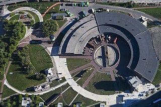
Roundhouse Park is a 17 acre park in the downtown core of Toronto, Ontario, Canada. It is in the former Railway Lands. It features the John Street Roundhouse, a preserved locomotive roundhouse which is home to the Toronto Railway Museum, Steam Whistle Brewing, and the restaurant and entertainment complex The Rec Room. The park is also home to a collection of trains, the former Canadian Pacific Railway Don Station, and the Roundhouse Park Miniature Railway. The park is bounded by Bremner Boulevard, Lower Simcoe Street, Lake Shore Boulevard West/Gardiner Expressway and Rees Street.
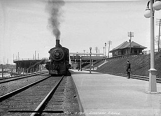
Sunnyside railway station was formerly located at the intersection of King Street, Queen Street West and Roncesvalles Avenue in Toronto, Ontario, Canada. It operated passenger service from 1910 until 1971.

The South Parkdale railway station was a passenger rail station on the Grand Trunk Railway in Toronto, Ontario, Canada. It was located at Jameson Avenue and Springhurst Avenue in the former village of Parkdale. It was demolished in 1911 as part of a grade separation engineering project.

Jameson Avenue is a multi-lane arterial road in the Parkdale neighbourhood in Toronto, Ontario, Canada. It is a north-south roadway from Lake Shore Boulevard to Queen Street. Originally laid out in the 19th century as a two-lane residential street, its traffic and land use has changed considerably from a suburban/semi-rural street to a main arterial connecting to an expressway.

Throughout its history, Toronto has been a city divided into many districts and neighbourhoods. As the city has grown, new neighbourhoods have been created by expansion of the city into the countryside. Over time, the neighbourhoods within existing areas have also been altered and rearranged.
Parkdale—High Park is a provincial electoral district in Toronto, Ontario, Canada, created in 1996 and represented in the Legislative Assembly of Ontario since 1999. It is located in the Toronto's west-end, bordering on the lakefront to the south, the Humber River to the west, and the Canadian Pacific Railway tracks essentially defining its northern and eastern borders. There are 107,035 residents in the district. Federally the electoral district is held by Member of Parliament (MP) Arif Virani, provincially by Member of Provincial Parliament (MPP) Bhutila Karpoche and municipally by city councillor Gord Perks.

Parkdale was a provincial riding electing Members of Provincial Parliament (MPP) to the Legislative Assembly of Ontario. The riding was created from the western part of Toronto West riding in 1914 and abolished in 1996 and redistributed into the Parkdale—High Park, Davenport and Trinity—Spadina ridings for the 1999 Ontario general election.

Parkdale railway station or North Parkdale railway station as it was also known was a passenger train station in Toronto, Ontario, Canada. The station served the Parkdale village on the then-outskirts of Toronto. The station served trains on the Northern Railway of Canada and Credit Valley Railway, later the Canadian Pacific Railway, railways. It was situated at the intersection of Dufferin Street and Queen Street West. The train station was decommissioned in the 1970s.

Via Rail's Toronto Maintenance Centre is a railway yard in the western end of Toronto, which stores and services Via trains. It lies within the south side of the former CN Mimico Yard directly opposite of the Willowbrook Rail Maintenance Facility on the north side; GO Transit's Lakeshore West line separates the two facilities. The yard is bisected by the Islington Avenue flyover bridge. Its main entrance is located at 50 Drummond Street on the eastern side with a secondary entrance on its southern side along New Toronto Street at Eighth Street.