
The Arctic Archipelago, also known as the Canadian Arctic Archipelago, is a group of islands north of the Canadian mainland.

Chelsea is a city in Shelby County, Alabama, United States. It is part of the Birmingham metropolitan area. Chelsea was incorporated on March 1, 1996, with a population of 906. At the 2000 census the population was 2,949. According to the U.S. Census Bureau, the 2010 population for Chelsea was 10,183. Its seasonal campsite for visitors is Hargis Retreat which began in 1984. Chelsea is widely considered the fastest growing city in Shelby County, which is the fastest growing county in the state of Alabama.

Belmont is an unincorporated community and census-designated place (CDP) in Cambria County, Pennsylvania, United States. The population was 2,784 at the 2010 census.

Philipsburg is a borough in Centre County, Pennsylvania, United States. It is located at 40°53′42″N78°13′09″W. It is part of the State College, Pennsylvania Metropolitan Statistical Area. The borough's population was 2,770 at the 2010 census.

Huevos is an island in the Republic of Trinidad and Tobago. The island is 1.01 km² in area. It is one of the "Bocas Islands", which lie in the Bocas del Dragón between Trinidad and Venezuela.

Cotacachi is a canton of Imbabura province of Ecuador in South America. The name also refers to the city which is the seat of that canton, one of Ecuador's leading artisanal manufacturers of leather goods, and to the dormant Cotacachi Volcano which overlooks the canton.

Adrigole, is a village situated on the Beara Peninsula in County Cork, in Ireland. It is centred on the junction of the R572 and R574 regional roads. It has a sparsely distributed population of about 450 people.

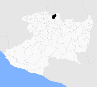
Arandas is a municipality of the Altos Sur region of the state of Jalisco in Mexico. Arandas is also the name of the municipality's main township and the center of the municipal government. It is approximately 2 hours east of Guadalajara.

Pajares de la Lampreana is a municipality located in the province of Zamora, Castile and León, Spain. According to the 2004 census (INE), the municipality has a population of 496 inhabitants.

São Miguel do Anta is a Brazilian municipality located in the state of Minas Gerais. The city belongs to the mesoregion of Zona da Mata and to the microregion of Viçosa.

Costache Negri is a commune in Galați County, Romania with a population of 2,562 people. It is composed of a single village, Costache Negri, and is named after Costache Negri, an 1848 revolutionary.

Brook Glacier is a glacier that flows westward between Mount Strybing, Mount Allen and Krusha Peak on the west side of Owen Ridge in southern Sentinel Range, Ellsworth Mountains in Antarctica, and joins Bender Glacier east of Chaplin Peak. It was named by the Advisory Committee on Antarctic Names (2006) after Edward J. Brook, Professor of Geosciences, Oregon State University; U.S. Antarctic Project investigator of Antarctic paleoclimate in numerous field seasons from 1988; Chair, U.S. National Ice Core Working Group for use of Antarctic ice cores for research purposes, 2004–05.
Arenzana de Abajo is a village in the province and autonomous community of La Rioja, Spain. The municipality covers an area of 8.39 square kilometres (3.24 sq mi) and as of 2011 had a population of 274 people.
Camprovín is a village in the province and autonomous community of La Rioja, Spain. The municipality covers an area of 20.45 square kilometres (7.90 sq mi) and as of 2011 had a population of 178 people.
Ledesma de la Cogolla is a village in the province and autonomous community of La Rioja, Spain. The municipality covers an area of 12.13 square kilometres (4.68 sq mi) and as of 2011 had a population of 22 people.
Tricio is a village in the province and autonomous community of La Rioja, Spain. The municipality covers an area of 6.35 square kilometres (2.45 sq mi) and as of 2011 had a population of 393 people.
Cervellati Glacier is the 5 nmi long glacier situated southeast of Patton Glacier and northwest of Ramorino Glacier on the east slope of Sentinel Range in the Ellsworth Mountains, Antarctica. It flows northeastwards between Tyree Ridge and Epperly Ridge, and enters Crosswell Glacier southeast of Mount Bearskin. The feature was named by US-ACAN in 2006 after Roberto Cervellati, Italian representative to the SCAR Expert Group on Geographic Information, 1992-2006, and director of the SCAR Composite Gazetteer of Antarctica in the same period.
Angamacutiro is a municipality in the Mexican state of Michoacán. It is located in the northern part of the state and its municipal seat is the city of Angamacutiro de la Unión.
The Kungkalenja (Kunkalanya) were an indigenous Australian people of the Channel Country in the state of Queensland.


