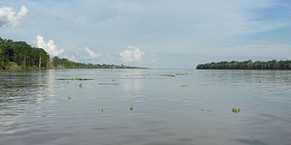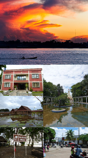
Leticia is the southernmost city in the Republic of Colombia, capital of the department of Amazonas, Colombia's southernmost town and one of the major ports on the Amazon river. It has an elevation of 96 meters above sea level and an average temperature of 27 °C (80.6 °F). Leticia has long been Colombia's shipping point for tropical fish for the aquarium trade. Leticia has approximately 42,000 inhabitants on the left bank of the Amazon river, and is located at the point where Colombia, Brazil and Peru come together in an area called Tres Fronteras.
The Rio Negro is the largest left tributary of the Amazon River, the largest blackwater river in the world, and one of the world's ten largest rivers by average discharge.

The Amazonas Department is a department of Colombia in the south of the country. It is the largest department in area while also having the 3rd smallest population. Its capital is Leticia and its name comes from the Amazon River, which drains the department.

Guainía is a department of Colombia. It is in the east of the country, bordering Venezuela and Brazil. Its capital is Inírida. In 1963 Guainía was split off from Vaupés department. The northern part and the Inírida River are included in the Orinoco basin; the rest is part of the Amazon basin. The Guaviare River is the main area of colonization; many colonos come from the Colombian Andean zone, most of them from Boyacá. They are followed by the llaneros, people from the Eastern plains. The population is mainly composed of Amerindians, and the largest ethnic groups are the Puinaves and the curripacos. There are a total of 24 ethnic groups in the department; many of them speak four Indigenous languages besides Spanish and Portuguese.

Loreto is Peru's northernmost department. Covering almost one-third of Peru's territory, Loreto is by far the nation's largest department; it is also one of the most sparsely populated regions due to its remote location in the Amazon Rainforest. Its capital is Iquitos.

Sucumbíos is a province in northeast Ecuador. The capital and largest city is Nueva Loja. It is the fifth largest province in the country, with an area of 18,084 km². In 2010, it had a population of 176,472 inhabitants.

The Japurá River or Caquetá River is a river about 2,820 kilometres (1,750 mi) long in the Amazon basin. It rises in Colombia and flows eastward through Brazil to join the Amazon River.

The Putumayo River or Içá River is one of the tributaries of the Amazon River, west of and parallel to the Japurá River.

The Cordillera Oriental is the widest of the three branches of the Colombian Andes. The range extends from south to north dividing from the Colombian Massif in Huila Department to Norte de Santander Department where it splits into the Serranía del Perijá and the Cordillera de Mérida in Venezuelan Andes. The highest peak is Ritacuba Blanco at 5,410 m (17,750 ft) in the Sierra Nevada del Cocuy.
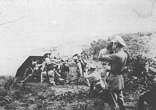
The Leticia Incident, also called the Leticia War or the Colombia–Peru War, was a short-lived armed conflict between Colombia and Peru over territory in the Amazon rainforest. At the end, they reached an agreement for Colombia to stay with a part and Peru with another part.

Amazonía region in southern Colombia comprises the departments of Amazonas, Caquetá, Guainía, Guaviare, Putumayo and Vaupés, and covers an area of 403,000 km², 35% of Colombia's total territory. The region is mostly covered by tropical rainforest, or jungle, which is a part of the massive Amazon rainforest.

Amacayacu National Natural Park is a national park located along the Amazon River in the Amazonas Department in the south of Colombia. The word "Amacayacu" means "River of the Hamocs" in the indigenous language Quechua. The Ticuna people currently inhabit a part of the park.

The slate-colored hawk is a species of bird of prey in the Accipitridae family: the hawks, eagles, and allies.

The violaceous jay is a species of bird in the family Corvidae, the crows and their allies.

Because of its natural structure, Colombia can be divided into six very distinct natural regions. These consist of the Andean Region, covering the three branches of the Andes mountains found in Colombia; the Caribbean Region, covering the area adjacent to the Caribbean Sea; the Pacific Region adjacent to the Pacific Ocean; the Orinoquía Region, part of the Llanos plains mainly in the Orinoco river basin along the border with Venezuela; the Amazon Region, part of the Amazon rainforest; and finally the Insular Region, comprising islands in both the Atlantic and Pacific oceans. Colombia is located in South America.

The border between Brazil and Colombia is 1,644.2 km (1,021.7 mi) long. The boundary was delimited in two treaties:
The Sinchi Amazonic Institute of Scientific Research is a non-profit research institute of the Government of Colombia charged with carrying out scientific investigations on matters relating to the Amazon Rainforest, the Amazon River and the Amazon Region of Colombia for its better understanding and protection. The word sinchi, is a word in Quechua that means "strong" or "fierce".

Chiribiquete National Natural Park is the largest national park in Colombia and the largest tropical rainforest national park in the world. It was established on 21 September 1989 and has been expanded twice, first in August 2013 and then in July 2018. The park occupies about 43,000 km2 (17,000 sq mi) and includes the Serranía de Chiribiquete mountains and the surrounding lowlands, which are covered by tropical moist forests, savannas and rivers.