This article needs additional citations for verification .(February 2024) |

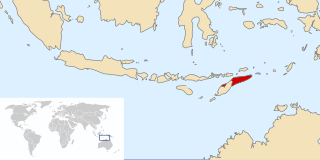
Cailaco is a town in Cailaco Subdistrict in the Bobonaro District of East Timor.
This article needs additional citations for verification .(February 2024) |
Cailaco is a town in Cailaco Subdistrict in the Bobonaro District of East Timor.
East Timor was a province of Indonesia between 1976 and 1999, during the Indonesian occupation of the country. Its territory corresponded to the previous Portuguese Timor and to the present-day independent country of East Timor.

Strandzha Glacier is located on Burgas Peninsula, eastern Livingston Island in the South Shetland Islands, Antarctica northeast of Ropotamo Glacier, south of Sopot Ice Piedmont and southwest of Pautalia Glacier. It is bounded by Delchev Peak to the west, Spartacus Peak, Trigrad Gap and Yavorov Peak to the northwest, and by Elena Peak to the north, extends 1.6 km in northeast–southwest direction and 800 m in northwest–southeast direction, and flows southeastward into Bransfield Strait.
Recta is a district of Bongará Province in Peru.
Nieva District is one of three districts of the province Condorcanqui in Peru.

Belo Monte is a municipality located in the western of the Brazilian state of Alagoas. Its population is 6,710 (2020) and its area is 334 km².
The Lhoosk'uz Dene Nation is the band government of the Lhoosk’uz, a Dakelh people whose main reserve located on the Chilcotin Plateau 130 km west of the city of Quesnel, British Columbia, Canada. The First Nation is a member of the Carrier-Chilcotin Tribal Council, which includes both Tsilhqot'in and Carrier (Dakelh) communities.
Cuchi is a town and municipality in Cuando Cubango Province in Angola. The population of the municipality was 42,974 in 2014.
Paucas District is one of sixteen districts of the Huari Province in Peru.
Lacabamba District is one of eleven districts of the Pallasca Province in Peru.
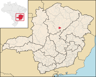
Engenheiro Navarro is a Brazilian municipality located in the north of the state of Minas Gerais. Its population as of 2020 was 7,241 people living in a total area of 632 km2. The city belongs to the mesoregion of North of Minas and to the microregion of Bocaiúva. It became a municipality in 1962.
Telina is an island in Marovo Lagoon, New Georgia Islands in Western Province, in the independent nation of Solomon Islands.
The Broken Group is a group of small islands and islets in the middle of Barkley Sound on the West Coast of Vancouver Island, British Columbia, Canada. It is protected as the Broken Islands Group Unit of the Pacific Rim National Park Reserve, which includes Long Beach, between Ucluelet and Tofino to Barkley Sound's northwest, and the West Coast Trail between Port Renfrew and Bamfield, to the southeast. The group, which lies between Imperial Eagle and Loudon Channels, includes the Brabant Islands and Hand Island, but not Pinkerton Islands. The southernmost of the group is Cree Island; the easternmost is Reeks Island. Benson Island, on the northwest corner of the Broken Group, is an important cultural site for the Tseshaht First Nation.
ISO 28000:2022, Security and resilience – Security management systems – Requirements, is a management system standard published by International Organization for Standardization (ISO) that specifies requirements for a security management system including aspects relevant to the supply chain.
Lamarão is a municipality in the state of Bahia in the North-East region of Brazil.
Villa Las Pirquitas is a village and municipality in Catamarca Province in northwestern Argentina.

Arapya Glacier is the 11.4 kilometres (7.1 mi) long and 5 kilometres (3.1 mi) wide glacier on the east side of north-central Sentinel Range in Ellsworth Mountains, Antarctica, situated south of Young Glacier. It flows southwards along the west side of Barnes Ridge and east of Chapman Peak and joins Ellen Glacier southwest of Mount Besch.

Vnukovo District is an administrative district (raion) of Western Administrative Okrug, and one of the 125 raions of Moscow, Russia. Most of the district is occupied by Vnukovo International Airport, a small adjacent residential area, and a separate residential micro-district. The area of the district is 16.912 square kilometers (6.530 sq mi), and its population was estimated at 20,100 as of 2017.

Kangryong Field(강령흰두루미살이터) is a 1200 ha wetland site in South Hwanghae Province of North Korea. It has been identified by BirdLife International as an Important Bird Area (IBA) because it supports populations of Oriental storks, black-faced spoonbills, Chinese egrets, red-crowned cranes and spoon-billed sandpipers.
Boca do Mato is a region of Rio de Janeiro, but not officially recognized as a neighborhood.

Cailaco, officially Cailaco Administrative Post, is an administrative post in Bobonaro municipality, East Timor. Its seat or administrative centre is in suco Meligo, and its population at the 2004 census was 8,374.
8°54′00″S125°16′48″E / 8.90000°S 125.28000°E
| | This East Timor location article is a stub. You can help Wikipedia by expanding it. |