
A chambered cairn is a burial monument, usually constructed during the Neolithic, consisting of a sizeable chamber around and over which a cairn of stones was constructed. Some chambered cairns are also passage-graves. They are found throughout Britain and Ireland, with the largest number in Scotland.

Kilmartin Glen is an area in Argyll north of Knapdale. It has the most important concentration of Neolithic and Bronze Age remains in mainland Scotland. The glen is located between Oban and Lochgilphead, surrounding the village of Kilmartin. In the village, Kilmartin Museum explains the stories of this ancient landscape and the people who dwelt there. There are more than 800 ancient monuments within a six-mile (ten-kilometre) radius of the village, with 150 monuments being prehistoric. Monuments include standing stones, a henge monument, numerous cists, and a "linear cemetery" comprising five burial cairns. Several of these, as well as many natural rocks, are decorated with cup and ring marks.

New Luce is a civil parish in Dumfries and Galloway, south-west Scotland. It lies in the traditional county of Wigtownshire, and is about 10 miles (16 km) in length and 5 miles (8.0 km) in breath, being the upper part of the original Glenluce Parish. New Luce is shown as a civil parish on John Ainslie's county map of 1782.

The Callanish IV stone circle is one of many megalithic structures around the better-known Calanais I on the west coast of the Isle of Lewis, in the Outer Hebrides, Scotland. It is a scheduled monument and its official name is Sron a'Chail. The site was first surveyed and recorded by RCAHMS in 1914 and again in 2009, with another survey in the 1970s by other archaeologists, but no known archaeological excavations have taken place at the stones.

Kirkcowan is an area about 15 miles in length, and from nearly two to nearly seven miles in breadth, comprising 30,580 acres, of which 7000 are arable, 300 woodland and plantations, and the remainder meadow, pasture in Machars, in the historical county of Wigtownshire, in Dumfries and Galloway, Scotland, with the village of Kirkcowan, bounded on the east by the river Bladnoch, on the west by the river Tarff, and is 6 miles W. by S.W. from Newton Stewart.

Blackhammer Chambered Cairn is a Neolithic chambered cairn located on the island of Rousay, in Orkney, Scotland. The tomb, constructed around 3000 BC, is a Orkney–Cromarty chambered cairn, characterized by stalled burial compartments. Historic Environment Scotland established the site as a scheduled monument in 1994.
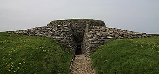
Quoyness chambered cairn is a Neolithic burial monument located on the island of Sanday in Orkney, Scotland. Similar to Maeshowe in design, the tomb was probably built around 3000 BC. The skeletal remains of several people were uncovered in the tomb during excavation in 1867. The monument was partially restored and reconstructed after a second excavation during the early 1950s, to display the different original stages of construction of the tomb. The property is now in the care of Historic Environment Scotland as a scheduled monument.

Machrie Moor Stone Circles is the collective name for six stone circles visible on Machrie Moor near the settlement of Machrie on the Isle of Arran, Scotland.
Old Luce is a civil parish in Dumfries and Galloway, Scotland. It lies in the Machars peninsula, in the traditional county of Wigtownshire. The parish is around 10 miles (16 km) long and 8 miles (13 km) broad, and contains 40,350 acres (16,330 ha).

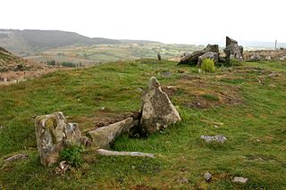
Cairnholy is the site of two Neolithic chambered tombs of the Clyde type. It is located 4 kilometres east of the village of Carsluith in Dumfries and Galloway, Scotland. The tombs are scheduled monuments in the care of Historic Scotland.

Torrylin Cairn is the remains of a Neolithic chambered tomb. It is located near Kilmory on the Isle of Arran in Scotland.
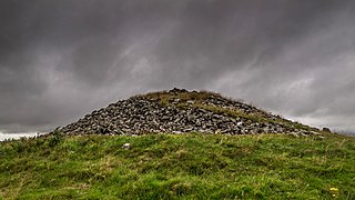
Carn Ban is a Neolithic chambered tomb located on the Isle of Arran in Scotland.
The Giants' Graves are the remains of two Neolithic chambered tombs on the Isle of Arran in Scotland. They are situated within 40 metres of each other, and stand on a ridge 120 metres above the sea in a clearing in a forest, overlooking Whiting Bay to the south.
Lanndale Broch is an Iron Age broch in Sutherland, Scotland.
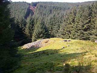
Mid Gleniron is a prehistoric site in Dumfries and Galloway used in the Neolithic and Bronze Age. The site is a scheduled ancient monument that comprises a group of six burial cairns. Two of the cairns, Mid Gleniron I and Mid Gleniron II are chambered cairns of the Clyde tradition. These are of historic importance because of their multi-stage construction which provides evidence for the development of Clyde cairns at the beginning of the Neolithic period.
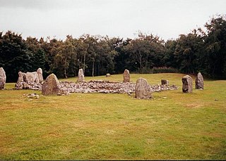
Loanhead of Daviot stone circle is a recumbent stone circle in Aberdeenshire in lowland northeast Scotland. The circle consists of the recumbent stone with its flankers and a complete set of eight orthostats about 21 metres (69 ft) in diameter surrounding a low kerbed ring cairn which has an open court. However, the present appearance has in part been produced by substantial restoration after archaeological excavation in 1934, and in 1989 by the removal of the stones covering the central court.

Huntersquoy chambered cairn is a Neolithic chambered cairn located on the island of Eday, in Orkney, Scotland. The monument dates from the 3rd millennium BC and is an Orkney–Cromarty type chambered cairn. Huntersquoy is a distinctive two-story burial monument with overlapping chambers. Historic Environment Scotland established the site as a scheduled monument in 1936.

Wideford Hill chambered cairn is a Neolithic chambered cairn on Mainland, Orkney in Scotland. The tomb dates to around 2000 BC, and is similar in design to the Maeshowe chambered cairn on Orkney. Historic Environment Scotland established the site as a scheduled monument in 1994.

