The Bay of Palma is a bay located to the south of Palma, Majorca, Spain. It is in the south-west of the Balearic Island of Mallorca. Palma de Majorca's harbour is located on the northern shores along with some famous beaches. It is bounded to the west by Cape Cala Figuera, to the north by the city of Palma, to the south by the Mediterranean Sea and to the east by the White Cape. The Serra de Na Burguesa terminates at its shore.

Banyalbufar is a municipality on the Spanish Balearic island of Majorca. The town of the same name is the administrative seat of the municipality. It borders the municipalities of Estellencs, Puigpunyent, Esporles, and Valldemossa.

Port de Pollença is a small town in northern Majorca, Spain, situated on the Bay of Pollença. It is located about 6 km east of the inland town of Pollença and two kilometres southeast of Cala Sant Vicenç. The Cap de Formentor is connected to Port de Pollença via a 13.5 km road.
Cala Sant Vicenç is a small resort town in north-eastern Majorca, Spain. It consists of three small beaches, plus a few bars and restaurants catering for tourists. Located at one end of the town is the hypogeum of Cala Sant Vicenç, perhaps the most spectacular hypogeum on Mallorca.

Evil Under the Sun is a 1982 British mystery film based on the 1941 novel of the same name by Agatha Christie. It was directed by Guy Hamilton, and stars Peter Ustinov in his second theatrical appearance as the Belgian detective Hercule Poirot.

Cap de Formentor forms the eastern end of Majorca's Formentor peninsula. The Majorcans also call the cape the Meeting point of the winds.

Alaior is a municipality on the island of Menorca, in the Balearic Islands, Spain. It is situated 12 km from the capital, Maó. In 2005 it had a population of 8,671 and it covers an area of 109.77 km².
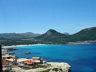
Cala Agulla is a beach in Majorca, Spain.

Cala En Porter is a village in the Alaior municipality of Menorca. It is located on the island's south coast.

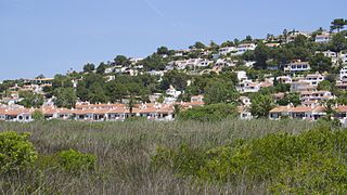
Benissa is a small town in Spain in the province of Alicante, 275 m above sea level, and one of the oldest towns on the Costa Blanca.

Cala d'Or is a village on the east coast of Majorca, in the municipality of Santanyí, Balearic Islands, Spain, consisting of three principal areas: the town centre of Cala d'Or, Cala Egos and Cala Ferrera. It offers many small, fine sandy beaches including Cala Gran, Cala d'Or, Cala Egos, Cala Es Forti, Cala Serena and Cala Esmeralda

Cala Tuent is on Majorca, Spain's largest island, located in the Mediterranean Sea and part of the Balearic Islands archipelago.

Sa Coma is a town on the eastern coast of the island of Majorca, Spain. It is close to the towns of Cala Millor and Cala Bona in the municipality of Sant Llorenç des Cardassar. To the south it merges with the small town of S'illot.
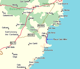
Cala Millor is a tourist destination on the Spanish Balearic Island of Mallorca. It consists of a small bay in the municipalities of Son Servera and Sant Llorenç des Cardassar.

S'illot is a small tourist town on the south east coast of the Balearic Island of Mallorca, Spain, divided between the council areas of Manacor and Sant Llorenç des Cardassar. The two districts are separated by the river Torrent de Ca n'Amer which is spanned by a large bridge in the town. S'Illot is located 63 km east of Palma de Mallorca and 16 km east of Manacor. The little cove of Cala Morlanda and the wide beach of Cala Moreia are situated to the south, while the resort of Sa Coma lies immediately to the north. The nearby small cove of Caló d'en Rafalino, south of Cala Morlanda, has a naturist beach. A range of seaside leisure activities take place in the town. At the entrance to the village there is prehistoric settlement that is well preserved.

Cala Llombards is a beach and resort on the southeast coast of Majorca, located in Santanyí municipality. The village part itself is called Es Llombards. The beach is relatively unknown by tourists and tends to be frequented by local holiday villa owners. The famous Finca Rustica is located in Cala Llombards.

Cala Bona is a small fishing town and holiday resort on the east coast of Majorca in the Balearic Islands of Spain. It consists of a cove with a harbour and surrounding coastal area, and lies within the municipality of Son Servera. The population of the town in 2005 was 1,088 inhabitants. In 2011, it had a population of 1,258. It is located to the north of Cala Millor, to which is connected by a promenade, and it lies to the south of Port Verd. Fodor's 1989 guide to Spain described Cala Bona in these terms: "Once an unspoiled fishing village, but now overwhelmed by neighboring Cala Millor. Mixed rocky and excellent sandy beach."

Cala Xuclar is a beach in the northern part of the Spanish island of Ibiza. It is in the municipality of Sant Joan de Labritja and is 3.8 miles (6.1 km) north of the village of Sant Joan de Labritja, and 1.2 miles (1.9 km) west of the beach resort of Portinatx.

Cala Mitjana is a bay and beach on Menorca's southern coast. The small pine tree surrounded beach can be reached by foot in 20 minutes starting from a parking lot close to country road OM-714. The beach is highly frequented in the summer season.