Look up Calais in Wiktionary, the free dictionary.
Calais is a city in France. The name can also refer to:
Calais is a city in France. The name can also refer to:
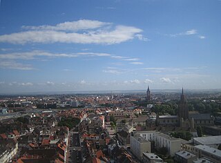
Calais is a French port city in the Pas-de-Calais department, of which it is a subprefecture. Although Calais is by far the largest city in Pas-de-Calais, the department's prefecture is its third-largest city of Arras. The population of the city proper is 67,544; that of the urban area is 144,625 (2020). Calais overlooks the Strait of Dover, the narrowest point in the English Channel, which is only 34 km (21 mi) wide here, and is the closest French town to England. The White Cliffs of Dover can easily be seen on a clear day from Calais. Calais is a major port for ferries between France and England, and since 1994, the Channel Tunnel has linked nearby Coquelles to Folkestone by rail.

Calais is a city in Washington County, Maine, United States. As of the 2020 census, it had a population of 3,079, making Calais the third least-populous city in Maine. The city has three Canada–US border crossings over the St. Croix River connecting to St. Stephen, New Brunswick, Canada.

Boulogne-sur-Mer, often called just Boulogne, is a coastal city in Northern France. It is a sub-prefecture of the department of Pas-de-Calais. Boulogne lies on the Côte d'Opale, a touristic stretch of French coast on the English Channel between Calais and Normandy, and the most visited location in the region after the Lille conurbation. Boulogne is its department's second-largest city after Calais, and the 183rd-largest in France. It is also the country's largest fishing port, specialising in herring.
Liévin is a commune in the Pas-de-Calais department in northern France. The inhabitants are called Liévinois.

St. Stephen is a Canadian town in Charlotte County, New Brunswick, situated on the east bank of the St. Croix River around the intersection of New Brunswick Route 170 and the southern terminus of New Brunswick Route 3. The St. Croix River marks a section of the Canada–United States border, forming a natural border between Calais, Maine and St. Stephen. U.S. Route 1 parallels the St. Croix river for a few miles, and is accessed from St. Stephen by three cross-border bridges.

The St. Croix River is a river in northeastern North America, 71 miles (114 km) in length, that forms part of the Canada–United States border between Maine (U.S.) and New Brunswick (Canada). The river rises in the Chiputneticook Lakes and flows south and southeast, between Calais and St. Stephen. It discharges into Passamaquoddy Bay, in the Bay of Fundy.
Saint-Georges may refer to:

Passamaquoddy Bay is an inlet of the Bay of Fundy, between the U.S. state of Maine and the Canadian province of New Brunswick, at the mouth of the St. Croix River. Most of the bay lies within Canada, with its western shore bounded by Washington County, Maine. The southernmost point is formed by West Quoddy Head on the U.S. mainland in Lubec, Maine; and runs northeasterly through Campobello Island, New Brunswick, engulfing Deer Island, New Brunswick, to the New Brunswick mainland head at L'Etete, New Brunswick in Charlotte County, New Brunswick.
Saint-Michel is the name or part of the name of many places. Michel is French for Michael, and in most cases, these placenames refer to Michael (archangel).

The Maine Central Railroad was a U. S. class 1 railroad in central and southern Maine. It was chartered in 1856 and began operations in 1862. By 1884, Maine Central was the longest railroad in New England. Maine Central had expanded to 1,358 miles (2,185 km) when the United States Railroad Administration assumed control in 1917. The main line extended from South Portland, Maine, east to the Canada–United States border with New Brunswick, and a Mountain Division extended west from Portland to St. Johnsbury, Vermont, and north into Quebec. The main line was double track from South Portland to Royal Junction, where it split into a "lower road" through Brunswick and Augusta and a "back road" through Lewiston, which converged at Waterville into single track to Bangor and points east. Branch lines served the industrial center of Rumford, a resort hotel on Moosehead Lake and coastal communities from Bath to Eastport.
The New Brunswick Southern Railway Company Limited is a 131.7 mi (212.0 km) Canadian short line railway owned by the New Brunswick Railway Company Limited, a holding company that is part of "Irving Transportation Services", a division within the industrial conglomerate J. D. Irving.
Saint-Augustin may refer to:
The East–West Highway is a long-proposed east–west highway corridor in northern New England, intended to link remote northern communities in those states with markets in the Maritimes, Quebec, and upstate New York.

U.S. Route 1 (US 1) in the U.S. state of Maine is a major north–south section of the United States Numbered Highway System, serving the eastern part of the state. It parallels the Atlantic Ocean from New Hampshire north through Portland, Brunswick, and Belfast to Calais, and then the St. Croix River and the rest of the Canada–United States border via Houlton to Fort Kent. The portion along the ocean, known as the Coastal Route, provides a scenic alternate to Interstate 95 (I-95).
Saint-Calais-du-Désert is a commune in the Mayenne department in north-western France.
Remy or Rémy may refer to:
The Calais Branch is a mothballed railroad line in Maine that was operated by the Maine Central Railroad Company (MEC).
Vieil may refer to:

The 2000 United States presidential election in Maine took place on November 7, 2000, and was part of the 2000 United States presidential election. Maine is one of two states in the U.S. that instead of all of the state's four electors of the Electoral College to vote based upon the statewide results of the voters, two of the individual electors vote based on their congressional district because Maine has two congressional districts. The other two electors vote based upon the statewide results.
The International Avenue Bridge is an international bridge across the St. Croix River, connecting the town of St. Stephen, New Brunswick in Canada with the city of Calais, Maine in the United States.