Calca, Peru

Last updated
Calca
Town
Parroquia San Pedro Apostol de Calca, vista.jpg
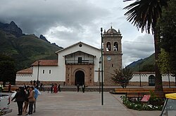
Main square of Calca
Peru location map.svg
Red pog.svg
Calca
Coordinates: 13°19′23″S71°57′22″W / 13.323°S 71.956°W / -13.323; -71.956
CountryFlag of Peru.svg  Peru
Region Cusco
Province Calca
District Calca
Elevation
2,926 m (9,600 ft)
Population
 (2005)
  Total9 732 [1]
Time zone UTC-5 (PET)
The town of Calca and old canal Calca Peru- canal through town and statue.jpg
The town of Calca and old canal

Calca, also referred to as Villa de Zamora, is a town in southern Peru, capital of Calca Province in Cusco Region. It is at an elevation of around 2926 meters (9600 feet) above sea level. [2]

Related Research Articles

<span class="mw-page-title-main">Department of Cuzco</span> Departments of Peru

Cusco, also spelled Cuzco, is a department and region in Peru and is the fourth largest department in the country, after Madre de Dios, Ucayali, and Loreto. It borders the departments of Ucayali on the north; Madre de Dios and Puno on the east; Arequipa on the south; and Apurímac, Ayacucho and Junín on the west. Its capital is Cusco, the historical capital of the Inca Empire.

<span class="mw-page-title-main">Calca Province</span> Province in Cusco, Peru

Calca Province is one of thirteen provinces in the Cusco Region in the southern highlands of Peru. Its seat is Calca.

<span class="mw-page-title-main">Cusco District</span> District in Cusco, Peru

Cusco is a district in the northern Cusco Province within the Cusco Region of Peru. It is bordered by districts of Ccorca and Poroy on the west, the provinces of Anta, the Calca, and Urubamba on the north, the San Jerónimo District on the east, and the districts of Santiago and San Sebastián to the south.

<span class="mw-page-title-main">Calca District</span> District in Cusco, Peru

Calca District is one of eight districts of the province Calca in Peru. The capital of the district is Calca, also known as the capital of the Sacred Valley.

<span class="mw-page-title-main">Coya District</span> District in Cusco, Peru

Coya District is one of eight districts of the Calca Province in the Cusco Region of Peru.

<span class="mw-page-title-main">Lamay District</span> District in Cusco, Peru

Lamay District is one of eight districts of the province Calca in Peru.

<span class="mw-page-title-main">Lares District</span> District in Cusco, Peru

Lares District is one of eight districts of the province Calca in Peru.

<span class="mw-page-title-main">Pisac District</span> District in Cusco, Peru

Pisac District is one of eight districts of the province Calca in Peru.

<span class="mw-page-title-main">San Salvador District</span> District in Cusco, Peru

San Salvador District is one of eight districts of the province Calca in Peru.

<span class="mw-page-title-main">Taray District</span> District in Cusco, Peru

Taray District is one of eight districts of the Calca Province in the Cusco Region in Peru. Its seat is Taray. The town lies near Pisac, southwest of it, at a stream called Pawayuq (Pahuayoc), an affluent of Willkanuta River.

Yanatile District is one of eight districts of the province Calca in Peru.

<span class="mw-page-title-main">Sirihuani</span> Mountain in Peru

Sirihuani or Sirijuani is a 5,359-metre-high (17,582 ft) mountain in the Urubamba mountain range in the Andes of Peru. It is located in the Cusco Region, Calca Province, in the districts of Calca and Lares. It is situated northwest of Sahuasiray and Canchacanchajasa mountains, and northeast of Chicón.

<span class="mw-page-title-main">Chicón</span> Mountain in Peru

Chicón or Chicon is a mountain in the Urubamba mountain range in the Andes of Peru, about 5,530 m (18,140 ft) high. It is located in the Cusco Region, Calca Province, Calca District and in the Urubamba Province, Urubamba District. It is situated northeast of the town of Yucay, southeast of Pumahuanca and southwest of the Sirihuani. The southern part of Chicón is also known as Illahuamán. It belongs to the Yucay District. It reaches a height of 5,060 m (16,601 ft).

<span class="mw-page-title-main">Sahuasiray</span> Mountain in Peru

Sahuasiray, Sawasiray,Colque Cruz or Ccolque Cruz, is one of the highest mountains in the Urubamba mountain range in the Andes of Peru, about 5,818 metres (19,088 ft) high. It lies in the Cusco Region, Calca Province, northwest of Calca. It is situated northeast of Chicón and Canchacanchajasa, southeast of Sirihuani and northwest of Condorhuachana.

Mawk'ataray or Mawk'a Taray is an archaeological site in Peru. It is located in the Cusco Region, Calca Province, Taray District.

Chawaytiri is an archaeological site with rock paintings in Peru. It is situated in the Cusco Region, Calca Province, Pisac District, near the village Chawaytiri. The principal section with paintings predominantly showing llamas is named Llamachayuq Qaqa or Chawaytiri. It lies on the slope of the mountain Muruwiksa (Moro-Wicsa, Morowiqsa, Morro Huicsa). The other sections are named Wamanwachana, Kawituyuq (Cahuituyoc), P'allqapata (Pallcapata), Musuqllaqta (Mosoqllaqta), Misaqaqa and Qaqa.

Llamayuq is an archaeological site with tombs and rock paintings in Peru. It is situated in the Cusco Region, Calca Province, Calca District. The site lies at a height of about 4,000 metres (13,123 ft) on the slope of Llamayuq Q'asa, also known as Qucha Quyllur, in a valley called Wakan Wayq'u (Waqhanhuayq’o).

Pukaqucha may refer to:

Yana Urqu or Yana Urku may refer to:

Qusqu Qhawarina may refer to:

References

  1. "World Gazetteer: Calca - profile of geographical entity including name variants". Archived from the original on 2013-04-28. Retrieved 2020-03-26.
  2. "Provincias y Distritos | en Peru" . Retrieved 2020-03-25.