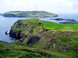
Calf Sound (Manx : Yn Cheyllys) is a body of water which separates the Calf of Man island from the mainland of the Isle of Man. [1] The sound - technically a strait - is about 700 yards in width, and contains the small islet of Kitterland, which is home to a large colony of seals. [1]
The name 'calf' comes from the Old Norse word 'kalfr', which means a small island close to a larger one. [2]
A Cafe overlooking the Calf of Man offers both indoor and outdoor seating (2024). [3] The original building erected to house a visitor centre was designed to have little visual impact when looking towards the Calf of Man, partially achieved by covering the roof with turf. Today a modern building with glass walls offers views of the scenery.[ citation needed ]
There is car parking available. The bus service from Port Erin ceased in 2024.
The Isle of Man or Mann, is a self-governing British Crown Dependency in the Irish Sea, between Great Britain and Ireland. It is one of the Celtic nations and is the homeland of the Manx people, a Celtic ethnic group. As head of state, Charles III holds the title Lord of Mann and is represented by a Lieutenant Governor. The government of the United Kingdom is responsible for the Isle of Man's military defence and represents it abroad, but the Isle of Man still has a separate international identity.
The Isle of Man is an island in the Irish Sea, between Great Britain and Ireland in Northern Europe, with a population of almost 85,000. It is a British Crown dependency. It has a small islet, the Calf of Man, to its south. It is located at 54°15′N4°30′W.
Manx, also known as Manx Gaelic, is a Gaelic language of the insular Celtic branch of the Celtic language family, itself a branch of the Indo-European language family. Manx is the heritage language of the Manx people.
Calf of Man is a 2.50-square-kilometre (618-acre) island, off the southwest coast of the Isle of Man. It is separated from the Isle of Man by a narrow stretch of water called the Calf Sound.
The House of Keys is the directly elected lower house of Tynwald, the parliament of the Isle of Man, the other branch being the Legislative Council.
The Calf of Eday is an uninhabited island in Orkney, Scotland, lying north east of Eday. It is known for its wildlife and its prehistoric ruins.
Manx National Heritage is the national heritage organisation for the Isle of Man. The organisation manages a significant proportion of the Island’s physical heritage assets including over 3,000 acres of coastline and landscape. It holds property, archives, artwork, library and museum collections in trust for the Manx nation. It is the Isle of Man's statutory heritage agency and an Isle of Man registered charity (№ 603).
Kitterland is an islet in the Calf Sound between the Isle of Man and the Calf of Man in the Irish Sea.
Garff is one of the six sheadings of the Isle of Man.
The Level is a seasonally operated request stop on the Isle of Man Railway located in the sheading of Rushen on the Isle of Man. This is the sole remaining section of the railway which once spanned over 46 miles with lines to Peel in the west, Ramsey in the north and the mining village of Foxdale in the centre of the island.
Cava is an uninhabited island in the Orkney archipelago in Scotland. It is 107 hectares (0.41 sq mi) in extent and rises to 38 metres (125 ft) above sea level. The literal meaning of the name is calf island, a terminology often used to designate a small island near to a larger one. Cava is unusual in that it includes a small peninsula joined to the main body of the island by a narrow isthmus, which is in turn called Calf of Cava.
One of the characteristics of the Isle of Man Railway is the numerous level crossings and farm crossings along the various routes; many smaller crossing places are marked only by gates that criss-cross farm land and provide access to private roads connecting the farms to the main roads. Being largely rural in nature the railway has many of these scattered along the existing South Line, and there were many more on the closed sections of the railway. These can be summarised as follows, along with other points of interest along the line not covered in the Isle of Man Railway stations section:-
The Bungalow, Isle of Man, one of a handful of better-known vantage points spread around the Snaefell Mountain Course, is situated adjacent to the 31st Milestone roadside marker on the road junction of the primary A18 Mountain Road, the A14 Sulby Glen Road and the road-tramway crossing for the Snaefell Mountain Railway in the parish of Lezayre in the Isle of Man.
Ballaragh Halt is an intermediate stopping place on the northerly section of the Manx Electric Railway on the Isle of Man.
Quarterbridge is situated soon after the 1 mile-marker measured from the TT Grandstand, part of the Snaefell Mountain Course used for the Isle of Man TT races, at the junction of the primary A1 Douglas to Peel road, A2 Douglas to Ramsey road and the A5 Douglas to Port Erin road which forms the boundary between the parishes of Braddan and Onchan in the Isle of Man.
Niarbyl is a rocky promontory on the southwest coast of the Isle of Man between Port Erin and Peel. It is best known for its spectacular sea views which include the Calf of Man and, on clear days, the mountains of Ireland.
Barrow House is a late 18th-century mansion situated on the eastern shore of Derwentwater in Borrowdale within the Lake District National Park, in the county of Cumbria, England. The house is a Grade II listed building which since the time of its construction has had various uses: it was originally a private dwelling and has since served as a hotel, a youth hostel run by the YHA, and was then an independent hostel until March 2024.
The Manx Museum in Douglas, Isle of Man is the national museum of the Isle of Man. It is run by Manx National Heritage. The museum covers 10,000 years the history of the Isle of Man from the Stone Age to the modern era.
54°03′39″N4°47′56″W / 54.06083°N 4.79889°W