Related Research Articles

The Arctic Archipelago, also known as the Canadian Arctic Archipelago, is an archipelago lying to the north of the Canadian continental mainland, excluding Greenland and Iceland.

Fort Deposit is a town in Lowndes County, Alabama, United States. Since 1890, it has been the largest town in Lowndes County. At the 2010 census the population was 1,344, up from 1,270 in 2000. It is part of the Montgomery Metropolitan Statistical Area.

Calico Rock is a city in Izard County, Arkansas, United States. The population was 1,545 at the 2010 census, up from 991 in 2000.

Selby-on-the-Bay is a census-designated place (CDP) in Anne Arundel County, Maryland, United States, for the 2000 census, at which time its population was 3,674. It was added to the Mayo CDP for the 2010 census.

Baffin Bay, located between Baffin Island and the west coast of Greenland, is defined by the International Hydrographic Organization as a marginal sea of the Arctic Ocean. It is sometimes considered a sea of the North Atlantic Ocean. It is connected to the Atlantic via Davis Strait and the Labrador Sea. The narrower Nares Strait connects Baffin Bay with the Arctic Ocean. The bay is not navigable most of the year because of the ice cover and high density of floating ice and icebergs in the open areas. However, a polynya of about 80,000 km2 (31,000 sq mi), known as the North Water, opens in summer on the north near Smith Sound. Most of the aquatic life of the bay is concentrated near that region.

The Second Happy Time was a phase in the Battle of the Atlantic during which Axis submarines attacked merchant shipping and Allied naval vessels along the east coast of North America. The First Happy Time was in 1940–1941 in the North Atlantic and North Sea. Adolf Hitler and Benito Mussolini declared war on the United States on 11 December 1941, and as a result their navies could begin the Second Happy Time.

Daggett is an unincorporated community located in San Bernardino County, California in the United States. The town is located on Interstate 40 ten miles (16 km) east of Barstow. The town has a population of about 200. The ZIP code is 92327 and the community is inside area code 760.

Cape Lookout is the southern point of the Core Banks, one of the natural barrier islands on the Atlantic coast of North Carolina. It delimits Onslow Bay to the west from Raleigh Bay to the east. Core Banks and Shackleford Banks have been designated as parts of the Cape Lookout National Seashore.
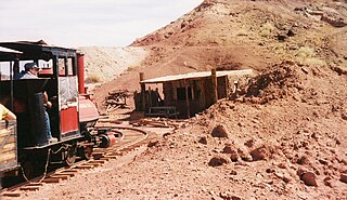
The Calico & Odessa Railroad is a 2 ft 6 in narrow gauge heritage railroad in the ghost town of Calico, California, headquartered in Yermo, California. It was named for the town and mountain range of Calico and the nearby Odessa Canyon.

The Calico Mountains of California are a mountain range located in the Mojave Desert. The range spans San Bernardino and Inyo counties in California.

Little Muncy Creek is the major tributary of Muncy Creek in Lycoming and Sullivan Counties, Pennsylvania, United States. Via Muncy Creek and the West Branch Susquehanna River, it is part of the Susquehanna River drainage basin and waters from it flow ultimately into the Chesapeake Bay.
Barden Inlet is the southernmost of the Outer Banks water inlets. Located just northwest of Cape Lookout in the U.S. state of North Carolina, the inlet connects Onslow Bay of the Atlantic Ocean with Core Sound. It separates the Shackleford Banks from the Core Banks.
The Back Sound is a lagoon in eastern North Carolina. Running on an east–west axis, the sound separates Shackleford Banks to the south from the mainland and Harkers Island to the north. At the sound's eastern end lies Cape Lookout and Core Sound, while on the west end lies the Crystal Coast community of Beaufort and Bogue Sound. Barden Inlet at the eastern end, and Beaufort Inlet on the western end connect the sound to Onslow Bay. Much of the islands in the sound are protected as part of the Rachel Carson Estuarine Reserve, set aside for the protection of Banker horses.

Curtis Creek is a tidal creek located in Baltimore City and Anne Arundel County, Maryland. It is a tributary of the cove Curtis Bay and is adjacent to the west of the South Baltimore community of Curtis Bay. The creek begins at the confluence of Furnace Creek and Marley Creek in northern Anne Arundel County, Maryland and flows north about 2.5 miles (4.0 km) into Curtis Bay which opens to the east into the main branch and stem of the Patapsco River and Chesapeake Bay.

Bluie was the United States military code name for Greenland during World War II. It is remembered by the numbered sequence of base locations identified by the 1941 United States Coast Guard South Greenland Survey Expedition, and subsequently used in radio communications by airmen unfamiliar with pronunciation of the Greenlandic Inuit and Danish names of those locations. These were typically spoken BLUIE (direction) (number), with direction being east or west along the Greenland coast from Cape Farewell.
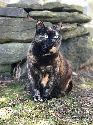
Tortoiseshell is a cat coat coloring named for its similarity to tortoiseshell pattern. Like tortoiseshell-and-white or calico cats, tortoiseshell cats are almost exclusively female. Male tortoiseshells are rare and are usually sterile.
Calico National Recreation Trail, also known as the Upper Calico Trail, is located in the Dolores Ranger District of San Juan National Forest, the 5.5 mile Upper Calico Trail is rated moderate/difficult and has a starting elevation of 10,150' and an ending elevation of 10,400'.

Hepatus epheliticus, known by various names, including the calico crab and Dolly Varden crab, is a species of crab. It lives in shallow water in the western Atlantic Ocean from the Chesapeake Bay to the Dominican Republic. It has a 3-inch (76 mm)–wide carapace adorned with large red spots with darker outlines.
Calico Valley is a valley in Bartow County, in the U.S. state of Georgia. The valley contains Calico Creek which emerges from a spring in the valley and runs through the base until it joins the larger Pinelog Creek.
References
- ↑ U.S. Geological Survey Geographic Names Information System: Calico Bay
- ↑ Proffitt, Martie (Apr 17, 1983). "Local history offers tasty tidbits". Star-News. pp. 8C. Retrieved 1 November 2015.
34°43′51″N76°42′44″W / 34.7307168°N 76.7121541°W