Related Research Articles

Bartow County is located in the northwestern part of the U.S. state of Georgia. As of the 2020 census, the population was 108,901, up from 100,157 in 2010. The county seat is Cartersville.
Euharlee is a city in Bartow County, Georgia, United States. The population was 4,136 at the 2010 census, an increase of 29% over the 2000 count of 3,208.

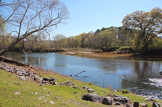
The Etowah River is a 164-mile-long (264 km) waterway that rises northwest of Dahlonega, Georgia, north of Atlanta. On Matthew Carey's 1795 map the river was labeled "High Town River". On later maps, such as the 1839 Cass County map, it was referred to as "Hightower River", a name that was used in most early Cherokee records.
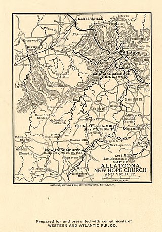
Allatoona is an unincorporated community in Bartow County, in the U.S. state of Georgia. The community is located along Allatoona Creek, 6 miles (9.7 km) southeast of Cartersville. It was once a small mining community until a dam was erected at the base of the Etowah River, completely flooding the town of Allatoona. It is today perhaps best known as the site of the Battle of Allatoona.

Macedonia is an unincorporated community along Georgia Highway 20 in eastern Cherokee County, Georgia, United States approximately six miles east of the county seat, Canton. The center of Macedonia is approximately 45 miles north of Atlanta via I-75 / I-575 or 35 miles via Georgia 400. Straight-line distance indicates mileage of 31 miles from the center of downtown Atlanta.

Atco is a small unincorporated community on the northwestern side of Cartersville in southern Bartow County, Georgia, United States. There are numerous baseball and soccer complexes in the area, primarily along Sugar Valley and Cassville Roads, making it a popular destination for subdivisions. The community derived its name from the American Textile Company, which built a mill in the community.

George Washington Carver State Park was a state park in the U.S. state of Georgia. It existed from 1950 to 1975, when it was then leased to Bartow County as a county park known as Bartow Carver Park, and since 2017 as George Washington Carver Park. Red Top Mountain, located on Lake Allatoona, consists of 1,553 acres (6 km2) and derives its name from the rich red color of the soil that comes from the high iron content in the ground. In 1950, the state initially leased the land for 25 years from the U.S. Army Corps of Engineers. The park served not only to preserve the area's history, but also boost Bartow County's growth and agricultural economy.
Salacoa Creek is a stream in Bartow County, in northwestern Georgia, United States, that is a tributary of the Coosawattee River. Its own tributaries include the Pine Log Creek.
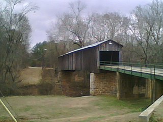
Euharlee Creek is a 21-mile-long (35 km) waterway which traverses across two counties in Georgia, USA, Bartow County and Polk County. It begins in Polk County near the city of Rockmart and joins the Etowah River in Euharlee. The historic Euharlee Covered Bridge spans Euharlee Creek.

Nancy Creek is a stream near Cartersville in Bartow County, Georgia, United States.

Bolivar is an unincorporated community in Bartow County, in the U.S. state of Georgia.

Connesena Creek is a stream in Bartow County, in the U.S. state of Georgia. It is a tributary to the Etowah River.

Corbin is an unincorporated community in Bartow County, in the U.S. state of Georgia.
Oothkalooga Creek is a stream in the U.S. state of Georgia. It is a tributary to the Oostanaula River.

Folsom is an unincorporated community in Bartow County, in the U.S. state of Georgia.

Pettit Creek is a stream in Bartow County, Georgia.
Pumpkinvine Creek is a stream in the U.S. state of Georgia. It is a tributary of the Etowah River.
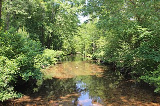
Stamp Creek is a stream in the U.S. state of Georgia. It empties into Lake Allatoona.
The Bartow County Library System (BCLS) is the public library system of Bartow County, Georgia, United States. It consists of three branches serving a population of 103,000 people. The main branch is located in Cartersville, while supplementary branches are present in Adairsville and Euharlee.

Ford is an extinct town in Bartow County, in the U.S. state of Georgia.
References
- ↑ U.S. Geological Survey Geographic Names Information System: Calico Valley
- ↑ "Bartow County". Calhoun Times. September 1, 2004. p. 15. Retrieved 23 April 2015.
34°22′36.3″N84°44′19.8″W / 34.376750°N 84.738833°W
| | This Bartow County, Georgia state location article is a stub. You can help Wikipedia by expanding it. |