Related Research Articles

Sacramento is the capital city of the U.S. state of California and the seat of Sacramento County. Located at the confluence of the Sacramento and American Rivers in Northern California's Sacramento Valley, Sacramento's 2020 population of 524,943 makes it the fourth-most populous city in Northern California, the sixth-most populous in the state, the ninth-most populous state capital,and the 35th most populous in the United States. Sacramento is the seat of the California Legislature and the governor of California. Sacramento is also the cultural and economic core of the Greater Sacramento area, which at the 2020 census had a population of 2,680,831, the fourth-largest metropolitan area in California.

Sacramento County is a county located in the U.S. state of California. As of the 2020 census, the population was 1,585,055. Its county seat is Sacramento, which has been the state capital of California since 1854.

The Central Valley is a broad, elongated, flat valley that dominates the interior of California. It is 40–60 mi (60–100 km) wide and runs approximately 450 mi (720 km) from north-northwest to south-southeast, inland from and parallel to the Pacific coast of the state. It covers approximately 18,000 sq mi (47,000 km2), about 11% of California's land area. The valley is bounded by the Coast Ranges to the west and the Sierra Nevada to the east.

California State University, Sacramento is a public university in Sacramento, California. Founded in 1947 as Sacramento State College, it is part of the California State University system.
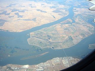
Delta Meadows River Park (DMRP) is a state park property of California, United States, preserving an undeveloped piece of the Sacramento–San Joaquin River Delta. At present it is open to the public for walking, fishing and boating but has no visitor services. The park encompasses sloughs, wet meadows, and an island between the Sacramento and Mokelumne Rivers. It is located near the historic Chinese American town of Locke, 28 miles (45 km) equidistant from Sacramento and Stockton. The 472-acre (191 ha) property was established in 1985.
Marjie Lundstrom is an American journalist. She received the Pulitzer Prize for National Reporting in 1991. Lundstrom has worked for The Fort Collins Coloradoan, the Denver Monthly, and The Denver Post. She was a reporter and senior writer for The Sacramento Bee. Currently, she is the deputy editor for two nonprofit publications, FairWarning, located in Pasadena, CA, and CalMatters, based in Sacramento.
Sutter Health is a not-for-profit integrated health delivery system headquartered in Sacramento, California. It operates 24 acute care hospitals and over 200 clinics in Northern California.

California Proposition 7, would have required California utilities to procure half of their power from renewable resources by 2025. In order to make that goal, levels of production of solar, wind and other renewable energy resources would more than quadruple from their current output of 10.9%. It would also require California utilities to increase their purchase of electricity generated from renewable resources by 2% annually to meet Renewable Portfolio Standard (RPS) requirements of 40% in 2020 and 50% in 2025. Current law AB32 requires an RPS of 20% by 2010.
The Sacramento State Hornets is the team that represents California State University, Sacramento in intercollegiate athletics.

The 2018 California Superintendent of Public Instruction primary election was held on June 5, 2018, to elect the Superintendent of Public Instruction of California. Unlike most other elections in California, the superintendent is not elected under the state's "top-two primary". Instead, the officially nonpartisan position is elected via a general election, with a runoff held on November 6, 2018, because no candidate received a majority of the vote.

Hammond Island is a small island in Suisun Bay, California. It is part of Solano County. Its coordinates are 38°06′18″N121°56′15″W. An 1850 survey map of the San Francisco Bay area made by Cadwalader Ringgold shows islands partially covering some of the current area of Hammond Island, labeled "Davis Island" and "Warrington Island".

Simmons Island is a small island in Grizzly Bay in the San Francisco Bay Area of California. It is part of Solano County, and included within Reclamation District 2127. Its coordinates are 38°05′49″N121°59′26″W. It is shown as "Simmons Island" on an 1850 survey map of the San Francisco Bay area made by Cadwalader Ringgold, and as "Simons Island" on an 1854 map of the area by Henry Lange. It is labeled, along with Deadman Island, Joice Island, Grizzly Island, Ryer Island and Roe Island, on a 1902 USGS map of the area.
West Island is a small island in the San Joaquin River, California. It is part of Sacramento County. Its coordinates are 38°01′24″N121°46′43″W. It is shown, labeled "Webers Island", on an 1850 survey map of the San Francisco Bay area made by Cadwalader Ringgold and an 1854 map of the area by Henry Lange.

Decker Island is a small island in the Sacramento-San Joaquin River delta, in California. It is part of Solano County. Its coordinates are 38.0904745°N 121.7191214°W. Part of the island is the Decker Island Wildlife Area, operated by the California Department of Fish and Wildlife.

Atherton Island is a small island in the Sacramento–San Joaquin River Delta. It is in unincorporated San Joaquin County, California, part of Stockton. Its coordinates are 37°57′22″N121°21′01″W, and the United States Geological Survey measured its elevation as 13 ft (4.0 m) in 1999. It appears on a 2015 USGS map of the area.

Ida Island is a small island in the Sacramento–San Joaquin River Delta. It is part of Sacramento County, California. Its coordinates are 38°10′14″N121°38′12″W, and the United States Geological Survey measured its elevation as 3 ft (0.91 m) in 1981. It appears on a 1978 USGS map of the area.

Hog Island is an island in the San Joaquin River, and is one of many islands which constitute the Sacramento–San Joaquin River Delta. It was used for agriculture in the early 20th century, but has now mostly become marsh or submerged land; it remains a spot for fishing, particularly channel and blue catfish.

Middle Ground Island is an island in Suisun Bay, an embayment of San Francisco Bay, downstream of the Sacramento–San Joaquin River Delta. It is part of Solano County, California, and not managed by any reclamation district. Its coordinates are 38°03′46″N121°58′53″W, and the United States Geological Survey measured its elevation as 0 ft (0 m) in 1981.

Montezuma Island is an island in Suisun Bay, an embayment of San Francisco Bay, and downstream of the Sacramento–San Joaquin River Delta. It is part of Sacramento County, California, and not managed by any reclamation district. Its coordinates are 38°04′28″N121°50′23″W, and the United States Geological Survey measured its elevation as 7 ft (2.1 m) in 1981. It is labeled "Burnett Island" on an 1850 survey map of the San Francisco Bay area made by Cadwalader Ringgold, and shown (unlabeled) on an 1854 map of the area by Henry Lange.
References
- ↑ Michael Taylor, "New Plea to Lift Prison Media Ban," San Francisco Chronicle, December 30, 1995, page 13
- ↑ Erica Werner, San Antonio Express-News, September 25, 2003, page 13
- ↑ Brad Hayward, The Sacramento Bee, July 20, 1997, page 3
- ↑ "Association website". Archived from the original on 2011-09-13. Retrieved 2011-09-18.
This article about an organization in the United States is a stub. You can help Wikipedia by expanding it. |