Route 47 is a state highway in the southern part of New Jersey. It runs 75.20 mi (121.02 km) from Atlantic Avenue in Wildwood, Cape May County, north to U.S. Route 130 in Brooklawn, Camden County. It is also referred to as Delsea Drive, as it connects the Delaware River near Brooklawn to the Atlantic Ocean in Wildwood. This name was assigned by the New Jersey Legislature in 1933. The route runs through rural areas of Cape May and southern Cumberland counties as a two-lane road. Traffic jams along this portion of Route 47 are commonplace in the summer vacation season and can stretch for miles due to the missing southern section of Route 55, where all Jersey Shore-bound traffic enters the small two-lane road. North of here, the route runs through the cities of Millville and Vineland before entering Gloucester County, where it passes through more rural areas as well as Clayton and Glassboro. Past Glassboro, it heads through suburban areas in Washington and Deptford townships before running through Westville and Brooklawn. Route 47 is the longest signed state route in New Jersey.

Wilshire Boulevard (['wɪɫ.ʃɚ]) is a prominent 15.83 mi (25.48 km) boulevard in the Los Angeles area of Southern California, extending from Ocean Avenue in the city of Santa Monica east to Grand Avenue in the Financial District of downtown Los Angeles. One of the principal east–west arterial roads of Los Angeles, it is also one of the major city streets through the city of Beverly Hills. Wilshire Boulevard runs roughly parallel to Santa Monica Boulevard from Santa Monica to the west boundary of Beverly Hills. From the east boundary, it runs a block south of Sixth Street to its terminus.

Interstate 565 (I-565) is a 22-mile-long (35 km) Interstate spur that connects I-65 in Decatur with U.S. Route 72 (US 72) in Huntsville in the US state of Alabama.

The Huntsville–Decatur–Albertville, Alabama, combined statistical area is the most populated sub-region of North Alabama, and is the second largest combined statistical area in the State of Alabama after Birmingham. The Huntsville-Decatur-Albertville CSA had a total of 879,315 people in 2022 and ranks 68th in the country.

New York State Route 61 (NY 61) is a state highway located almost entirely in the city of Niagara Falls in Niagara County, New York, in the United States. The road runs across the city in a northwest–southeast direction, terminating at NY 384 at its southern extent and NY 104 at its northern tip. Conceptually, the road, known as Hyde Park Boulevard, forms the eastern border of downtown Niagara Falls. It is the second-shortest two-digit route in New York after NY 71 in Columbia County. The NY 61 designation was in 1958 after being approved by the Niagara Falls City Council.

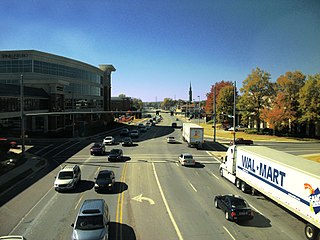
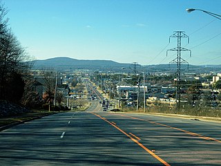
Memorial Parkway, also known as the Parkway, is a major thoroughfare in Huntsville, Alabama that carries over 100,000 vehicles on average a day. It, in whole or in part, follows U.S. Route 231, U.S. Route 431, U.S. Route 72, and State Route 53 through the Huntsville city limits. It is a limited access road through most of Huntsville city proper, providing exits to the frontage road which allows access to road intersections, as well as businesses and residences along the route. Both the limited access and frontage roads are referred to as Memorial Parkway. Originally constructed to bypass downtown Huntsville and officially opened on December 1, 1955, the highway is the major commercial thoroughfare through Huntsville, a status it has held since the mid-1960s.

Pennsylvania Route 232 (PA 232) is a 25.2-mile-long (40.6 km) state highway located in southeastern Pennsylvania. The southern terminus of the route is at U.S. Route 1 (US 1)/US 13 at the Oxford Circle in Philadelphia. The northern terminus is at PA 32 in the borough of New Hope, Bucks County, on the banks of the Delaware River. The route passes through the urban areas of Northeast Philadelphia as Oxford Avenue, serving the Lawncrest, Burholme, and Fox Chase neighborhoods. Upon entering Montgomery County, PA 232 becomes Huntingdon Pike and through suburban areas, serving the communities of Rockledge, Huntingdon Valley, and Bryn Athyn. The route passes through more suburban development in Bucks County as Second Street Pike, running through Southampton and Richboro. In Wrightstown Township, PA 232 enters rural areas and becomes Windy Bush Road as it heads north to New Hope.

State Route 309 is a primary state highway in the U.S. state of Virginia. Known for most of its length as Old Dominion Drive, which was once the right of way of the Great Falls Division of the Washington and Old Dominion Railroad, the state highway runs 5.33 miles (8.58 km) from SR 123 in McLean east to U.S. Route 29 in Arlington.
The Orbit fixed-route bus system began in 1990 in response to the growing population and congestion of the city of Huntsville, Alabama. The system is run by the city of Huntsville, and is funded by city and federal funds.

U.S. Route 220 is a north–south U.S. highway which travels from Rockingham, North Carolina, to South Waverly, Pennsylvania. In the U.S. state of North Carolina, US 220 travels 123.4 miles (198.6 km) from an intersection with US 1 in Rockingham to the Virginia state line near Price, North Carolina. The highway is an important north–south route in Central North Carolina, connecting Rockingham, Asheboro, Greensboro, and Summerfield. US 220 runs concurrently with Interstate 73 from north of Rockingham to Greensboro, and from Summerfield to Stokesdale; while US 220 runs concurrently with I-74 from Rockingham to Randleman.

Governors Drive is a major east–west thoroughfare in Huntsville, Alabama. It follows U.S. Route 431 (US-431) in east Huntsville and State Route 53 (SR-53) in west Huntsville. Governors Drive is one of the main entrance points to the city from the east, carrying on average approximately 48,000 vehicles a day across Monte Sano Mountain.

University Drive is a major east–west thoroughfare in Huntsville, Alabama, following US Route 72 into the city from the west. The highway carries on average approximately 56,000 vehicles a day at 45 mph (72 km/h).

Airport Road is a major east–west thoroughfare in Huntsville, Alabama that connects the Jones Valley and Hampton Cove subdivisions to Memorial Parkway and the rest of the city. On average approximately 32,000 vehicles travel the 2-mile stretch of road a day.

An extensive collection of parks and greenways exists in Huntsville, Alabama for the public's recreational use.
Bob Wallace Avenue and Sparkman Drive are major thoroughfares in Huntsville, Alabama that connect to make a horseshoe-shaped road around the city. The two roads run through several residential neighborhoods and school zones including the University of Alabama in Huntsville. On average, approximately 21,000 vehicles travel along the roads each day.
Monte Sano Nature Preserve is, at 1,107 acres (448 ha), one of the largest urban nature preserves in the US and is located on Monte Sano Mountain in Huntsville, Alabama. The Land Trust of North Alabama manages the nature preserve and Land Trust volunteers have created 23+ miles of public trails. Residents and visitors alike enjoy the multi-use trails for hiking, biking, running, bird watching, environmental education, and general recreation. The trail system was honored in 2011 by the Department of the Interior as National Recreation Trails making them the first NRT trails in Madison County.
Denny Way is an east–west arterial street in downtown Seattle, Washington, United States. It forms the northern end of the Belltown street grid as well as the boundaries of Belltown, Lower Queen Anne, South Lake Union, Denny Triangle, and Cascade. The street continues east through Capitol Hill to Madrona as a minor neighborhood street, ending near Madrona Park on Lake Washington.
Ridge Pike is a major historic road in the U.S. state of Pennsylvania that opened in 1706 that originally connected Wissahickon Creek to Perkiomen Creek. Inside Philadelphia, it is called Ridge Avenue. Going westward, it traverses many eastern Pennsylvania neighborhoods in Montgomery County including Conshohocken and beyond, connecting with Germantown Pike near Collegeville and continuing to Pottstown. In Montgomery County, Ridge Pike is called Main Street in the Norristown area and again in Collegeville and Trappe, and is called High Street in the Pottstown area.


