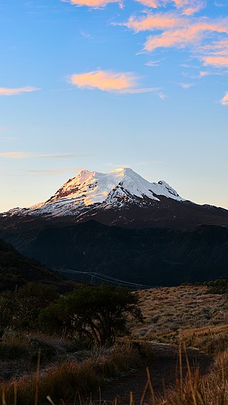
Calinga is a mountain in the Andes of Argentina. It has a height of 6028 metres.
Calinga is a mountain in the Andes of Argentina. It has a height of 6028 metres.
| | This article about a place in La Rioja Province, Argentina is a stub. You can help Wikipedia by expanding it. |

The Andes, Andes Mountains or Andean Mountain Range are the longest continental mountain range in the world, forming a continuous highland along the western edge of South America. The range is 8,900 km (5,530 mi) long and 200 to 700 km wide and has an average height of about 4,000 m (13,123 ft). The Andes extend from South to North through seven South American countries: Argentina, Chile, Bolivia, Peru, Ecuador, Colombia, and Venezuela.

A mountain range or hill range is a series of mountains or hills arranged in a line and connected by high ground. A mountain system or mountain belt is a group of mountain ranges with similarity in form, structure, and alignment that have arisen from the same cause, usually an orogeny. Mountain ranges are formed by a variety of geological processes, but most of the significant ones on Earth are the result of plate tectonics. Mountain ranges are also found on many planetary mass objects in the Solar System and are likely a feature of most terrestrial planets.

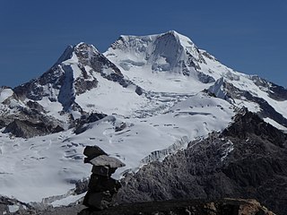
Chimborazo is a stratovolcano situated in Ecuador in the Cordillera Occidental range of the Andes. Its last known eruption is believed to have occurred around 550 A.D. Although not the tallest mountain in the Andes or on Earth relative to sea level, its summit is the farthest point on Earth's surface from the Earth's center due to its location along the planet's equatorial bulge. Chimborazo's height from sea level is 6,263 m (20,548 ft), well below that of Mount Everest at 8,849 m.

Uruguayan Air Force Flight 571 was the chartered flight of a Fairchild FH-227D from Montevideo, Uruguay, to Santiago, Chile, that crashed in the Andes mountains in Argentina on 13 October 1972. The accident and subsequent survival became known as the Andes flight disaster and the Miracle of the Andes.
A cordillera is a small chain and/or network system of mountain ranges, such as those in the west coast of the Americas. The term is borrowed from Spanish, where the word comes from cordilla, a diminutive of cuerda ('rope').
Antisana is a stratovolcano of the northern Andes, in Ecuador. It is the fourth highest volcano in Ecuador, at 5,753 metres (18,875 ft), and is located 50 kilometres (31 mi) SE of the capital city of Quito.

Tupungato, one of the highest mountains in the Americas, is a massive Andean lava dome dating to Pleistocene times. It lies on the Argentina–Chile border, between the Chilean Metropolitan Region and the Argentine province of Mendoza, about 100 km (62 mi) south of Aconcagua, the highest peak of both the Southern and Western hemispheres. Immediately to its southwest is the active Tupungatito volcano, which last erupted in 1987.

The Cordillera Oriental is the widest of the three branches of the Colombian Andes. The range extends from south to north, dividing from the Colombian Massif in Huila Department to Norte de Santander Department where it splits into the Serranía del Perijá and the Cordillera de Mérida in Venezuelan Andes. The highest peak is Ritacuba Blanco at 5,410 m (17,750 ft) in the Sierra Nevada del Cocuy.

The Andean region, located in central Colombia, is the most populated natural region of Colombia. With many mountains, the Andes contain most of the country's urban centers. They were also the location of the most significant pre-Columbian indigenous settlements. Beyond the Colombian Massif in the south-western departments of Cauca and Nariño, the Colombian Andes divide into three branches known as "cordilleras" : the West Andes run adjacent to the Pacific coast and is home to the city of Cali. The Central Andes run up the center of the country between the Cauca and Magdalena river valleys and includes the cities of Medellín, Manizales and Pereira. The East Andes extend northeast towards the Guajira Peninsula, and includes the cities of Bogotá, Bucaramanga and Cúcuta.
Chachacomani is a mountain in the Cordillera Real of the Andes Mountains, east of Lake Titicaca in Bolivia.

Chearoco, Chiaraco or Chiaroco is a mountain in the Cordillera Real in the Andes of Bolivia. It has a height of about 6,127 m (20,102 ft). It is situated in the La Paz Department, Larecaja Province, Guanay Municipality, southeast of the peak of Aman Pata. Chearoco lies between Qalsata in the northwest and Chachakumani in the southeast.

Chaupi Orco or Viscachani is a mountain in the Andes on the border of Bolivia and Peru. It has a height of 6,044 metres (19,829 ft). On the Bolivian side it is located in the La Paz Department, Franz Tamayo Province, Pelechuco Municipality, and on the Peruvian side it lies in the Puno Region, Putina Province, Sina District. It lies north of Salluyu. Chaupi Orco is the highest peak of the Apolobamba mountain range.
Jachacunocollo, also known as Jacha Cuno Collo, Tres Marias, Don Luis or Jacha Collo is a mountain in the Andes in Bolivia. It is the highest elevation in the Quimsa Cruz Range reaching an elevation of about 5,800 metres (19,029 ft). Jachacunocollo is situated in the La Paz Department, Inquisivi Province, Quime Municipality, north-west of Wayna Khunu Qullu, the second highest mountain in this mountain range.

Sirk'i Qullu is a mountain in the Cordillera Real in the Andes of Bolivia, about 5,546 m (18,196 ft) high. It is located in the La Paz Department, at the border of the Pedro Domingo Murillo Province, La Paz Municipality, and the Sud Yungas Province, Yanacachi Municipality. Sirk'i Qullu lies north-east of the city of La Paz, north of the mountain Jathi Qullu and south of the mountains Wak'ani and Mik'aya.

Machu Such'i Qhuchi or Machu Such'i Q'uchi is a mountain in the Apolobamba mountain range in the Bolivian Andes, about 5,679 metres (18,632 ft) high. It is situated near the Peruvian border in the La Paz Department, Franz Tamayo Province, Pelechuco Municipality, east of Such'i Lake.
Wila Lluxi is a mountain in the Andes, about 5,596 m (18,360 ft) high. It lies in the Cordillera Real of Bolivia in the La Paz Department, Los Andes Province, Batallas Municipality, Kirani Canton. It is situated on the western side of the Janq'u Quta valley next to the mountains Warawarani and Phaq'u Kiwuta. Other prominent mountains nearby are Janq'u Laya and Janq'u Uyu in the north, and Wila Lluxita and Mullu Apachita in the northeast, all of them higher than 5,000 m.
Phaq'u Kiwuta is a mountain in the Andes, about 5,589 m (18,337 ft) high. It is located in the Cordillera Real of Bolivia in the La Paz Department, Los Andes Province, Batallas Municipality, Kirani Canton. It is situated south-west of the mountain Wila Lluxi, south-east of Warawarani and north of a lake named Quta Thiya in some maps. Other prominent mountains nearby are Jisk'a Pata and Janq'u Uyu in the north, and Wila Lluxita and Mullu Apachita in the north-east, all of them higher than 5,000 m.
Calzada is a mountain in the Andes, about 5,874 m (19,272 ft) high, located in the Cordillera Real of Bolivia. It lies in the La Paz Department, Larecaja Province, on the border of the Sorata Municipality and the Guanay Municipality. It is situated south-east of Ancohuma, between the mountain Q'asiri in the north-west and Chearoco in the south-east, and east of San Francisco Lake.
Janq'u Qullu is a mountain in the Bolivian Andes, about 5,460 metres (17,913 ft) high. The mountaineer Evelio Echevarría described it as a pure white mountain. It lies in the Kimsa Cruz mountain range near Wallatani Lake. It is situated in the La Paz Department, at the border of Inquisivi Province and Loayza Province, south east of the mountains Jach'a Khunu Qullu, Wayna Khunu Qullu and San Luis.