Guadalajara is a city and municipality in Spain, located in the autonomous community of Castilla–La Mancha. It is the capital of the Province of Guadalajara.
Talavera de la Reina is a city and municipality of Spain, part of the autonomous community of Castile–La Mancha. Its population of 83,303 makes it the second most populated municipality of the province of Toledo and the fourth largest in the region.

The Puerta del Sol is a public square in Madrid, one of the best known and busiest places in the city. This is the centre of the radial network of Spanish roads. The square also contains the famous clock whose bells mark the traditional eating of the Twelve Grapes and the beginning of a new year. The New Year's celebration has been broadcast live since 31 December 1962 on major radio and television networks including Antena 3 and RTVE.

Centro is the central district of the city of Madrid, Spain. It is approximately 5.23 km² in size. It has a population of 149,718 people and a population density of 28,587/km².

El Rastro de Madrid or simply el Rastro is the most popular open air flea market in Madrid (Spain). It is held every Sunday and public holiday during the year and is located along Plaza de Cascorro and Ribera de Curtidores, between Calle Embajadores and the Ronda de Toledo.

Ventura Rodríguez Tizón was a Spanish architect and artist. Born at Ciempozuelos, Rodríguez was the son of a bricklayer. In 1727, he collaborated with his father in the work at the Royal Palace of Aranjuez.
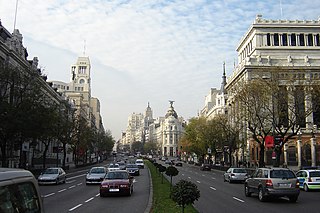
Calle de Alcalá is among the longest streets in Madrid. It starts at the Puerta del Sol and goes on for 11 km, to the northeastern outskirts of the city. Henry David Inglis described it in 1837 as "long, of superb width, and flanked by a splendid range of unequal buildings".

Vicálvaro is a district in the southeast of Madrid, Spain. It is named after the former municipality absorbed into the municipality of Madrid in 1951.
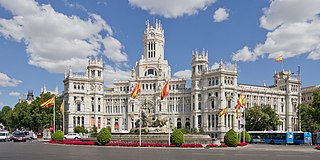
Cibeles Palace, formally known as Palacio de Comunicaciones and Palacio de Telecomunicaciones until 2011, is a complex composed of two buildings with white facades and is located in one of the historical centres of Madrid, Spain. Formerly the city's main post office and telegraph and telephone headquarters, it is now occupied by Madrid City Council, serving as the city hall, and the public cultural centre CentroCentro.

Acacias or Las Acacias is an administrative neighborhood (barrio) of Madrid belonging to the district of Arganzuela. It has an area of 1.074172 km2 (0.414740 sq mi). As of 1 February 2020, it has a population of 37,049.

The Walls of Seville are a series of defensive walls surrounding the Old Town of Seville. The city has been surrounded by walls since the Roman period, and they were maintained and modified throughout the subsequent Visigoth, Islamic and finally Castilian periods. The walls remained intact until the 19th century, when they were partially demolished after the revolution of 1868. Some parts of the walls still exist, especially around the Alcázar of Seville and some curtain walls in the barrio de la Macarena.
The Walls of Philip II were walls in the city of Madrid that Philip II, in 1566, constructed for fiscal and sanitary control. The walls covered an area of about 125 hectares.

Embajadores is an administrative neighborhood (barrio) of Madrid, belonging to the Centro District.
An Ayuntamiento is the public organisation charged with the task of administering and governing the municipalities of Spain not bound to the regime of concejo abierto.

Torcuato José Benjumeda y Laguada was a Spanish architect. A disciple of Torcuato Cayón, he was one of the most important Neoclassical architects in Andalusia, designing several of the most prominent buildings in Cádiz. These include the Royal Prison, the Church of St. Peter and St. Paul and the Ayuntamiento.

The Calle de la Montera is a pedestrian street in the centre of Madrid. Starting from the south, it links the Puerta del Sol and the so-called Red de San Luis. It presents a south-north positive slope.

The calle de Serrano, or simply Serrano, is a street in Madrid, Spain. It is noted as location for luxury flagship stores.
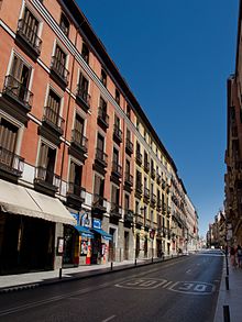
The Calle de Toledo is a historic street in central Madrid, Spain, running across the Centro and Arganzuela districts.

The Calle de San Bernardo is a street in central Madrid, Spain. Located in the Centro and Chamberí districts, it once was the former road in and out of the city from the North.

The Ronda de Atocha is an thoroughfare in Madrid, Spain. It is part of the rim of streets rounding up the city historical centre, following the layout of the Walls of Philip IV.