 | |||
| Type | street | ||
|---|---|---|---|
| Length | 1.3 km (0.8 mi) | ||
| Location | Madrid, Spain | ||
| Northwest end | Plaza de Santa Cruz | ||
| Southeast end | Plaza del Emperador Carlos V | ||
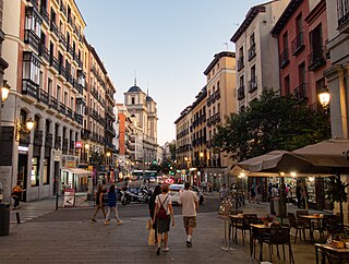
The Calle de Atocha is a street in Madrid, Spain. It constitutes a major axis within the Centro District.
| | |||
| Type | street | ||
|---|---|---|---|
| Length | 1.3 km (0.8 mi) | ||
| Location | Madrid, Spain | ||
| Northwest end | Plaza de Santa Cruz | ||
| Southeast end | Plaza del Emperador Carlos V | ||
The Calle de Atocha is a street in Madrid, Spain. It constitutes a major axis within the Centro District.
It roughly defines an axis cutting through the old city town from northwest to southeast, [1] straddling along the border between the current Embajadores and Cortes neighborhoods for part of its total 1.3 km long length. [2] It starts at the Plaza de Santa Cruz, ending at the Plaza del Emperador Carlos V. [3]
Along the initial stretch, closer to the royal palace, chiefly residential housing was erected, with some later conventual additions. [1] Meanwhile, the lower, southeasternmost end of the street was chiefly purposed for Hospital buildings already since the foundation of the Hospital of Antón Martín in the mid-16th century. [1] Linked since ancient times to the Spanish Crown, [4] it was the regular route of the traditional royal weekly ceremonies with the monarchs moving to the Sanctuary of Atocha. [5]


Paseo de Recoletos is a wide boulevard in central Madrid leading from Plaza de Cibeles to Plaza de Colón.

Plaza del Emperador Carlos V is a square in the city of Madrid. It is named after Charles V, Holy Roman Emperor, who also reigned in Spain as Charles I. However, it is referred to as Plaza de Atocha, because it is where Madrid Atocha railway station is located.
Miguel Rosich y Más was Mayor of Ponce, Puerto Rico, from 8 May 1889 until 31 March 1890, and again in 1897, starting on 1 April 1897.
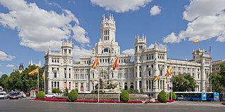
Cibeles Palace, formally known as Palacio de Comunicaciones and Palacio de Telecomunicaciones until 2011, is a complex composed of two buildings with white facades and is located in one of the historical centres of Madrid, Spain. Formerly the city's main post office and telegraph and telephone headquarters, it is now occupied by Madrid City Council, serving as the city hall, and the public cultural centre CentroCentro.

Atocha is a central ward (barrio) of Madrid belonging to the district of Arganzuela.

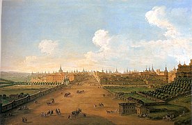
The Walls of Madrid are the five successive sets of walls that surrounded the city of Madrid from the Middle Ages until the end of the 19th century. Some of the walls had a defensive or military function, while others made it easy to tax goods entering the city. Towards the end of the 19th century the demographic explosion that came with the Industrial Revolution prompted urban expansion throughout Spain. Older walls were torn down to enable the expansion of the city under the grid plan of Carlos María de Castro.

Embajadores is an administrative neighborhood (barrio) of Madrid, belonging to the Centro District.

Cuatro Caminos is a neighborhood (barrio) of Madrid belonging to the district of Tetuán.
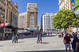
The Callao Square is located at the centre of the Spanish capital of Madrid.

The Calle Mayor is a centric street in Madrid, Spain. Located in the Centro District, the Calle Mayor starts in the Puerta del Sol and ends at the cuesta de la Vega.

The calle de Bravo Murillo is a major street in Madrid, Spain.
The calle de la Princesa is a street in Madrid, Spain.

The Avenida de Asturias is a street in northwest Madrid, located in the district of Tetuán. A relatively recent urban development, opened in 2000, it hosts a multitudinous Sunday flea market since 2005.
The Calle de Toledo is a historic street in central Madrid, Spain, running across the Centro and Arganzuela districts.

The Calle de San Bernardo is a street in central Madrid, Spain. Located in the Centro and Chamberí districts, it once was the former road in and out of the city from the North.

The Ronda de Atocha is an thoroughfare in Madrid, Spain. It is part of the rim of streets rounding up the city historical centre, following the layout of the Walls of Philip IV.

Plaza de la Reina is a central plaza in Valencia, Spain. It brings together, among others, Calle de la Paz, Calle del Mar, Calle del Cabilleros, Calle de los Bordadores, Calle de Santa Catalina, and Calle de Santo Vincente Mártir. The plaza includes the baroque door of the Irons, which gives access to the Valencia Cathedral. It is also noteworthy for views of two important bell towers of Valencia, the Santa Catalina and the Miguelete Tower.

The Calle de Génova is a street in Madrid, Spain. It is the dividing line between the neighbourhoods of Justicia and Almagro, in the respective districts of Centro and Chamberí. It runs from the Plaza de Alonso Martínez to the Plaza de Colón.

The Plaza de Galicia is a 20th century square located in the city centre of Pontevedra (Spain), on the edge of the Campolongo neighbourhood.

The history of the Puerta del Sol represents an essential part of the memory of the Villa de Madrid, not only because the Puerta del Sol is a point of frequent passage, but also because it constitutes the "center of gravity" of Madrid's urban planning. The square has been acquiring its character as a place of historical importance from its uncertain beginnings as a wide and impersonal street in the sixteenth century, to the descriptions of the first romantic travelers, the receptions of kings, popular rebellions, demonstrations, etc. It has been the scene of major events in the life of the city, from the struggle against the French invaders in 1808 to the proclamation of the Second Republic in 1931, and it has also retained its place as the protagonist of the custom of serving twelve grapes on New Year's Eve, to the sound of the chimes struck by the Correos clock. Today it is a communications hub, a meeting point, a place of appointments, a place for celebrations and the beginning of demonstrations in the Capital.