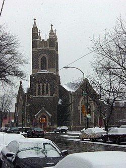
Calvary United Methodist Church (Philadelphia)

Last updated
The church undergoing renovation in 2005 Calvary UMC Phila west.jpg
The church undergoing renovation in 2005

Calvary United Methodist Church is located at 801 S. 48th Street, on the southeast corner of 48th Street & Baltimore Avenue, in Philadelphia, Pennsylvania. The church was founded in 1896 as Calvary Methodist Episcopal and the current structure was completed in 1906. [1] [2]

Contents

Calvary United Methodist Church rents space in its building to a number of churches and community groups. The church also is home to "Calvary Center for Culture and Community" (CCCC), an affiliated non-profit organization that raises funds for building restoration and facilitates use by community groups.

Calvary UMC is a member of the Reconciling Ministries Network, a movement within the United Methodist Church to formally and intentionally welcome LGBT persons to full inclusion in the life of the church. The congregation made this declaration in 1985, shortly after the network's formation.

Related Research Articles

<span class="mw-page-title-main">Community College of Philadelphia</span> Community college of Philadelphia

The Community College of Philadelphia (CCP) is a public community college with campuses throughout Philadelphia, Pennsylvania. The college was founded in 1965 and is accredited by the Middle States Commission on Higher Education. It offers over 100 associate degree and certificate programs through its four locations.

<span class="mw-page-title-main">Mother Bethel A.M.E. Church</span> Historic church in Pennsylvania, United States

The Mother Bethel African Methodist Episcopal Church is an historic church and congregation which is located at 419 South 6th Street in Center City Philadelphia, Pennsylvania, USA. The congregation, founded in 1794, is the oldest African Methodist Episcopal congregation in the nation.

<span class="mw-page-title-main">Cradle of Liberty Council</span> Boy Scouts of America council

The Cradle of Liberty Council (#525) is a Boy Scouts of America council created in 1996 with the merger of the former Philadelphia Council and the former Valley Forge Council.

<span class="mw-page-title-main">Charles Albert Tindley</span> American minister and composer (1851-1933)

Charles Albert Tindley was an American Methodist minister and gospel music composer. His composition "I'll Overcome Someday" is credited as the basis for the U.S. Civil Rights anthem "We Shall Overcome". Another of his hymns is "(Take Your Burden to the Lord and) Leave It There" (1916), as well as "What Are They Doing in Heaven?" (1901).

<span class="mw-page-title-main">WPEB</span> Radio station in Philadelphia

WPEB is a variety formatted broadcast radio station licensed to Philadelphia, Pennsylvania, United States.

<span class="mw-page-title-main">Walnut Street (Philadelphia)</span>

Walnut Street is located in Center City Philadelphia and extends to the Delaware River waterfront and West Philadelphia. Walnut Street has been characterized as "the city's premier shopping district" by The Philadelphia Inquirer. A portion of the street commonly called Rittenhouse Row was ranked 12th in 2005 by Women's Wear Daily among its list of the most expensive retail streets in North America, with rents of $90 per square foot, and is home to several "upscale dining, retail and cultural" establishments. In 2013, rents rose to an average of $107 a foot, a growth of 34% over 2012 and the largest percentage growth of any retail corridor in the country.

<span class="mw-page-title-main">City of Conquerors Church, Philadelphia</span> Church in Philadelphia, PA

City of Conquerors is a church started by We Are More Than Conquerors Deliverance Ministries. The current building was formerly the West Philadelphia Jewish Community Center, as evidenced by the Jewish symbols on the exterior of the building at 11 South 63rd Street, Philadelphia, Pennsylvania.

St. Paul United Methodist Church is located in the historic Grant Park neighborhood of Atlanta, Georgia. For a time in the early 1900s, St. Paul had the largest Methodist congregation in the Southeastern United States. The church organ was acquired at the Cotton States Exhibition in 1887. St. Paul's stained glass windows, which date back to 1907, are being refurbished. St. Paul is a main stop on tours of the Grant Park neighborhood given by the Atlanta Preservation Center. St. Paul is also home to the Grant Park Cooperative Preschool. St. Paul, the Grant Park Cooperative Preschool and the Grant Park Parent Network host the annual Grant Park Candlelight Tour of Homes, which also includes an artist marketplace and a Winter Wonderland for children. The Candlelight Tour of Homes begins at St. Paul.

Chestnut Street is a major historic street in Philadelphia, Pennsylvania. It was originally named Wynne Street because Thomas Wynne's home was there. William Penn renamed it Chestnut Street in 1684. It runs east–west from the Delaware River waterfront in downtown Philadelphia through Center City and West Philadelphia. The road crosses the Schuylkill River on the Chestnut Street Bridge. It serves as eastbound Pennsylvania Route 3 between 63rd and 33rd Streets.

<span class="mw-page-title-main">Johnsville, Maryland</span>

Johnsville is an unincorporated community in Frederick County, Maryland, United States. It is located approximately halfway between Libertytown and Union Bridge along Maryland Route 75. The Kitterman-Buckey Farm was listed on the National Register of Historic Places in 2005.

<span class="mw-page-title-main">Pennsylvania School for the Deaf</span> United States historic place

The Pennsylvania School for the Deaf is the third-oldest school of its kind in the United States. Its founder, David G. Seixas (1788–1864), was a Philadelphia crockery maker-dealer who became concerned with the plight of impoverished deaf children who he observed on the city's streets. The current school building is listed by the National Register of Historic Places, and two former campuses are similarly recognized.

<span class="mw-page-title-main">University City Science Center</span>

The University City Science Center (UCSC) was established as the first and largest urban research park in the United States. It was established in 1963, within the demolished Black Bottom neighborhood of Philadelphia, now known as University City. Today it offers startup support services, allocates capital, gathers the innovation community, and builds inclusive STEM pathways for Philadelphia youth and adults.

<span class="mw-page-title-main">Moscow United Methodist Church</span>

Moscow United Methodist Church is located in Moscow, Pennsylvania, on Church Street near Main Street. It is a church of the United Methodist Church that operates in the Susquehanna Conference.

<span class="mw-page-title-main">Occupy Philadelphia</span>

Occupy Philadelphia was a collaboration that included nonviolent protests and demonstrations with an aim to overcome economic inequality, corporate greed and the influence of corporations and lobbyists on government. The protest took place at Thomas Paine Plaza, which is adjacent to Philadelphia's City Hall.

<span class="mw-page-title-main">Briggsdale (Columbus, Ohio)</span>

Briggsdale is a neighborhood of Franklin County in the city of Columbus, Ohio. The neighborhood is on the west/southwest side of the city within the Hilltop area. The area was first settled and founded by the family of Joseph M. Briggs, after whom the neighborhood was named. Joseph Briggs was an active figure in the early years of the township and county operations. The Briggsdale Methodist church was founded with his help, and it now exists as the New Horizons Methodist Church. The present day Briggsdale neighborhood is located near the historical Green Lawn Cemetery to the north as well as Briggs High School to the west.

<span class="mw-page-title-main">Congregation Kesher Israel (Philadelphia)</span>

Congregation Kesher Israel is a synagogue located in the Society Hill section of Center City Philadelphia. The synagogue is home to an active congregation with Shabbat and holy day services, a Hebrew school, adult education, and community programming. It is affiliated with the conservative movement.

<span class="mw-page-title-main">Third Presbyterian Church (Chester, Pennsylvania)</span> United States historic place

The Third Presbyterian Church was a historic Presbyterian Church founded in 1872 in Chester, Pennsylvania. It was located at 9th and Potter Streets. The church was the location of the first summer bible school in 1912. The congregation closed in 1986 and was thereafter owned by the Chester Historical Preservation Committee. It was a stone Gothic Revival building designed by the noted Philadelphia architect Isaac Pursell. The church was listed on the National Register of Historic Places in November 2019 but severely damaged by a five-alarm fire on May 28, 2020.

<span class="mw-page-title-main">Asbury AME Church</span> African Methodist Episcopal Church in Chester, Pennsylvania

Asbury AME Church is an African Methodist Episcopal Church founded in 1845 in Chester, Delaware County, Pennsylvania, United States. It is the second African Methodist Episcopal church founded in Chester behind the Union African Methodist Church in 1832. Asbury AME Church is located at 1712 Providence Avenue and is an active worship center.

<span class="mw-page-title-main">Madison Street Methodist Episcopal Church</span>

Madison Street Methodist Episcopal Church is a Methodist Episcopal Church built in 1874 in Chester, Delaware County, Pennsylvania, United States. It is located at 701 Madison Street. The building is currently being used by the Wesley House Community Corporation as a homeless shelter.

North Philadelphia/East is a neighborhood in the eastern central part of North Philadelphia section of Philadelphia, Pennsylvania, United States.

References

  1. "About." Philadelphia, Pennsylvania: Calvary United Methodist Church, retrieved online February 23, 2019.
  2. van Wagtendonk, Anya. "To save the world, first they must save a building in West Philly." Philadelphia, Pennsylvania: The Inquirer, July 12, 2018.

Map

Coordinates: 39°56′54″N75°13′08″W / 39.948303°N 75.218852°W / 39.948303; -75.218852