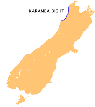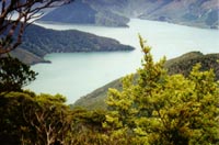
The Karamea Bight is the name given to a large bay in the Tasman Sea formed by a curved stretch of the West Coast of New Zealand's South Island. It stretches for 100 kilometres north from Cape Foulwind to just north of the mouth of the Heaphy River.

The Nimrod Glacier is a major glacier about 85 nautical miles long, flowing from the polar plateau in a northerly direction through the Transantarctic Mountains into the Ross Ice Shelf, Antarctica.

The Kaikōura Ranges are two parallel ranges of mountains located in the northeast of the South Island of New Zealand. The two ranges are visible from a great distance, including from the southern coast of the North Island.
The Commonwealth Range is a north-south trending range of rugged mountains, 60 nautical miles long, located within the Queen Maud Mountains on the Dufek Coast of the continent of Antarctica. The range borders the eastern side of Beardmore Glacier from Keltie Glacier to the Ross Ice Shelf. The range is southeast of the Queen Alexandra Range, which is to the west of the Beardmore Glacier. It is west of the Hughes Range and north of the Supporters Range and the Barton Mountains.

Fairy Bay is east of Mount Stanley, elevation 971 metres (3,186 ft), in Pelorus Sound / Te Hoiere, part of the Marlborough Sounds Maritime Park, at the top of the South Island, New Zealand. The origin of the name is thought to have been the fairy penguin. It has previously been known as Falls River Bay and Sandfly Bay. A neighbouring bay immediately to the south is called Penguin Bay.
Medbury is a rural locality in the Canterbury region of New Zealand's South Island, situated near the Hurunui River and State Highway 7. There is no longer a significant population base forming a township, just rural properties.

The Saint Arnaud Range is a mountain range in the central north of New Zealand's South Island. It lies between Lake Rotoiti and the upper reaches of the Wairau River, and marks the eastern boundary of Nelson Lakes National Park.

The Kaihu River is a river of the far north of New Zealand's North Island. It originates in native forest near Trounson Kauri Park flows southeast from just south of Waipoua Forest, reaching the Wairoa River at the town of Dargaville.
The Marchburn River is a river of Marlborough Region, New Zealand.

The Medway River of the Marlborough Region of New Zealand's South Island originates in Inland Kaikoura Range. It flows northwest then north from its sources, to meet the Awatere River 20 kilometres (12 mi) southwest of Seddon.
The Otaua River is a river of the Northland Region of New Zealand's North Island. It is a tributary of the Punakitere River, which it reaches 5 kilometres (3 mi) south of the latter's outflow into the Waima River
The Shin River is a river in New Zealand's Marlborough Region. The 10-km long Shin rises from its sources in the Inland Kaikoura Range and flows north to reach the Hodder River, which is part of the Awatere River system, located 40 kilometres (25 mi) southwest of Seddon.
The Stanton River is a river of the Canterbury region of New Zealand's South Island. IUt flows southeast through the Hundalee Hills, turning southwest to reach the Waiau Uwha River 7 kilometres (4 mi) east of Waiau.
The Tummil River is a river of the Marlborough Region of New Zealand's South Island. It flows northwest from rough hill country north of Mount Horrible to reach the Avon River southwest of Blenheim.
The Waikākaho River is a river of the Marlborough Region of New Zealand's South Island. It flows south from its sources southeast of Havelock to reach the Wairau River 5 kilometres (3 mi) west of Tuamarina.
The Waimangarara River is a river of the Marlborough Region of New Zealand's South Island. It flows generally south from its origins in the Seaward Kaikōura Range to reach the Pacific Ocean 5 kilometres (3 mi) north of Kaikōura.

The Wakamarina River is a river of the Marlborough Region of New Zealand's South Island. It flows generally northeast from its origins in the Richmond Range to reach the Pelorus River at the settlement of Canvastown, 10 kilometres (6 mi) west of Havelock. In 1864, gold was found in the river near Havelock, and soon 6,000 men were working in the area. The gold rush did not last long and most miners moved on to the West Coast gold rush.
The Land Glacier is a broad, heavily crevassed glacier, about 35 nautical miles long, descending into Land Bay in Marie Byrd Land, Antarctica. It was discovered by the United States Antarctic Service (1939–41) and named for Rear Admiral Emory S. Land, Chairman of the United States Maritime Commission.
The Grosvenor Mountains are a group of widely scattered mountains and nunataks rising above the Antarctic polar plateau east of the head of Mill Glacier, extending from Mount Pratt in the north to the Mount Raymond area in the south, and from Otway Massif in the northwest to Larkman Nunatak in the southeast.
Molar Massif is a large mountain massif immediately east of the Lanterman Range in the Bowers Mountains of Antarctica. It was mapped by the United States Geological Survey (USGS) from ground surveys and United States Navy air photos, 1960–1964. The descriptive name was applied by the United States Advisory Committee on Antarctic Names (US-ACAN) because, when viewed in plan, the outline of the massif resembles a molar tooth.


