Camarinal Sill

Last updated
The Strait of Gibraltar as seen from space. STS059-238-074 Strait of Gibraltar.jpg
The Strait of Gibraltar as seen from space.
Natural Flow over the Camarinal Sill Camarinal Still Water Mixing (Simplified).jpg
Natural Flow over the Camarinal Sill

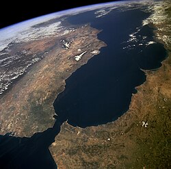
The Camarinal Sill is the sill separating the Mediterranean Sea and the Atlantic Ocean. This threshold is the shallowest seafloor pass between the Iberian Peninsula and Africa. It is located approximately 25 km west of the narrowest section of the Strait of Gibraltar and 20 km east of the Espartel Sill, at 35°56′N5°45′W / 35.933°N 5.750°W / 35.933; -5.750 (Camarinal Sill) , at a depth of 280 m. [1] [2]

Its formation is linked to the Zanclean flood and the termination of the Messinian salinity crisis, when the Mediterranean was abruptly refilled through the Strait of Gibraltar, excavating the 900-metre-deep gorge that lies underneath the water. [1] [2] A competing hypothesis suggests that both the gorge and the Camarinal Sill are the result of fluvial erosion during the desiccation of the Mediterranean (Messinian salinity crisis).[ citation needed ]

Marine waters must climb to that depth when flowing between both ocean domains. [1] [2] During World War II, submarines used the upper inflow current and the lower outflow current to go in and out of the Mediterranean Sea without using their engines, to avoid being noticed from the surface. [3]

Related Research Articles

<span class="mw-page-title-main">Mediterranean Sea</span> Sea between Africa, Asia, and Europe

The Mediterranean Sea is a sea connected to the Atlantic Ocean, surrounded by the Mediterranean Basin and almost completely enclosed by land: on the east by the Levant in West Asia, on the north by Anatolia in West Asia and Southern Europe, on the south by North Africa, and on the west almost by the Morocco–Spain border. The Mediterranean Sea covers an area of about 2,500,000 km2 (970,000 sq mi), representing 0.7% of the global ocean surface, but its connection to the Atlantic via the Strait of Gibraltar—the narrow strait that connects the Atlantic Ocean to the Mediterranean Sea and separates the Iberian Peninsula in Europe from Morocco in Africa—is only 14 km (9 mi) wide.

<span class="mw-page-title-main">Strait of Gibraltar</span> Strait connecting the Atlantic to the Mediterranean

The Strait of Gibraltar is a narrow strait that connects the Atlantic Ocean to the Mediterranean Sea and separates Europe from Africa. The two continents are separated by 7.7 nautical miles at its narrowest point. Ferries cross between the two continents every day in as little as 35 minutes. The Strait's depth ranges between 300 and 900 metres.

<span class="mw-page-title-main">Sea of Azov</span> Sea on the south of Eastern Europe linked to the Black Sea

The Sea of Azov is an inland shelf sea in Eastern Europe connected to the Black Sea by the narrow Strait of Kerch, and sometimes regarded as a northern extension of the Black Sea. The sea is bounded by Russia on the east, and by Ukraine on the northwest and southwest. It is an important access route for Central Asia, from the Caspian Sea via the Volga–Don Canal.

<span class="mw-page-title-main">Labrador Sea</span> Arm of the North Atlantic Ocean

The Labrador Sea is an arm of the North Atlantic Ocean between the Labrador Peninsula and Greenland. The sea is flanked by continental shelves to the southwest, northwest, and northeast. It connects to the north with Baffin Bay through the Davis Strait. It is a marginal sea of the Atlantic.

In geomorphology, an outburst flood—a type of megaflood—is a high-magnitude, low-frequency catastrophic flood involving the sudden release of a large quantity of water. During the last deglaciation, numerous glacial lake outburst floods were caused by the collapse of either ice sheets or glaciers that formed the dams of proglacial lakes. Examples of older outburst floods are known from the geological past of the Earth and inferred from geomorphological evidence on Mars. Landslides, lahars, and volcanic dams can also block rivers and create lakes, which trigger such floods when the rock or earthen barrier collapses or is eroded. Lakes also form behind glacial moraines or ice dams, which can collapse and create outburst floods.

<span class="mw-page-title-main">Strait of Sicily</span> The strait between Sicily and Tunisia

The Strait of Sicily is the strait between Sicily and Tunisia. The strait is about 145 kilometres (90 mi) wide and divides the Tyrrhenian Sea and the western Mediterranean Sea, from the eastern Mediterranean Sea. The maximum depth is 316 meters (1,037 ft). The island of Pantelleria lies in the middle of the strait.

<span class="mw-page-title-main">Alboran Sea</span> Westernmost portion of the Mediterranean Sea

The Alboran Sea is the westernmost portion of the Mediterranean Sea, lying between the Iberian Peninsula and the north of Africa. The Strait of Gibraltar, which lies at the west end of the Alboran Sea, connects the Mediterranean with the Atlantic Ocean.

<span class="mw-page-title-main">Messinian salinity crisis</span> Drying-up of the Mediterranean Sea from 5.96 to 5.33 million years ago

In the Messinian salinity crisis the Mediterranean Sea went into a cycle of partial or nearly complete desiccation (drying-up) throughout the latter part of the Messinian age of the Miocene epoch, from 5.96 to 5.33 Ma. It ended with the Zanclean flood, when the Atlantic reclaimed the basin.

<span class="mw-page-title-main">Zanclean</span> Earliest age on the geologic time scale of the Pliocene era

The Zanclean is the lowest stage or earliest age on the geologic time scale of the Pliocene. It spans the time between 5.332 ± 0.005 Ma and 3.6 ± 0.005 Ma. It is preceded by the Messinian Age of the Miocene Epoch, and followed by the Piacenzian Age.

Spartel Bank or Majuán Bank is a submerged former island located in the Strait of Gibraltar near Cape Spartel and the Spartel Sill. Its highest point is currently 56 metres (184 ft) below the surface. Spartel Bank is one of several seamounts in the bed of Gibraltar Strait; similar but deeper seamounts are found at Camarinal Sill and further east. These represent landslide blocks which slid south from the north bank of the Strait of Gibraltar when the strait was formed, possibly through erosion by inflowing waters of the Zanclean flood.

<span class="mw-page-title-main">Calanque</span> Narrow inlet on the Mediterranean coast

A calanque is a narrow, steep-walled inlet that is developed in limestone, dolomite, or other carbonate strata and found along the Mediterranean coast. A calanque is a steep-sided valley formed within karstic regions either by fluvial erosion or the collapse of the roof of a cave that has been subsequently partially submerged by a rise in sea level.

<span class="mw-page-title-main">Fram Strait</span> Passage between Greenland and Svalbard

The Fram Strait is the passage between Greenland and Svalbard, located roughly between 77°N and 81°N latitudes and centered on the prime meridian. The Greenland and Norwegian Seas lie south of Fram Strait, while the Nansen Basin of the Arctic Ocean lies to the north. Fram Strait is noted for being the only deep connection between the Arctic Ocean and the World Oceans. The dominant oceanographic features of the region are the West Spitsbergen Current on the east side of the strait and the East Greenland Current on the west.

<span class="mw-page-title-main">Betic corridor</span> Strait of water

The Betic Corridor, or North-Betic Strait, was a strait of water connecting the Mediterranean Sea with the Atlantic Ocean that once separated the Iberian plate from the Eurasian Plate through the Betic Cordillera. Its closure approximately 5.96 million years ago during the Messinian period of the Miocene epoch, precipitated the Messinian Salinity Crisis, a period when the Mediterranean Sea evaporated partly or completely.

The Spartel or Espartel Sill is one of the sills separating the Mediterranean Sea and the Atlantic Ocean. This threshold is the second shallowest seafloor pass between the Iberian Peninsula and Africa. It is located near the Strait of Gibraltar and the Camarinal Sill, at 35°55′N5°47′W, at a depth of −300 m. The deep, salty and dense waters of the Mediterranean must climb to that depth when flowing towards the Atlantic.

<span class="mw-page-title-main">Aquatic sill</span> Seafloor barrier restricting water movement between basins

An aquatic sill is a sea floor barrier of relatively shallow depth that restricts water movement between benthic zones of an oceanic basin or lake bottom. There are roughly 400 sills in the Earth's oceans, covering 0.01% of the seafloor. A classic example is the Strait of Gibraltar Gateway between the Mediterranean Sea and the Atlantic Ocean.

<span class="mw-page-title-main">Zanclean flood</span> Theoretical refilling of the Mediterranean Sea between the Miocene and Pliocene Epochs

The Zanclean flood or Zanclean deluge is theorized to have refilled the Mediterranean Sea 5.33 million years ago. This flooding ended the Messinian salinity crisis and reconnected the Mediterranean Sea to the Atlantic Ocean, although it is possible that even before the flood there were partial connections to the Atlantic Ocean. The re-connection marks the beginning of the Zanclean age which is the name given to the earliest age on the geologic time scale of the Pliocene.

Daniel Garcia-Castellanos is a Spanish scientist at the Spanish National Research Council (CSIC) who investigates in the field of geophysics and is known for his theory about the catastrophic flooding of the Mediterranean Sea in the recent geological past, an event known as the Zanclean flood. Other scientific contributions deal with the evolution of the Earth's relief as a result of the deep geodynamic phenomena of the Earth’s interior interacting with the erosion and climate at the surface.

<span class="mw-page-title-main">Mediterranean outflow</span>

The Mediterranean Outflow is a current flowing from the Mediterranean Sea towards the Atlantic Ocean through the Strait of Gibraltar. Once it has reached the western side of the Strait of Gibraltar, it divides into two branches, one flowing westward following the Iberian continental slope, and another returning to the Strait of Gibraltar circulating cyclonically. In the Strait of Gibraltar and in the Gulf of Cádiz, the Mediterranean Outflow core has a width of a few tens of km. Through its nonlinear interactions with tides and topography, as it flows out of the Mediterranean basin it undergoes such strong mixing that the water masses composing this current become indistinguishable upon reaching the western side of the strait.

Incised valleys are mountain-valley-like features that commonly result from river down cutting into coastal plains and continental shelves in response to marine regression. They are the key evidence to identify sequence boundary on seismic profiles and outcrops. The magnitudes of their down cutting have been used to estimate the global sea-level variations.

<span class="mw-page-title-main">Malta Escarpment</span> Mediterranean undersea geological feature

The Malta Escarpment is a prominent undersea geological feature of the Mediterranean Sea that runs southwards from the eastern coasts from Sicily and the Malta towards the Medina Seamounts near the African coast and divides the Mediterranean Sea naturally into western and eastern regions. It is also known as the Sicily-Malta Escarpment.

References

  1. 1 2 3 "The boiling-water phenomena at Camarinal Sill, the strait of Gibraltar. Bruno, Juan-Alonso, Cózarb, et al". Science Direct.
  2. 1 2 3 "Morphology and structure of the Camarinal Sill from high-resolution bathymetry: Evidence of fault zones in the Gibraltar Strait" via www.researchgate.net.
  3. Paterson, Lawrence (2007). U-boats in the Mediterranean, 1941 - 1944 (1. publ ed.). London: Chatham. pp. 19, 182. ISBN   9781861762900.