Camp Ashby

Last updated

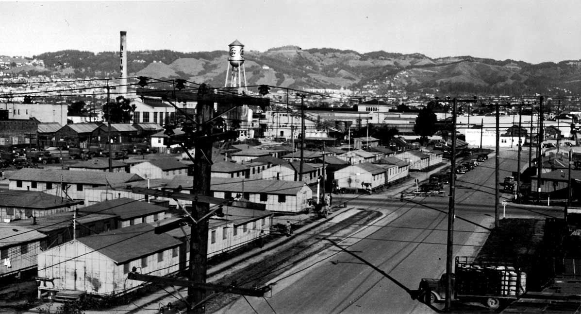
Camp Ashby was a temporary U.S. Army installation sited in Berkeley, California during World War II. It was activated on July 1, 1942. The site contained housing for 30 officers and 612 enlisted and non-commissioned officers. It was located near Ashby and Seventh street. The base was named for Ashby Avenue, a nearby thoroughfare (at the time, part of State Highway 24, now 13), which in turn was named for one of Berkeley's earliest settlers, William Ashby (Aug.1, 1819-July 12, 1896).

Camp Ashby was used to quarter and train the 779th Military Police Battalion, an African American unit led by white officers. [1]

Related Research Articles

<span class="mw-page-title-main">Berkeley, California</span> City in California, United States

Berkeley is a city on the eastern shore of San Francisco Bay in northern Alameda County, California, United States. It is named after the 18th-century Irish bishop and philosopher George Berkeley. It borders the cities of Oakland and Emeryville to the south and the city of Albany and the unincorporated community of Kensington to the north. Its eastern border with Contra Costa County generally follows the ridge of the Berkeley Hills. The 2020 census recorded a population of 124,321.

<span class="mw-page-title-main">Marine Corps Base Camp Pendleton</span> US Marine Corps base in California

Marine Corps Base Camp Pendleton is the major West Coast base of the United States Marine Corps and is one of the largest Marine Corps bases in the US. It is on the Southern California coast in San Diego County and is bordered by Oceanside to the south, San Clemente and Orange County to the north, Riverside County to the northeast, and Fallbrook to the east.

<span class="mw-page-title-main">Turner Ashby</span> Confederate cavalry officer during the American Civil War

Turner Ashby Jr. was an American officer. He was a Confederate cavalry commander in the American Civil War.

<span class="mw-page-title-main">1998 Cavalese cable car crash</span> 1998 disaster in which a U.S. Navy aircraft flew into ski lift cables in Cavalese, Italy

The Cavalese cable car crash, also known as the Cermis massacre, occurred on February 3, 1998, near the Italian town of Cavalese, a ski resort in the Dolomites some 40 kilometres (25 mi) northeast of Trento. Twenty people were killed when a United States Marine Corps EA-6B Prowler aircraft, flying too low and against regulations, in order for the pilots to "have fun" and "take videos of the scenery", cut a cable supporting a cable car of an aerial lift.

<span class="mw-page-title-main">Chalmers Johnson</span>

Chalmers Ashby Johnson was an American political scientist specializing in comparative politics, and professor emeritus of the University of California, San Diego. He served in the Korean War, was a consultant for the CIA from 1967 to 1973 and chaired the Center for Chinese Studies at the University of California, Berkeley from 1967 to 1972. He was also president and co-founder with Steven Clemons of the Japan Policy Research Institute, an organization that promotes public education about Japan and Asia.

<span class="mw-page-title-main">California State Route 13</span> State highway in Alameda County, California, United States

State Route 13 is a state highway in the U.S. state of California. It runs entirely in Alameda County, connecting Interstate 580 in Oakland to Interstate 80/Interstate 580 in Berkeley.

<span class="mw-page-title-main">California State Route 24</span> Highway in California

State Route 24 is a heavily traveled east–west state highway in the U.S. state of California that serves the eastern side of the San Francisco Bay Area. A freeway throughout its entire length, it runs from the Interstate 580/Interstate 980 interchange in Oakland, and through the Caldecott Tunnel under the Berkeley Hills, to the Interstate 680 junction in Walnut Creek. It lies in Alameda County, where it is highly urban, and Contra Costa County, where it passes through wooded hillsides and suburbs. SR 24 is a major connection between the San Francisco–Oakland Bay Bridge/MacArthur Maze complex and the inland cities of the East Bay.

<span class="mw-page-title-main">Caldecott Tunnel</span> Four-bore passage for CA SR 24 under the Berkeley Hills

The Caldecott Tunnel is an east–west highway tunnel through the Berkeley Hills between Oakland and Orinda, California. Its four bores carry California State Route 24. Named after Thomas E. Caldecott, former mayor of Berkeley, it opened in 1937 as a two-bore tunnel. The third bore opened in 1964 and the fourth bore in 2013. Currently, the two oldest bores carry eastbound traffic and the two newest bores carry westbound traffic.

<span class="mw-page-title-main">Battle of San Pasqual</span> Mexican-American War battle

The Battle of San Pasqual, also spelled San Pascual, was a military encounter that occurred during the Mexican–American War in what is now the San Pasqual Valley community of the city of San Diego, California. The series of military skirmishes ended with both sides claiming victory, and the victor of the battle is still debated. On December 6 and December 7, 1846, General Stephen W. Kearny's US Army of the West, along with a small detachment of the California Battalion led by a Marine Lieutenant, engaged a small contingent of Californios and their Presidial Lancers Los Galgos, led by Major Andrés Pico. After U.S. reinforcements arrived, Kearny's troops were able to reach San Diego.

Point Lobos Ranch is an 1,315 acres (532 ha) parcel of land owned by the state of California in the northern region of Big Sur, California, United States. San Jose Creek on the ranch was the site of an Ohlone village for thousands of years. Europeans first visited the site when the Portola Expedition camped on the site for 10 days in the winter of 1769.

<span class="mw-page-title-main">Ashby station (BART)</span> Rapid transit station in San Francisco Bay Area

Ashby is a Bay Area Rapid Transit (BART) station located beneath Adeline Street to the south of its intersection with Ashby Avenue in South Berkeley of Berkeley, California. The station includes park-and-ride facilities with 715 automobile parking spaces in two separate parking lots.

KVTO is a radio station broadcasting a Chinese format. Licensed to Berkeley, California, United States, the station serves the San Francisco Bay Area. The station is currently owned by Phuong Pham, through licensee Pham Radio Communication LLC. Its tower is located in Berkeley, California, and is shared with KEAR.

Thomas Edwin Caldecott was a pharmacist and politician. From 1923, Caldecott served in politics in Alameda County, California in the San Francisco Bay Area until 1951. The Caldecott Tunnel which is a key highway link through the Berkeley Hills is named after him.

<span class="mw-page-title-main">Camp San Luis Obispo</span> California Army National Guard base

Camp San Luis Obispo is the original home of the California Army National Guard. It served as an Infantry Division Camp and Cantonment Area for the United States Army during World War II.

<span class="mw-page-title-main">Fort Yuma</span> US Army fort (1851–1853) in California near Yuma, Arizona

Fort Yuma was a fort in California located in Imperial County, across the Colorado River from Yuma, Arizona. It was on the Butterfield Overland Mail route from 1858 until 1861 and was abandoned May 16, 1883, and transferred to the Department of the Interior. The Fort Yuma Indian School and the Saint Thomas Yuma Indian Mission now occupy the site. It is one of the "associated sites" listed as Yuma Crossing and Associated Sites on the National Register of Historic Places in the Yuma Crossing National Heritage Area. In addition, it is registered as California Historical Landmark #806.

South Berkeley is a neighborhood in the city of Berkeley, California. It extends roughly from Dwight Way to the city’s border with Oakland, between Telegraph Avenue in the east and either Sacramento Street or San Pablo Avenue in the west. It lies at an elevation of 102 feet.

The history of the University of California, Berkeley begins on October 13, 1849, with the adoption of the Constitution of California, which provided for the creation of a public university. On Charter Day, March 23, 1868, the signing of the Organic Act established the University of California, with the new institution inheriting the land and facilities of the private College of California and the federal funding eligibility of a public agricultural, mining, and mechanical arts college.

Camp Fremont was a World War I-era military base located near Palo Alto, California. Construction started in July, 1917 and the post closed in September, 1919. The post was named for John C. Frémont, a US Army officer and government official who was prominent in California during the 1850s.

<span class="mw-page-title-main">Shattuck Avenue</span>

Shattuck Avenue is a major city street running north–south through Berkeley, California, and Oakland, California. At its southern end, the street branches from Telegraph Avenue in Oakland's Temescal district, then ends at Indian Rock Park in the Berkeley Hills to the north. Shattuck Avenue is the main street of Berkeley, forming the spine of that city's downtown, and the site of the Gourmet Ghetto in North Berkeley. The street was named for Francis Kittredge Shattuck, an early landowner and booster who later served as Mayor of Oakland. Shattuck was largely responsible for the original construction of the road as well as for a railroad built along its route.

<span class="mw-page-title-main">Henry Marshall Ashby</span>

Henry Marshall Ashby was a Confederate States Army colonel during the American Civil War. Although he commanded a brigade from June 1864 and a division at the Battle of Bentonville and through the surrender of the Confederate force under the command of General Joseph E. Johnston, he was never appointed a brigadier general by Confederate President Jefferson Davis or confirmed as a general officer by the Confederate Senate.

References

  1. "Camp Ashby, Berkeley" (PDF). Berkeley Historical Society Newsletter. Retrieved 13 July 2019.